Category:1840s maps of New Hampshire
Jump to navigation
Jump to search
States of the United States: Alabama · Alaska · Arkansas · California · Connecticut · Delaware · Florida · Georgia · Hawaii · Idaho · Illinois · Indiana · Iowa · Kentucky · Louisiana · Maine · Maryland · Massachusetts · Michigan · Minnesota · Mississippi · Missouri · Montana · Nebraska · New Hampshire · New Jersey · New Mexico · New York · North Dakota · Ohio · Oklahoma · Oregon · Pennsylvania · Rhode Island · South Carolina · South Dakota · Tennessee · Texas · Utah · Vermont · Virginia · Washington · Wisconsin · Wyoming – Washington, D.C.
Puerto Rico
Puerto Rico
Media in category "1840s maps of New Hampshire"
The following 10 files are in this category, out of 10 total.
-
-
 Map of the Boston, Concord and Montreal Railroad from Concord to Haverhill, N.H. LOC gm70005004.tif 11,087 × 7,853; 249.1 MB
-

-

-
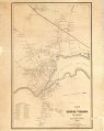
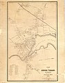 Plan of Exeter village, New Hampshire LOC 2008624187.jpg 6,653 × 8,377; 5.55 MB
-
 Plan of Exeter village, New Hampshire LOC 2008624187.tif 6,653 × 8,377; 159.45 MB
-

-

-
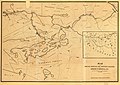
 Map of old Dunstable 1846.png 809 × 651; 273 KB
-
 Vermont and New Hampshire. NYPL1401776.tiff 4,848 × 5,475; 75.96 MB


