Category:Georgia State Route 15
Jump to navigation
Jump to search
 | number: | (fifteen) |
|---|---|---|
| State highways in Georgia (U.S. state): | 1 · 2 · 3 · 4 · 5 · 6 · 7 · 8 · 9 · 10 · 11 · 12 · 13 · 14 · 15 · 16 · 17 · 18 · 19 · 20 · 21 · 22 · 23 · 24 · 25 · 26 · 27 · 28 · 29 · 30 · 31 · 32 · 33 · 34 · 35 |
English: State Route 15 (SR 15) is a north–south route that transects the U.S. state of Georgia, east of its centerline. Its northern end is at the border of North Carolina, just north of Dilliard; its southern end is at the Florida border, just south of Folkston, where the actual highway continues southwards as Florida SR 15. SR 15 northbound merges into U.S. Route 441 (US 441) in Watkinsville. Then, the two highways run concurrently from there to the border with North Carolina.
State highway in eastern Georgia  | |||||
| Upload media | |||||
| Instance of | |||||
|---|---|---|---|---|---|
| Location | Georgia | ||||
| Transport network | |||||
| Owned by | |||||
| Maintained by | |||||
| Inception |
| ||||
| Length |
| ||||
| |||||
Subcategories
This category has the following 3 subcategories, out of 3 total.
G
Media in category "Georgia State Route 15"
The following 62 files are in this category, out of 62 total.
-
 Georgia 15 Alternate.svg 600 × 600; 5 KB
-
 Georgia 15 Connector.svg 600 × 600; 8 KB
-
 Georgia 15 Loop.svg 600 × 600; 9 KB
-
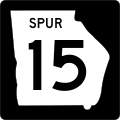 Georgia 15 Spur.svg 600 × 600; 11 KB
-
 3 US Routes; 4 GA State Routes, Folkston, GA.jpg 3,648 × 2,736; 2.07 MB
-
 Appling County, Big Satilla Creek bridge, GA15 121NB.jpg 5,184 × 3,456; 7.07 MB
-
 Blackshear 2 geodetic marker.jpg 5,184 × 3,456; 12.12 MB
-
 Blackshear Lodge No. 270.jpg 5,184 × 3,456; 7.37 MB
-
 Blackshear Post Office.jpg 5,184 × 3,456; 7.44 MB
-
 Burger King, Blackshear.JPG 4,320 × 3,240; 4.39 MB
-
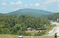
 Clayton viewed from Black Rock Mountain State Park August 2017.jpg 5,184 × 3,456; 7.71 MB
-
 First Baptist Church, Blackshear.jpg 5,184 × 3,456; 5.99 MB
-
 Folkston Seven-Way (31869167703).jpg 2,400 × 1,600; 2.94 MB
-
 Former Blackshear Bank.jpg 5,184 × 3,456; 7.13 MB
-
 GA 121 and 23 joins US 1-23-301 with GA 4 and 15.jpg 3,648 × 2,736; 2.06 MB
-
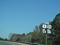
 GA121s-GA15nsSigns (32755617162).jpg 2,400 × 1,600; 1.72 MB
-
 GAMap-doton-Blackshear.PNG 258 × 300; 19 KB
-
 Georgia 15.svg 600 × 600; 4 KB
-
 Georgia state route 15 map.png 2,465 × 1,749; 1.01 MB
-
 Gibson McDonald Furniture Store.jpg 5,184 × 3,456; 6.66 MB
-
 Glassy Mountain, Georgia May 2017.jpg 2,394 × 1,542; 1.55 MB
-
 I-85 North GA - Exit 149 - US441 GA15 (41495518735).jpg 2,400 × 1,600; 1.47 MB
-
 Joseph Simmons Alexander, Sr. Memorial Bridge.jpg 5,184 × 3,456; 7.67 MB
-
 McDonald's Shell Gas Station, Blackshear.JPG 4,320 × 3,240; 4.48 MB
-
 McDonald's, Blackshear.JPG 4,320 × 3,240; 4.48 MB
-
 Michael's Deli, Blackshear.JPG 4,320 × 3,240; 4.44 MB
-
 NB US 1-23-301 (GA); 3-Distance Sign.jpg 3,648 × 2,736; 2.04 MB
-
 NB US 1-23-301 and GA 4 ; 1st Sign Tree.jpg 3,648 × 2,736; 2.06 MB
-
 NB US 1-23-301 Enters Georgia.jpg 3,648 × 2,736; 2.07 MB
-
 NB US 1-23-301; JCT GA Connector 40 Truck Route.jpg 3,648 × 2,736; 2.02 MB
-
 NB US 1-23-301; MM 5 in Charlton Co, GA.jpg 3,648 × 2,736; 2.09 MB
-
 NB US 1-23-301; Welcome to Georgia.jpg 3,648 × 2,736; 2.06 MB
-
 NB US 1-23-GA 4; JCT GA 15-121.jpg 1,843 × 1,543; 630 KB
-

-
 Pierce County Courthouse Annex 2019.jpg 5,184 × 3,456; 8.22 MB
-
 Pierce County Courthouse Annex.JPG 4,320 × 3,240; 4.54 MB
-
 Pierce County High School old.jpg 5,184 × 3,456; 7.27 MB
-
 Pierce County Public Library.jpg 5,184 × 3,456; 9.32 MB
-
 Pierce County, Big Satilla Creek bridge, GA15 121SB.jpg 5,184 × 3,456; 6.45 MB
-
 Railroad Disaster Near Blackshear, Georgia.jpg 594 × 438; 76 KB
-
 Rite Aid, Blackshear.JPG 4,320 × 3,240; 4.43 MB
-
 SB US 1-23-301 approaches the Saint Marys River Bridge.jpg 3,648 × 2,736; 2.04 MB
-
 Surcheros Restaurant, Blackshear.jpg 5,184 × 3,456; 6.52 MB
-
 UPS Customer Center, Blackshear.jpg 5,184 × 3,456; 8.26 MB
-
 US 129 US 441 GA 15 @ Timothy Road.jpg 720 × 960; 61 KB
-
 US 23 in Mountain City, Georgia May 2017.jpg 3,456 × 2,304; 3.75 MB
-
 US Highway 1 - Georgia - 8572900983.jpg 3,072 × 2,304; 1.05 MB
-
 US Highway 1 - Georgia - 8572902919.jpg 3,072 × 2,304; 584 KB
-
 US Highway 1 - Georgia - 8572903403.jpg 3,072 × 2,304; 623 KB
-
 US Highway 1 - Georgia - 8572903631.jpg 3,072 × 2,304; 771 KB
-
 US Highway 1 - Georgia - 8572904977.jpg 3,072 × 2,304; 423 KB
-
 US Highway 1 - Georgia - 8572905163.jpg 3,072 × 2,304; 618 KB
-
 US Highway 1 - Georgia - 8572908709.jpg 3,072 × 2,304; 1.06 MB
-
 US Highway 1 - Georgia - 8572908939.jpg 3,072 × 2,304; 607 KB
-
 US Highway 1 - Georgia - 8573990912.jpg 3,072 × 2,304; 600 KB
-
 US Highway 1 - Georgia - 8573992994.jpg 3,072 × 2,304; 556 KB
-
 US Highway 1 - Georgia - 8573993442.jpg 3,072 × 2,304; 676 KB
-
 US Highway 1 - Georgia - 8573994980.jpg 3,072 × 2,304; 903 KB
-
 US Highway 1 - Georgia - 8573996030.jpg 3,072 × 2,304; 428 KB
-
 US Highway 1 - Georgia - 8573996198.jpg 3,072 × 2,304; 433 KB
-
 US Highway 84 - Georgia - 8573666185.jpg 3,072 × 2,304; 697 KB
-
 US280wRoadGA15GA29GA30signs-Vidalia (32867738566).jpg 2,400 × 1,600; 1.79 MB


.jpg)


.jpg)


.jpg)


;_3-Distance_Sign.jpg)


.jpg)
Categories:
- State highways in Georgia (U.S. state) by number
- Roads numbered 15
- Roads in Charlton County, Georgia
- Roads in Brantley County, Georgia
- Roads in Pierce County, Georgia
- Roads in Appling County, Georgia
- Roads in Toombs County, Georgia
- Roads in Montgomery County, Georgia
- Roads in Treutlen County, Georgia
- Roads in Emanuel County, Georgia
- Roads in Johnson County, Georgia
- Roads in Washington County, Georgia
- Roads in Hancock County, Georgia
- Roads in Greene County, Georgia
- Roads in Oconee County, Georgia
- Roads in Clarke County, Georgia
- Roads in Jackson County, Georgia
- Roads in Banks County, Georgia
- Roads in Habersham County, Georgia
- Roads in Rabun County, Georgia