User:Linguae
Jump to navigation
Jump to search
| Babel user information | ||
|---|---|---|
| ||
| Users by language |
English: (missing text)
- I am Japanese speaker. My English is not sufficient capacity.
- I want to create and upload images on the Latin and Japanese.
- I am a beginner for Wikimedia Commons. If my work is not enough, someone please help.
日本語: (missing text)
- 私は日本語話者です。私の英語能力は十分ではありません。
- 私は作成してアップロードします、ラテン語と日本語に関する資料を。
- 私はWikimedia Commonsについての初心者です。私の作業が不十分であれな、どなたか援助してください。

作成画像 My works
[edit]De Bello Gallico
[edit]-
 ガリアの河川図(SVG)
 -
 ガリアの河川図(SVG)
 -
 ガリアの河川図(部分、SVG)
 -
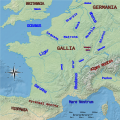 ガリアの地形図(SVG)
 -
 ガリア北東部の地形図(部分、SVG)
 -
 ライン川周辺の地形図(SVG)
 -
 アルモリカの部族分布図
 -
 Britain as triangular island described by Caesar (svg)

.svg)
.svg)
.svg)
.svg)

.svg)

-
 partes navis longae in Roma antiqua
 -
 partes navis longae in Roma antiqua


-

-
-

-

-
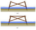 brace version
 -
 brace version
 -
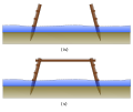
 with crossed stakes


.svg)
.svg)
.svg)
- Roman fortifications; Defensive walls
-
 pinnae loricaeque

-

-
 iter Caesaris in Noviodunum


加工
[edit]
_(1898)_(14778300381)(cropped).jpg)
.jpg)
.png)
内乱記
[edit]Category:Roman Republican civil wars
Category:Julius Caesar crossing the Rubicon
Category:Caesar's Civil War
Category:Battle of Dyrrhachium (48 BC)
-
-

-
 ガイウス・スクリボニウス・クリオのBC49年のアフリカ戦役での関連地図
 -
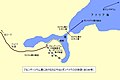
 カエサルのアルバニアにおける戦役図(ラテン語)
 -
 カエサルのアルバニアにおける戦役図(日本語)
 -
 カエサルのアルバニアにおける戦役図(日本語)アポッロニアまで
 -
 ローマ内戦におけるアドリア海の図
 -
 カエリウス・ルフスの武装蜂起関連図
 -
 カエキリウス・メテッルス家の家系図(英語)に、『内乱記』の理解のため、日本語の説明を付加したもの。
 -
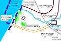
 デュッラキウムの戦いにおけるカエサルの二重の堡塁をめぐるポンペイウス勢との攻防の概略図(ラテン語・日本語)
 -
 デュッラキウムの戦いの終盤におけるレスニキア川の戦いの戦況図(1)(ラテン語と日本語)
 -
 前図のPNG版。
 -
 デュッラキウムの戦いの終盤におけるレスニキア川の戦いの戦況図(2)(ラテン語と日本語)
 -
 デュッラキウムの戦いの終盤におけるレスニキア川の戦いの戦況図(3)(ラテン語と日本語)
 -
 パルサルスの戦い直前のギリシアの地図(ラテン語)
 -
 パルサルスの戦い直前のギリシアの地図(日本語)
 -
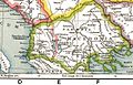
 ローマ内戦(BC48年)における古代ギリシアの地図(日本語)
 -
 ローマ内戦(BC48年)における古代ギリシアの地図(ラテン語)
 -
 ローマ内戦(BC48年)における古代ギリシアの地図(blank)
 -
 ローマ内戦(BC48年)における古代ギリシアの地図(ラテン語)
 -
 ローマ内戦(BC48年)におけるイタリア南部の地図(ラテン語)
 -
 ローマ内戦(BC48年)におけるポンペイウスのエジプトへの逃亡経路図(ラテン語)
 -

-
 プトレマイオス朝時代のアレクサンドリアの地図


.png)
.png)
.png)


_Japanese.jpg)
_Japanese.png)
_Japanese.png)
_Japanese.png)
.png)
.png)
.png)
.png)
.png)
.png)
.png)
_PNG.png)
.png)
.png)
ラテン語・ローマ史の地図
[edit]-
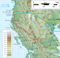
 古代のラティウム周辺の地形図

ラテン語
[edit]-
 fere libenter homines id quod volunt credunt
加工画像
[edit]-
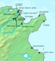
 Roman province of Macedonia
 -
 Roman province of Macedonia
 -

-


.jpg)
.jpg)
アップロードしたパブリックドメイン画像
[edit]-
 デュッラキウムの戦いの配置図
 -
 レスニキア川の戦いの経過図


参考画像&カテゴリ
[edit]◎Category:CommonsRoot(主要カテゴリ)
- Category:Categories(カテゴリを集めたカテゴリ)
- Category:Categories by language(言語別のカテゴリ)
- Category:Files by language used(使用言語別のファイル)
- Category:Language-neutral(言語中立な) - Category:Language-neutral diagrams(言語中立な図)
- Category:Files by language used(使用言語別のファイル)
- Category:Categories by language(言語別のカテゴリ)
- Category:Topics(総記)
- Category:Knowledge(知識)
- Category:Knowledge representation(知識表現)
- Category:Information(情報)
- Category:Visualization(可視化)
- Category:Information graphics(インフォグラフィック - 情報画像)
- Category:Scientific modeling(科学モデリング)
- Category:Knowledge(知識)
- Category:Diagrams(図表・図解:ダイアグラム)
- Category:Diagrams by language(言語別の図表)
- Category:Diagrams by subject(テーマ別の図表)
- Category:Media types(メディアのタイプ)
- Category:Animations(アニメーション)
- Category:Animations by subject(テーマ別のアニメーション)
- Category:Animated maps(地図のアニメーション)
- Category:Animations by subject(テーマ別のアニメーション)
- Category:Animations(アニメーション)
地図の画像
[edit]- Category:Maps(地図)
- Category:Maps by type(タイプ別の地図)
- Category:Maps by language(言語別の地図)
- Category:Language-neutral maps(言語中立な地図)
- Category:Blank maps(白地図)
- Category:Language-neutral maps(言語中立な地図)
- Category:Earth(地球)
- Category:Earth from space(大気圏外から見た地球)
- Category:Earth's atmosphere(地球の大気)
- Category:World(世界)
- Category:Regions(地域)
- Category:Continents(大陸)
- Category:Oceans(大洋) - Category:Bodies of water(水域)- Category:Seas(海)
- Category:Maps of oceans(大洋の地図)
- Category:Regions(地域)
- Category:Mediterranean(w:地中海盆地)
- Category:Mediterranean Sea(地中海)
- Category:Maps of the Mediterranean Sea(地中海の地図)
- Category:Maps of the Mediterranean Basin(地中海盆地の地図)
- Category:Maps of the Adriatic Sea(アドリア海の地図)
- Category:Maps of the Mediterranean Basin(地中海盆地の地図)
- Category:Maps of the Mediterranean Sea(地中海の地図)
- Category:Mediterranean Sea(地中海)
- Category:Maps by century shown(世紀別の地図)
-
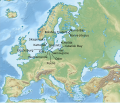
 地中海~近東の白地図 (File:Mediterranean Basin and Near East before 1000 AD locator map.svg)
 -
 地中海~近東の白地図 (File:Blank Roman Empire.png)
 -
 地中海周辺の白地図 (File:Blank map of South Europe and North Africa.svg)


地形図 topographic maps
[edit]-
 地中海~近東の地形図(File:Mediterranean Basin and Near East before 1000 AD topographic map.jpg)
 -
 地中海~近東の地形図(File:Roman Empire Basemap.png)
 -
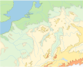
 ヨーロッパの地形図(File:Europe topography map.png)


- SVG topographic maps
古代ガリアの参考画像
[edit]- Category:Blank maps of France(フランスの白地図のカテゴリ)
- Category:SVG blank maps of France(フランスのSVG白地図のカテゴリ)
- Category:Topographic maps of France(フランスの地形図のカテゴリ)
-
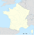
 ブランク地形図
 -
 地域圏境界 ブランク地形図
 -
 地域圏・県境 ブランク地形図
 -
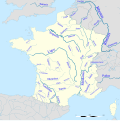
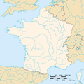
 河川のみ白地図(Lambert図法)
 -
 河川+地域圏 白地図
 -
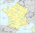
 フランスの河川・地形図(PNG)
 -
 フランスの河川図(PNG)
 -
 フランスの河川図(Mercator図法:SVG)
 -
 フランスの河川図(SVG)
 -
 フランスの河川図(SVG)
 -
 フランスのおもな河川図(PNG)
 -
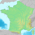
 フランスの地形の概要


.png)


古代ローマの参考画像
[edit]- Category:Topographic maps of Italy(イタリアの地形図のカテゴリ)
- Category:Maps of ancient Latium(古代ラティウムの地図)
-
 イタリアの地形図:州境なし
 -
 前5世紀のラティウム地方


- ライン川の関連図
- Category:Topographic maps of Germany
- Category:Topographic maps of Rhineland-Palatinate
- Category:SVG topographic maps of Germany
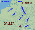
-
 (PNG)
(PNG) -
 (JPG)
(JPG) -
 ゲルマーニアの地形図(SVG)
 -


- Category:Ancient Roman weapons(古代ローマの兵器)
- Category:Reconstructed Roman fortifications of the Muséoparc d'Alésia(アレシア古戦場テーマパークで再現されたローマの城砦)
-
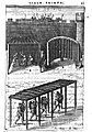 ウィネア(工兵小屋)とプルテウス(障壁車)の想像図
 -
 亀甲車
亀甲車


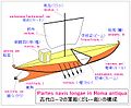
- Category:Navy of ancient Rome(古代ローマの海軍)
-
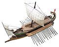 w:三段櫂船の模型

- Category:Family trees of Ancient Rome(古代ローマ人の家系図)
-
 カエキリウス氏族メテッルス家の系図(w:en:Caecilii Metelli family tree)

古代ギリシア
[edit]- Category:Topographic maps of Greece(ギリシアの地形図)
-
 ギリシアの広域白地図(File:Mapa del Mediterrani Oriental.png)
 -
 ギリシアの広域地形図(File:Greece large topographic basemap.svg)
 -
 ギリシアの広域地形図・白地図(File:Greece large topographic blank map.svg)
 -
 ギリシアの地形図(File:MapaTopográficoDeAlbaniaGreciaYElEgeo.svg)


-
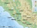
 マケドニアの地形図 (File:Greece (ancient) Macedonia (relief-cropped).png)
 -
 テッサリアの地形図 (File:Greece (ancient) Thessaly (relief-cropped).png)
_Macedonia_(relief-cropped).png)
_Thessaly_(relief-cropped).png)
()
Icons
[edit]
Kanji
[edit]- Category:Radical 070(方)
- Category:Radical 077(止)
- Category:Radical 140(艸)
- Category:Radical 157(足)
- Category:Radical 170(阜;こざとへん)


.png)


-
 𫝂
𫝂 -
 𫝹
𫝹 -
 𫞀
𫞀 -


et cetera
[edit]-
![17世紀のオランダの画家フェルディナント・ボルによって描かれた「フレデリック・スリスケンの肖像」(1652年、油彩、個人所蔵)。画家の妻のはとこに当たる、裕福なワイン商人の息子である8歳少年の肖像画。ロンドンのナショナル・ギャラリーに展示されていた2022年になって「400年前の少年がNikeのロゴ入りのスニーカーを履いていた!」と言い出す人が現われて話題になった。現実には、少年の黒い革靴の光沢のある部分に、窓を通して差し込んだ日射が反射して、あたかもNikeのロゴであるかのように見えたと解釈される。[1]](https://upload.wikimedia.org/wikipedia/commons/thumb/9/9b/Portrait_of_a_Boy%2C_said_to_be_the_artist%27s_son%2C_aged_8_by_Ferdinand_Bol%2C_1652.jpg/101px-Portrait_of_a_Boy%2C_said_to_be_the_artist%27s_son%2C_aged_8_by_Ferdinand_Bol%2C_1652.jpg) 17世紀のオランダの画家フェルディナント・ボルによって描かれた「フレデリック・スリスケンの肖像」(1652年、油彩、個人所蔵)。画家の妻のはとこに当たる、裕福なワイン商人の息子である8歳少年の肖像画。ロンドンのナショナル・ギャラリーに展示されていた2022年になって「400年前の少年がNikeのロゴ入りのスニーカーを履いていた!」と言い出す人が現われて話題になった。現実には、少年の黒い革靴の光沢のある部分に、窓を通して差し込んだ日射が反射して、あたかもNikeのロゴであるかのように見えたと解釈される。[1]
17世紀のオランダの画家フェルディナント・ボルによって描かれた「フレデリック・スリスケンの肖像」(1652年、油彩、個人所蔵)。画家の妻のはとこに当たる、裕福なワイン商人の息子である8歳少年の肖像画。ロンドンのナショナル・ギャラリーに展示されていた2022年になって「400年前の少年がNikeのロゴ入りのスニーカーを履いていた!」と言い出す人が現われて話題になった。現実には、少年の黒い革靴の光沢のある部分に、窓を通して差し込んだ日射が反射して、あたかもNikeのロゴであるかのように見えたと解釈される。[1] -

![17世紀のオランダの画家フェルディナント・ボルによって描かれた「フレデリック・スリスケンの肖像」(1652年、油彩、個人所蔵)。画家の妻のはとこに当たる、裕福なワイン商人の息子である8歳少年の肖像画。ロンドンのナショナル・ギャラリーに展示されていた2022年になって「400年前の少年がNikeのロゴ入りのスニーカーを履いていた!」と言い出す人が現われて話題になった。現実には、少年の黒い革靴の光沢のある部分に、窓を通して差し込んだ日射が反射して、あたかもNikeのロゴであるかのように見えたと解釈される。[1]](/wiki/File:Portrait_of_a_Boy,_said_to_be_the_artist%27s_son,_aged_8_by_Ferdinand_Bol,_1652.jpg)

関連項目 See also
[edit]外部リンク External links
[edit]タグの例 tags
[edit]ファイルの概要
[edit]= {{int:filedesc} } =
| Description |
English: ●英語の説明
日本語: ●日本語の説明 |
| Date | 20●●-●-● (original upload date) |
| Source | Own work based on File:Unmarked map of Albania.png |
| Author | Original uploader was User:Linguae |
| Permission (Reusing this file) |
Released under the GNU Free Documentation License. |
| Other versions | Derivative works of this file: Map of Caesar's campaign in the Roman province of Macedonia to the city of Apollonia (Japanese).png |
Licensing
[edit]={{int:license-header} }=
- {{self|GFDL|cc-by-sa-all} } ⇒「この文書は、フリーソフトウェア財団発行のGNUフリー文書利用許諾書 (GNU Free Documentation License) 1.2またはそれ以降のバージョンの規約に基づき、複製や再配布、改変が許可されます。不可変更部分、表紙、背表紙はありません。このライセンスの複製は、GNUフリー文書利用許諾書という章に含まれています。」
- {{self|cc-by-sa-3.0} } ⇒「この作品の著作権者である私は、この作品を以下のライセンスで提供します。」
- {{PD-old-70-1923} } ⇒「この著作物は、著作権の保護期間が著作者の没後70年以下である国や地域でパブリックドメインの状態にあります。」「この著作物は1923年1月1日より前に発行された(もしくはアメリカ合衆国著作権局に登録された)ため、アメリカ合衆国においてパブリックドメインの状態にあります」
[[Category:Roman Macedonia] ] [[Category:Uploaded with UploadWizard] ]