Category:Wirral Line
Jump to navigation
Jump to search

railway line in Merseyside, England, operated by Merseyrail    | |||||
| Upload media | |||||
| Instance of |
| ||||
|---|---|---|---|---|---|
| Part of |
| ||||
| Location | Merseyside, North West England, England | ||||
| Transport network |
| ||||
| Owned by | |||||
| Operator | |||||
| Train depot | |||||
| |||||
Subcategories
This category has the following 69 subcategories, out of 69 total.
A
- Allport Road bridge (6 F)
B
- Bache railway station (40 F)
- Bebington Road bridge (10 F)
- Bidston Link Road bridge (6 F)
- Birkenhead North TMD (4 F)
- Bromborough Road bridge (6 F)
C
D
- Dunkirk Lane bridge (9 F)
- Dunkirk Way bridge (6 F)
E
- Eastham Rake railway bridge (5 F)
- Ellens Lane bridge (8 F)
- Evans bridge, Spital (3 F)
G
- Green Lane bridge, Tranmere (6 F)
- Green Lane bridge, Wallasey (11 F)
H
L
- Leasowe Road railway bridge (4 F)
- Lincoln Street bridge (6 F)
- Little Sutton railway station (45 F)
M
N
O
- Orrysdale Road footbridge (4 F)
- Overpool railway station (25 F)
P
- Pasture Road bridge (6 F)
R
- Rock Lane West bridge (6 F)
S
- Sandcliffe Road bridge (6 F)
- School Lane bridge, Wallasey (3 F)
- Sea Road bridge (10 F)
- Spital occupation bridge (2 F)
- Spital Road bridge (7 F)
- Storeton Tramway bridge (3 F)
U
W
- West Kirby railway station (26 F)
Media in category "Wirral Line"
The following 25 files are in this category, out of 25 total.
-
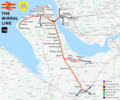 Wirral line.png 2,721 × 2,260; 3.64 MB
-
 Chester to Birkenhead railway - geograph.org.uk - 199427.jpg 480 × 640; 94 KB
-
 Liverpool Line - geograph.org.uk - 35428.jpg 480 × 640; 205 KB
-
 Lower concourse, Moorfields station 3.jpg 5,000 × 3,006; 6.6 MB
-
 Merseyrail Wirral Line Signage Logo.svg 241 × 71; 8 KB
-
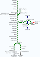 Merseyrail Wirral Line.png 742 × 1,066; 56 KB
-
 Next Wirral Line services from Lime Street.jpg 1,600 × 1,200; 851 KB
-
 Penistone Drive public footpath, Wirral - DSC03403.JPG 3,648 × 2,736; 3.65 MB
-
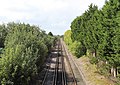
 Railway line passing Bidston Moss - geograph.org.uk - 6194665.jpg 1,024 × 768; 190 KB
-
 Railway towards Eastham Rake - geograph.org.uk - 6349936.jpg 800 × 600; 158 KB
-
 Railway towards New Brighton - geograph.org.uk - 3868073.jpg 640 × 480; 61 KB
-

-
 The Wirral Line - geograph.org.uk - 4654919.jpg 640 × 480; 516 KB
-
 The Wirral Line at Wallasey - geograph.org.uk - 4654829.jpg 640 × 480; 524 KB
-
 View from Pasture Road bridge.jpg 4,739 × 3,359; 16.23 MB
-
 View NW from Lincoln Street bridge.jpg 3,428 × 5,148; 19.79 MB
-
 View SE from Lincoln Street bridge.jpg 3,462 × 5,198; 21.35 MB
-
 View south from Allport Road bridge.jpg 4,728 × 3,219; 21.42 MB
-
 Wirral Line at Meols.JPG 3,648 × 2,736; 3.61 MB
-
 Wirral line from Ross Road footbridge, Ellesmere Port.JPG 4,320 × 3,240; 4.9 MB
-
 Wirral Line map at Lime Street.jpg 1,600 × 1,200; 849 KB
-
 Wirral Line platform at Liverpool Lime Street 01.jpg 1,600 × 1,200; 845 KB
-
 Wirral Line west of Meols station.jpg 4,685 × 2,910; 14.86 MB
-
 Wirral Line, Ledsham 1.JPG 3,648 × 2,736; 3.54 MB
-
 Wirral Line, Ledsham 2.JPG 3,648 × 2,736; 3.57 MB


