Category:Bebington Road bridge
Jump to navigation
Jump to search
| Object location | | View all coordinates using: OpenStreetMap |
|---|
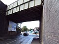
This bridge carries the Wirral Line over Bebington Road to the east of Bebington railway station. It is designated CRR2/47 on the Hooton Junction to Rock Ferry branch (CRR2) of the Chester & Rock Ferry Line and is 12.38 miles from the datum at Chester.
Media in category "Bebington Road bridge"
The following 9 files are in this category, out of 9 total.
-
 Bebington Road bridge 1.jpg 5,061 × 3,396; 11.87 MB
-
 Bebington Road bridge 2.jpg 4,844 × 3,360; 10.47 MB
-
 Bebington Road bridge 3.jpg 4,908 × 3,270; 9.67 MB
-
 Bebington Road bridge 4.jpg 4,431 × 3,117; 9.17 MB
-
 Bebington Road bridge 5.jpg 5,007 × 3,321; 11.19 MB
-
 Bebington Road bridge 6.jpg 4,980 × 3,252; 14.19 MB
-
 Bebington Road bridge 7.jpg 4,878 × 3,192; 10.63 MB
-
 Benchmark at Bebington station bridge.jpg 3,168 × 4,775; 11.38 MB
-
 Rail bridge, Bebington Road.JPG 3,648 × 2,736; 3.64 MB


