Category:Otter Bridge tunnel, Dibbinsdale LNR
Jump to navigation
Jump to search
| Object location | | View all coordinates using: OpenStreetMap |
|---|
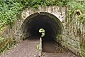
Two tunnels of which one is blocked off as a bat sanctuary take the River Dibbin under the Wirral Line of Merseyrail in Dibbinsdale LNR. The bridge is designated CRR2/38 and is 10.80 miles from the datum at Chester.
Media in category "Otter Bridge tunnel, Dibbinsdale LNR"
The following 11 files are in this category, out of 11 total.
-
 Interior of Otter Bridge tunnel.jpg 4,811 × 3,201; 20.73 MB
-
 Man-made bat cave at Dibbinsdale - geograph.org.uk - 301926.jpg 640 × 480; 72 KB
-
Otters Bridge tunnel echo.mp3 11 s; 411 KB
-
 Otters Tunnel 1.jpg 5,198 × 3,462; 24.4 MB
-
 Otters Tunnel 2.jpg 5,113 × 3,405; 19.97 MB
-
 Otters Tunnel 3.jpg 5,020 × 3,343; 20.23 MB
-
 Otters Tunnel 4.jpg 5,180 × 3,450; 23.66 MB
-
 Otters Tunnel 5.jpg 5,148 × 3,428; 26.44 MB
-
 Underpass, Dibbinsdale - DSC04668.JPG 3,648 × 2,736; 3.54 MB
-
 Vent at Otter Bridge tunnel.jpg 3,388 × 5,091; 25.91 MB
-
 View from above Otter Bridge tunnel.jpg 5,198 × 3,462; 24.88 MB


