Category:Chamberlain Street bridge, Tranmere
Jump to navigation
Jump to search
| Object location | | View all coordinates using: OpenStreetMap |
|---|
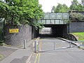
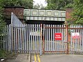
This is bridge CCS1/56 which carries the Wirral Line and disused Birkenhead Dock Branch over Chamberlain Street, Tranmere, Birkenhead. It is 14.24 miles from the datum at Chester.
Media in category "Chamberlain Street bridge, Tranmere"
The following 12 files are in this category, out of 12 total.
-
 Chamberlain Street bridge 1.jpg 5,153 × 3,396; 21.24 MB
-
 Chamberlain Street bridge 2.jpg 5,106 × 3,323; 20.06 MB
-
 Chamberlain Street bridge 3.jpg 4,979 × 3,198; 18.84 MB
-
 Chamberlain Street bridge 4.jpg 5,137 × 3,428; 21.87 MB
-
 Chamberlain Street, Birkenhead (2).JPG 4,320 × 3,240; 4.54 MB
-
 Chamberlain Street, Birkenhead (3).JPG 4,320 × 3,240; 4.37 MB
-
 Chamberlain Street, Birkenhead (4).JPG 4,320 × 3,240; 2.42 MB
-
 Chamberlain Street, Birkenhead (5).JPG 4,320 × 3,240; 3.24 MB
-
 Chamberlain Street, Birkenhead (6).JPG 4,320 × 3,240; 4.2 MB
-
 Chamberlain Street, Birkenhead (7).JPG 3,240 × 4,320; 3.96 MB
-
 Chamberlain Street, Birkenhead (8).JPG 4,320 × 3,240; 3.89 MB
-
 South tunnel Green Lane and Chamberlain Street bridge.jpg 5,118 × 3,345; 19.58 MB


.JPG)
.JPG)
.JPG)
.JPG)
.JPG)
.JPG)
.JPG)
