Category:Spital occupation bridge
Jump to navigation
Jump to search
| Object location | | View all coordinates using: OpenStreetMap |
|---|
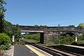
Spital occupation bridge, at the north end of Spital railway station, was built to preserve access to land east of the railway line and (presumably) owned by Spital Old Hall. It carried a roadway over the Wirral Line of Merseyrail; it is CRR2/41 and is 11.26 miles from the datum at Chester.
Media in category "Spital occupation bridge"
The following 2 files are in this category, out of 2 total.
-
 Footbridges, Spital Railway Station (geograph 2986447).jpg 1,024 × 683; 176 KB
-
 Spital Occupation bridge.jpg 4,705 × 3,165; 19.15 MB
.jpg)
