Category:Topographic maps of Thuringia
Jump to navigation
Jump to search
Federal states of Germany:
Subcategories
This category has the following 11 subcategories, out of 11 total.
Media in category "Topographic maps of Thuringia"
The following 33 files are in this category, out of 33 total.
-
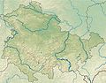 Thuringia relief location map.jpg 1,492 × 1,171; 798 KB
-
 43 of 'Thüringen. Ein geographisches Handbuch, etc' (11216466334).jpg 1,627 × 1,716; 653 KB
-
 Deutschlandbearbeitet von E. von Sydow und Herm. Berghaus Teil Thüringen.jpg 902 × 1,017; 539 KB
-
 Einzugs- und Flussgebietskarte Pleisse.png 777 × 1,233; 1.03 MB
-
 Einzugs- und Flussgebietskarte Saale.png 2,103 × 3,002; 7.24 MB
-
 Einzugs- und Flussgebietskarte Weida.png 553 × 713; 408 KB
-
 Einzugs- und Flussgebietskarte Weisse Elster.png 1,276 × 1,998; 2.86 MB
-

-
 Harz - Deutsche Mittelgebirge, Serie A-de.png 2,450 × 1,300; 4.46 MB
-

-
 Karte der Werrabahn.jpg 1,858 × 2,279; 1.2 MB
-
 Karte des Deutschen Reiches (5820387).jpg 11,526 × 14,270; 66.46 MB
-
 Karte des Deutschen Reiches (5820411).jpg 11,536 × 14,425; 65.44 MB
-
 Karte des Deutschen Reiches (5820412).jpg 11,489 × 14,366; 57.95 MB
-
 Karte des Deutschen Reiches (5820436).jpg 11,455 × 14,115; 70.38 MB
-
 Karte des Deutschen Reiches (5820437).jpg 11,688 × 14,192; 70.06 MB
-
 Karte des Deutschen Reiches (5820438).jpg 11,361 × 14,092; 66.53 MB
-
 Karte des Deutschen Reiches (5820439).jpg 11,487 × 14,017; 65.01 MB
-
 Karte des Deutschen Reiches (5820440).jpg 11,980 × 16,590; 83.75 MB
-
 Karte Verlauf Rennsteig.png 1,500 × 1,040; 2.5 MB
-
 Lange diercke sachsen deutschland bodenverhaeltnisse 2 (Thüringen).jpg 602 × 650; 296 KB
-
 Naturraumkarte Thueringisch-Fraenkisch-Vogtlaendisches Schiefergebirge.png 1,541 × 938; 2.04 MB
-
 Naturraumkarte Thueringisch-Fraenkisches Mittelgebirge mit Vogtland.png 2,111 × 1,693; 4.63 MB
-
 Naturraumkarte Thueringisch-Fraenkisches Schiefergebirge.png 1,033 × 936; 1.38 MB
-
 Naturraumkarte Vogtland.png 1,103 × 938; 1.42 MB
-
 Rhön - Deutsche Mittelgebirge, Serie A-de.png 1,800 × 2,000; 4.92 MB
-
 Thuringia in Germany (relief) (shade) (special marker).svg 1,073 × 1,272; 6.55 MB
-
 Thuringia in Germany (relief) (shade).svg 1,073 × 1,272; 6.52 MB
-
 Thuringia in Germany (relief).svg 1,073 × 1,272; 6.53 MB
-
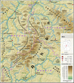
 Thüringer Wald - Deutsche Mittelgebirge, Serie A-de.png 2,200 × 1,850; 5.3 MB
-
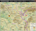 Vierländerregion Bayern - Thüringen - Sachsen - Böhmen DE.png 1,033 × 908; 1.62 MB
-
 Werra Catchment.png 1,200 × 1,462; 3.54 MB
-
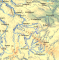 Werra-Zuflüsse topo.png 1,280 × 1,305; 2.72 MB

.jpg)


.jpg)
.jpg)
.jpg)
.jpg)
.jpg)
.jpg)
.jpg)
.jpg)

.jpg)


_(shade)_(special_marker).svg)
_(shade).svg)
.svg)


