Category:Topographic maps of Taiwan
Jump to navigation
Jump to search
Wikimedia category  | |||||
| Upload media | |||||
| Instance of | |||||
|---|---|---|---|---|---|
| Category combines topics | |||||
| |||||
English: The topographic maps of Taiwan.
日本語: 台湾の地形図。
中文(臺灣):臺灣的地形圖。
Media in category "Topographic maps of Taiwan"
The following 44 files are in this category, out of 44 total.
-
 Central part of Taiwan.png 1,107 × 638; 141 KB
-
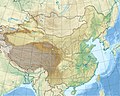 China edcp relief location map.jpg 1,968 × 1,567; 562 KB
-
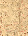
 Dabanlei, Taiwan Hōzu (cropped).jpg 2,285 × 2,845; 2.88 MB
-
 Dabanlei, Taiwan Hōzu.jpg 6,682 × 5,304; 13.97 MB
-
 Distribute map of Taiwan's mountains.png 1,200 × 1,600; 3.25 MB
-
 Guandimiao (Guanmiao), Taiwan Hōzu.jpg 6,696 × 5,216; 15.74 MB
-
 Hengchun, Taiwan Hōzu.jpg 6,708 × 5,271; 15.23 MB
-
 Landform for Kaoh-Ping.png 1,107 × 633; 131 KB
-
 Landform of downtown Kaohsiung.png 1,105 × 633; 110 KB
-
 Landform of Formosa.png 394 × 470; 42 KB
-
 Landform of Kaohsiung City's rural area.png 1,108 × 638; 125 KB
-
 Landform of Kaohsiung's mountain area.png 1,106 × 565; 129 KB
-
 Landform of Kinmen and Matsu.png 1,108 × 636; 66 KB
-
 Landform of northern Taiwan.png 1,063 × 560; 103 KB
-
 Landform of southern Taiwan.png 1,104 × 637; 143 KB
-
 Landform of Taiwan.png 703 × 639; 59 KB
-
 Laolaochaishe, Taiwan Hozu.jpg 6,732 × 5,338; 17.95 MB
-
 Location Ryukyu Islands.PNG 906 × 987; 151 KB
-
 Luodong, Taiwan Hōzu.jpg 6,661 × 5,263; 14.47 MB
-
 Manzhou, Taiwan Hōzu.jpg 6,781 × 5,345; 14.94 MB
-
 Map of Taiwan.jpg 656 × 371; 23 KB
-
 Map台澎.jpg 235 × 296; 15 KB
-
 Mount Zhuzi, Taiwan Hōzu (cropped).jpg 1,456 × 1,815; 1.56 MB
-
 Mount Zhuzi, Taiwan Hōzu.jpg 6,602 × 5,260; 16.68 MB
-
 Niuchongdou, Taiwan Hōzu.jpg 6,650 × 5,290; 13.21 MB
-

-
 Panorama de Kelung Vu de la rade (Croquis No. 5).tif 14,923 × 11,784; 503.14 MB
-
 Shilin, Taiwan Hōzu (cropped).jpg 1,834 × 2,292; 2.02 MB
-
 Shilin, Taiwan Hōzu.jpg 6,833 × 5,331; 16.33 MB
-
 Southern Taiwan (Pingtung's terrain).png 1,108 × 638; 70 KB
-
 Tainan-Kaohsiung-Pingtung.png 1,083 × 564; 116 KB
-
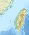 Taiwan relief location map.jpg 1,016 × 1,222; 101 KB
-
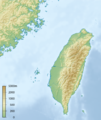 Taiwan relief location map.png 464 × 553; 217 KB
-
 Taiwan'sReliefMap-2.jpg 1,241 × 1,415; 460 KB
-
 Taiwan'sReliefMap-3.jpg 1,241 × 1,415; 456 KB
-
 Terrain of northern Taiwan.png 1,085 × 635; 116 KB
-
 Textile of Tainan-Kaohsiung-Pingtung Metropolitan Area.png 1,081 × 636; 125 KB
-
 Topographic N20E120 5deg.png 885 × 885; 176 KB
-
 Topography of the neighborhood of Fort Santo Domingo 01.png 1,060 × 820; 198 KB
-
 Topography of the neighborhood of Fort Santo Domingo 02.tif 1,120 × 840; 1.64 MB
-
 Tulongwan, Taiwan Hōzu.jpg 6,747 × 5,283; 15.92 MB
-
 Uraisha (Wulaishe), Taiwan Hōzu.jpg 6,725 × 5,371; 11.08 MB
-
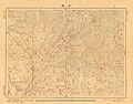
 Yilan, Taiwan Hōzu (cropped).jpg 1,656 × 2,059; 1.62 MB
-
 Yilan, Taiwan Hōzu.jpg 6,641 × 5,241; 14.75 MB


.jpg)


,_Taiwan_H%C5%8Dzu.jpg)


.jpg)


_on_March_27,_1944_(30583362020)_(cropped).jpg)
.jpg)

.png)


,_Taiwan_H%C5%8Dzu.jpg)
.jpg)
