Category:Maps of Hamburg-St. Georg
Jump to navigation
Jump to search
Wikimedia category | |||||
| Upload media | |||||
| Instance of | |||||
|---|---|---|---|---|---|
| Category combines topics | |||||
| St. Georg | |||||
quarter in Hamburg, Germany  Terrasses al carrer Lange Reihe un dia sense pluja  | |||||
| Instance of | |||||
| Location | Hamburg-Mitte, Hamburg, Germany | ||||
| Located in or next to body of water | |||||
| Population |
| ||||
| Area |
| ||||
| Elevation above sea level |
| ||||
| Different from | |||||
 | |||||
Media in category "Maps of Hamburg-St. Georg"
The following 44 files are in this category, out of 44 total.
-
 HH-St. Georg-quarter.jpg 843 × 746; 388 KB
-
 Pincerno - St. Georg - 11-2008.PNG 1,267 × 1,333; 48 KB
-
 St. Georg in HH.svg 1,713 × 1,689; 780 KB
-
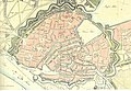
 Hamburg.Karte1320.rekonstruiert.Gaedechen.jpg 5,119 × 3,655; 4.73 MB
-
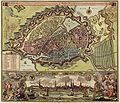 1730 Hamburg Covens & Mortier.JPG 1,321 × 1,132; 1.49 MB
-

-
 Wallhambg.jpeg 1,096 × 725; 714 KB
-
 Hamburg 1790 Elbinseln Varendorf.jpg 3,785 × 2,836; 9.89 MB
-
 Hamburg 1790 große karte varendorf.jpg 7,040 × 3,530; 24.56 MB
-
 Karte hamburg 1790 varendorf kl.jpg 2,000 × 1,003; 1.28 MB
-
 Barmbek1800.png 409 × 459; 19 KB
-
 Hamburgerberg.png 659 × 223; 18 KB
-
 Map hamburg 1800.png 854 × 792; 390 KB
-
 Hamburg.Karte.1813 neddermeyer 300dpi.jpg 5,808 × 4,614; 7.63 MB
-
 Pincerno - Hamburg-Altstadt und Neustadt 1835.jpg 1,232 × 848; 1.67 MB
-
 Hamburg1880Gaedechens.jpeg 8,342 × 6,339; 13.81 MB
-
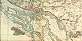
 1890 - Norddeutsche Staaten.jpg 3,170 × 1,825; 5.73 MB
-
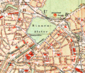
 Hamburg-Plan1890-Ausschnitt.jpg 914 × 956; 835 KB
-
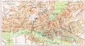
 Innenstadthh.png 714 × 619; 265 KB
-
 Brockhaus and Efron Encyclopedic Dictionary b84 499-0.jpg 3,350 × 2,806; 2.92 MB
-
 Hamburg.Plan.1890 retusche.png 3,000 × 1,622; 2.37 MB
-
 Hamburg.Plan.1890.png 3,000 × 1,622; 2.39 MB
-
 Hamburg 1898 Meyers 5. Aufl..jpg 3,176 × 2,480; 7.3 MB
-
 Meyers b8 s0038a.jpg 3,184 × 2,490; 7.07 MB
-
 Hamburg 1905 Meyers 6. Aufl..jpg 3,193 × 2,479; 7.88 MB
-
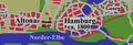
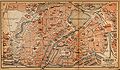
 Map hamburg altona 1910.jpg 2,605 × 1,980; 1.62 MB
-
 Map hamburg inner 1910.jpg 2,091 × 1,219; 956 KB
-
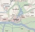
 HamburgKarte Version01 070527 150dpi.PNG 1,641 × 1,319; 862 KB
-
 Aussen-und-binnenalster.png 416 × 642; 288 KB
-
 Karte Außen- und Binnenalster.svg 969 × 1,387; 2.52 MB
-
 Karte Bahnstrecke Lübeck-Hamburg.png 803 × 660; 125 KB
-

-
 Hamburg Mitte St. Georg.svg 311 × 187; 1.37 MB
-
 Pincerno - Hansa-Theater 12-2008.PNG 1,267 × 1,333; 48 KB
-
 Pincerno - Hansaplatz 12-2008.PNG 1,267 × 1,333; 48 KB
-
 Pincerno - Hauptbahnhof 11-2008.PNG 1,267 × 1,333; 48 KB
-
 Pincerno - Horrorhaus.png 1,267 × 1,333; 48 KB
-
 Kartenausschnitt St. Georg 1813.PNG 1,175 × 779; 1.96 MB
-
 Akstgeorg1902-300.jpg 2,031 × 1,443; 1.19 MB
-
 Krankenhaus St. Georg nach dem Umbau 1915 - Lageplan (ZfB 1917).png 2,330 × 1,146; 481 KB
-
 Pincerno - St. Marien 1-2009.PNG 1,267 × 1,333; 48 KB
-
 Pincerno - Hotel Prem - 9-2009.PNG 1,267 × 1,333; 48 KB
-
 Steindamm.png 1,218 × 757; 361 KB
-
 Hamburg Wahlkreis 1.png 1,186 × 1,144; 29 KB


.png)


