Category:Maps of Hainaut (province)
Jump to navigation
Jump to search
Provinces of Belgium: Province of Antwerp · Brussels-Capital Region · East Flanders · Flemish Brabant · Province of Liege · Luxembourg · Province of Namur · Walloon Brabant · West Flanders
Use the appropriate category for maps showing all or a large part of Hainaut. See subcategories for smaller areas:
| If the map shows | Category to use |
|---|---|
| Hainaut on a recently created map | Category:Maps of Hainaut or its subcategories |
| Hainaut on a map created more than 70 years ago | Category:Old maps of Hainaut or its subcategories |
| the history of Hainaut on a recently created map | Category:Maps of the history of Hainaut or its subcategories |
| the history of Hainaut on a map created more than 70 years ago | Category:Old maps of the history of Hainaut or its subcategories |
Subcategories
This category has the following 56 subcategories, out of 56 total.
*
A
- Maps of Anderlues (4 F)
- Maps of Antoing (12 F)
B
- Maps of Belœil, Belgium (2 F)
- Maps of Boussu (5 F)
- Maps of Brunehaut (12 F)
C
- Maps of Celles (Hainaut) (9 F)
- Maps of Colfontaine (6 F)
- Maps of Comines-Warneton (12 F)
- Maps of Courcelles (2 F)
D
- Maps of Dour (10 F)
E
- Maps of Ellezelles (6 F)
- Maps of Erquelinnes (10 F)
- Maps of Estaimpuis (10 F)
- Maps of Estinnes (17 F)
F
- Maps of Flobecq (5 F)
- Maps of Frameries (8 F)
- Maps of Froidchapelle (10 F)
G
- Maps of Gerpinnes (2 F)
H
- Maps of Hensies (8 F)
- Maps of Honnelles (16 F)
L
- Maps of La Louvière (18 F)
- Maps of Lobbes (8 F)
M
- Maps of Momignies (16 F)
- Maps of Mont-de-l'Enclus (8 F)
- Maps of Morlanwelz (6 F)
P
- Maps of Pecq (9 F)
- Maps of Péruwelz (14 F)
- Maps of Pont-à-Celles (2 F)
Q
- Maps of Quévy (15 F)
- Maps of Quiévrain (7 F)
R
- Maps of Rumes (6 F)
S
- Maps of Sivry-Rance (10 F)
T
- Maps of Thuin (13 F)
Pages in category "Maps of Hainaut (province)"
This category contains only the following page.
Media in category "Maps of Hainaut (province)"
The following 32 files are in this category, out of 32 total.
-
 C. 1519 Europe.jpg 4,212 × 3,212; 4.87 MB
-
 Ark 12148 btv1b530427123.jpg 7,907 × 6,107; 11.3 MB
-

-
 ArrMouscron(Moeskroen)Map.png 3,032 × 1,170; 224 KB
-
 ArrMouscronMap-fr.png 3,032 × 1,170; 237 KB
-
 ArrMouscronMap-nl.png 3,032 × 1,170; 232 KB
-
 Belgieheneg.png 398 × 335; 6 KB
-
 Belgium Hainaut location map.svg 763 × 603; 121 KB
-
 BelgiumHainaut.png 398 × 335; 8 KB
-
 Brabant2.png 741 × 537; 192 KB
-
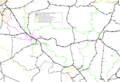 Buurtspoorwegen West-Henegouwen.png 2,946 × 2,008; 1.23 MB
-
 Carrière des Nerviens (alentours)-fr.svg 1,021 × 1,140; 2.27 MB
-
 Charleroi-Thuin.png 530 × 312; 8 KB
-
 Dinant-Philippeville.png 530 × 312; 8 KB
-
 Gemeenten Borinage.png 355 × 278; 8 KB
-
 Gemeenten Thudinië.png 355 × 278; 8 KB
-
 Guicciardini Map of Hainaut.png 1,982 × 1,529; 4.39 MB
-
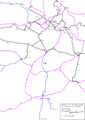 Hainaut centre SNCV names.png 1,456 × 2,050; 480 KB
-
 Hainaut Occidental.jpg 365 × 278; 51 KB
-
 Hainaut1.png 4,104 × 4,372; 181 KB
-
 Henegouwenbevolkingsdichtheid.PNG 578 × 445; 24 KB
-
 HenegouwenBevolkingsgroei18462016.png 578 × 445; 23 KB
-
 HenegouwenBevolkingsgroei19702016.png 578 × 445; 23 KB
-
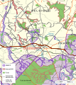
 ParcNaturelTransfrontalierDuHainaut.jpg 2,439 × 1,659; 952 KB
-
 Picardie précis wikipédia.png 4,104 × 4,372; 1.23 MB
-
 Picardie précis222.png 4,104 × 4,372; 1.13 MB
-
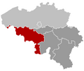
 Province de Hainaut in Belgium.svg 1,136 × 988; 371 KB
-
 Province do Hinnot (eplaeçmint).png 270 × 159; 2 KB
-
 Province of Hainaut (Belgium) location.svg 1,136 × 945; 205 KB
-
 Provinz Hennegau 2019.png 1,136 × 990; 330 KB
-
 Région du Centre (Belgium Belgique).PNG 365 × 281; 9 KB
-
 Soignies 09.jpg 3,648 × 5,472; 6.3 MB


.jpg)


-fr.svg)


.png)
_location.svg)

.PNG)

Map.png)