Category:Locator maps of municipalities in Kreis Wesel
Jump to navigation
Jump to search
Media in category "Locator maps of municipalities in Kreis Wesel"
The following 15 files are in this category, out of 15 total.
-
 Alpen in WES.svg 451 × 483; 309 KB
-
 Dinslaken in WES.svg 451 × 483; 309 KB
-
 Hamminkeln in WES.svg 451 × 483; 309 KB
-
 Hünxe in WES.svg 451 × 483; 309 KB
-
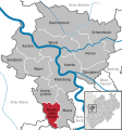
 Kamp-Lintfort in WES.svg 451 × 483; 309 KB
-
 KreisWeselGemeinden.PNG 517 × 498; 44 KB
-
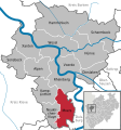 Moers in WES.svg 451 × 483; 309 KB
-
 Municipalities in WES.svg 451 × 483; 597 KB
-
 Neukirchen-Vluyn in WES.svg 451 × 483; 309 KB
-
 Rheinberg in WES.svg 451 × 483; 309 KB
-
 Schermbeck in WES.svg 451 × 483; 309 KB
-
 Sonsbeck in WES.svg 451 × 483; 309 KB
-
 Voerde (Niederrhein) in WES.svg 451 × 483; 309 KB
-
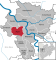
 Wesel in WES.svg 451 × 483; 309 KB
-
 Xanten in WES.svg 451 × 483; 309 KB


_in_WES.svg)

