Category:Locator maps of North Macedonia
Jump to navigation
Jump to search
Subcategories
This category has the following 5 subcategories, out of 5 total.
!
B
Media in category "Locator maps of North Macedonia"
The following 60 files are in this category, out of 60 total.
-
 Bac 1952.svg 512 × 406; 226 KB
-
 Bitola 1952.svg 512 × 406; 226 KB
-
 Bitola Okolija 1952.svg 512 × 406; 65 KB
-
 Budakovo 1952.svg 512 × 406; 226 KB
-
 Bukovo 1952.svg 512 × 406; 226 KB
-
 Debar Okolija 1952.svg 512 × 406; 65 KB
-
 Demir hisar 1952.svg 512 × 406; 226 KB
-
 Dihovo 1952.svg 512 × 406; 226 KB
-
 Dolenci 1952.svg 512 × 406; 226 KB
-
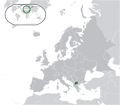
 Europe Balkans Macedonia geo.jpg 726 × 609; 146 KB
-
 Europe location MKD.png 1,600 × 1,200; 711 KB
-
 Europe map macedonia.png 1,231 × 929; 51 KB
-
 Europe-Republic of North Macedonia.svg 2,045 × 1,720; 731 KB
-
 Gevgelija Okolija 1952.svg 512 × 406; 64 KB
-
 Gostivar Okolija 1952.svg 512 × 406; 65 KB
-
 Hircus-Macedonia location Eastern.svg 550 × 421; 405 KB
-
 Hircus-Macedonia location Northeastern.svg 550 × 421; 405 KB
-
 Hircus-Macedonia location Pelagonia.svg 550 × 421; 405 KB
-
 Hircus-Macedonia location Polog.svg 550 × 421; 405 KB
-
 Hircus-Macedonia location Skopje.svg 550 × 421; 405 KB
-
 Hircus-Macedonia location Southeastern.svg 550 × 421; 405 KB
-
 Hircus-Macedonia location Southwestern.svg 550 × 421; 405 KB
-
 Hircus-Macedonia location Vardar.svg 550 × 421; 405 KB
-
 Ivanjevci 1952.svg 512 × 406; 226 KB
-
 Kazani 1952.svg 512 × 406; 226 KB
-
 Kicevo Okolija 1952.svg 512 × 406; 65 KB
-
 Kocani Okolija 1952.svg 512 × 406; 64 KB
-
 Kpalanka Okolija 1952.svg 512 × 406; 64 KB
-
 Kremenica 1952.svg 512 × 406; 226 KB
-
 Kukurecani 1952.svg 512 × 406; 226 KB
-
 Kumanovo Okolija 1952.svg 512 × 406; 64 KB
-
 Location Macedonia Europe.png 2,056 × 1,800; 365 KB
-
 Location map of the Republic of Macedonia.png 500 × 400; 9 KB
-
 LocationMacedonia.png 250 × 115; 6 KB
-
 LocationNorthMacedonia.svg 1,000 × 500; 2.76 MB
-
 Logovardi 1952.svg 512 × 406; 226 KB
-
 Lopatica 1952.svg 512 × 406; 226 KB
-
 Makedonya cb.png 249 × 205; 9 KB
-
 Makovo 1952.svg 512 × 406; 226 KB
-
 Malesevija Okolija 1952.svg 512 × 406; 64 KB
-
 Member States Ratifying North Macedonia NATO Accession Protocol.svg 616 × 247; 519 KB
-
 Mikrosam-europe-macedonia.jpg 225 × 169; 23 KB
-
 MKD muni nonn(Jegunovce in RoM).png 500 × 392; 172 KB
-
 MKD muni nonn(Tetovo in RoM).png 500 × 392; 171 KB
-
 North Macedonia (orthographic projection).svg 553 × 553; 299 KB
-
 Northmacedoniarachelrocket72.jpg 500 × 388; 53 KB
-
 Novaci 1952.svg 512 × 406; 226 KB
-
 Ohrid Okolija 1952.svg 512 × 406; 65 KB
-
 Prespa Okolija 1952.svg 512 × 406; 65 KB
-
 Prilep Okolija 1952.svg 512 × 406; 64 KB
-
 Republic of Macedonia - Location Map (2013) - MKD - UNOCHA.svg 250 × 250; 879 KB
-
 Smilevo 1952.svg 512 × 406; 226 KB
-
 Staravina 1952.svg 512 × 406; 226 KB
-
 Stip Okolija 1952.svg 512 × 406; 64 KB
-
 Strumica Okolija 1952.svg 512 × 406; 64 KB
-
 Tetovo Okolija 1952.svg 512 × 406; 65 KB
-
 Tikves Okolija 1952.svg 512 × 406; 64 KB
-
 Veles Okolija 1952.svg 512 × 406; 64 KB
-
 Velusina 1952.svg 512 × 406; 226 KB
-
 Zvan 1952.svg 512 × 406; 226 KB


.png)
.png)
.svg)


_-_MKD_-_UNOCHA.svg)


