Category:Aerial photographs of Var
Jump to navigation
Jump to search
Departments of Metropolitan France: Ain [01] · Aisne [02] · Allier [03] · Alpes-de-Haute-Provence [04] · Hautes-Alpes [05] · Alpes-Maritimes [06] · Ardèche [07] · Ardennes [08] · Ariège [09] · Aube [10] · Aude [11] · Aveyron [12] · Bouches-du-Rhône [13] · Calvados [14] · Cantal [15] · Charente [16] · Charente-Maritime [17] · Cher [18] · Corrèze [19] · Corse-du-Sud [2A]† · Haute-Corse [2B]† · Côte-d’Or [21] · Côtes-d'Armor [22] · Creuse [23] · Dordogne [24] · Doubs [25] · Drôme [26] · Eure [27] · Eure-et-Loir [28] · Finistère [29] · Gard [30] · Haute-Garonne [31] · Gers [32] · Gironde [33] · Hérault [34] · Ille-et-Vilaine [35] · Indre [36] · Indre-et-Loire [37] · Isère [38] · Jura [39] · Landes [40] · Loir-et-Cher [41] · Loire [42] · Haute-Loire [43] · Loire-Atlantique [44] · Loiret [45] · Lot [46] · Lot-et-Garonne [47] · Lozère [48] · Maine-et-Loire [49] · Manche [50] · Marne [51] · Haute-Marne [52] · Mayenne [53] · Meurthe-et-Moselle [54] · Meuse [55] · Morbihan [56] · Moselle [57] · Nièvre [58] · Nord [59] · Oise [60] · Orne [61] · Pas-de-Calais [62] · Puy-de-Dôme [63] · Pyrénées-Atlantiques [64] · Hautes-Pyrénées [65] · Pyrénées-Orientales [66] · Bas-Rhin [67] · Haut-Rhin [68] · departmental district of the Rhône [69] · Haute-Saône [70] · Saône-et-Loire [71] · Sarthe [72] · Savoie [73] · Haute-Savoie [74] · Paris [75] · Seine-Maritime [76] · Seine-et-Marne [77] · Yvelines [78] · Deux-Sèvres [79] · Somme [80] · Tarn [81] · Tarn-et-Garonne [82] · Var [83] · Vaucluse [84] · Vendée [85] · Vienne [86] · Haute-Vienne [87] · Vosges [88] · Yonne [89] · Territoire de Belfort [90] · Essonne [91] · Hauts-de-Seine [92] · Seine-Saint-Denis [93] · Val-de-Marne [94] · Val-d'Oise [95]
Overseas departments and regions: Guadeloupe [971] · Martinique [972] · French Guiana [973] · Réunion [974] · Mayotte [976]
Overseas collectivities: Saint Pierre and Miquelon [975] · Saint Barthélemy [977] · Wallis and Futuna [986] · French Polynesia [987] · French Southern and Antarctic Lands [984]+
Sui generis territories: New Caledonia [988] · Clipperton Island [989]+
Subcategories
This category has the following 4 subcategories, out of 4 total.
G
- General views of Saint-Tropez (29 F)
S
Media in category "Aerial photographs of Var"
The following 101 files are in this category, out of 101 total.
-
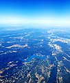 20210711 113850 Lac de Sainte-Croix 01.jpg 3,096 × 3,648; 3.93 MB
-
 20210711 113850 Lac de Sainte-Croix 02.jpg 4,128 × 3,096; 2.79 MB
-
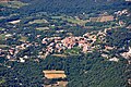
 Aerial view of Ampus.jpg 3,648 × 2,432; 2.01 MB
-
 Aerial view of Camping des Ruisses.jpg 4,056 × 3,040; 7.58 MB
-
 Aerial view of Cavalaire-sur-Mer in the Côte d’Azur region, France (51695657799).jpg 5,464 × 3,640; 16.87 MB
-
 Aerial view of Cavalaire-sur-Mer, France (51694184027).jpg 5,464 × 3,640; 17.37 MB
-
 Aerial view of Les Salles-sur-Verdon 01.jpg 4,056 × 3,040; 4.97 MB
-
 Aerial view of Les Salles-sur-Verdon 02.jpg 4,054 × 1,830; 1.42 MB
-
 Aerial view of Les Salles-sur-Verdon 03.jpg 4,056 × 3,040; 6.54 MB
-
 Aerial view of les Salles-sur-Verdon, camping des Ruisses.jpg 3,911 × 2,635; 2.75 MB
-
 Aerial view of Régusse 01.jpg 3,648 × 2,432; 2.67 MB
-
 Aerial view of Régusse 02.jpg 3,648 × 2,432; 2.75 MB
-
 Aerial view of the bay and harbor of Cavalaire-sur-Mer, France (51695661404).jpg 4,828 × 3,216; 12 MB
-
 Aerial view of the bay of Cavalaire-sur-Mer, France (51695656904).jpg 5,087 × 3,389; 14.1 MB
-
 Aerial view of the beach of Bonporteau in the Côte d’Azur region, France (51695870655).jpg 5,464 × 3,640; 18.9 MB
-
 Aerial view of the beach of Bonporteau on the Côte d’Azur, France (51695658524).jpg 5,137 × 3,422; 19.6 MB
-
 Aerial view of the outlet of the Verdon gorge.jpg 4,056 × 3,040; 7.14 MB
-
 Agay et Anthéor.jpg 3,648 × 2,432; 1.94 MB
-
 Anthéor, aerial view 01.jpg 2,871 × 1,915; 1.08 MB
-
 Anthéor, aerial view 02.jpg 3,648 × 2,432; 2.24 MB
-
 Aq frejus pt-coulombons.jpg 1,280 × 1,440; 369 KB
-
 Aq frejus Pt-Tabaroun.jpg 3,872 × 2,592; 2.56 MB
-
 Aqueduc frejus avion 12.jpg 2,048 × 1,536; 1.21 MB
-
 Aqueduc frejus avion 18.jpg 2,396 × 1,564; 1.65 MB
-
 Aqueduc frejus avion 19.jpg 3,112 × 2,056; 2.24 MB
-
 Aqueduc frejus avion 20.jpg 2,078 × 1,382; 1.31 MB
-
 Aqueduc frejus avion 21.jpg 3,008 × 2,000; 2.17 MB
-
 Aqueduc frejus avion 22.jpg 3,008 × 2,000; 2.2 MB
-
 Aqueduc frejus avion 23.jpg 3,008 × 2,000; 2 MB
-
 Aqueduc frejus avion 24.jpg 2,700 × 1,794; 2.73 MB
-
 Aqueduc frejus avion 25.jpg 2,742 × 1,822; 2.25 MB
-
 Aqueduc frejus avion 26.jpg 3,198 × 2,226; 2.67 MB
-
 Aqueduc frejus avion 27.jpg 3,872 × 2,592; 3.15 MB
-
 Aqueduc frejus avion 28.jpg 2,866 × 2,304; 2.31 MB
-
 Aqueduc frejus avion 29.jpg 3,008 × 2,000; 2.25 MB
-
 Aqueduc frejus avion 30.jpg 2,976 × 2,094; 2.03 MB
-
 Aqueduc frejus avion 31.jpg 2,588 × 1,732; 1.67 MB
-
 Aqueduc frejus avion 32.jpg 3,398 × 2,274; 2.47 MB
-
 Aqueduc Frejus Fondurane Scema.jpg 1,718 × 1,173; 437 KB
-
 Artignosc 007.jpg 4,000 × 2,250; 3.46 MB
-
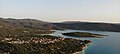
 Baie de Cavalaire (vue aérienne).jpg 3,146 × 2,097; 1.12 MB
-
 Barrage des Cous.jpg 3,648 × 2,432; 2.48 MB
-
 Battleship Strasbourg after bomb attack, 1944.jpg 1,262 × 912; 422 KB
-
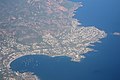
 Bird's eye view of Cavalaire-sur-Mer, France (51695871470).jpg 5,464 × 3,640; 17.07 MB
-
 Canjuers Clos Magnan.jpg 1,586 × 1,201; 830 KB
-
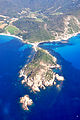
 Cap Camarat (Ramatuelle) - Vue aérienne.jpg 2,295 × 1,507; 781 KB
-
 CapEsterel.jpg 242 × 350; 32 KB
-
 Carqueiranne (1).JPG 1,600 × 1,067; 868 KB
-
 Carrière de la Catalane.jpg 3,648 × 2,432; 2.05 MB
-
 Cavalaire.jpg 1,600 × 1,200; 115 KB
-
 Centre Européen de Modélisme Aérien.jpg 1,000 × 750; 94 KB
-
 Château de Grimaud - Vue aérienne cropped.jpg 913 × 607; 305 KB
-
 Château de Grimaud - Vue aérienne.jpg 1,038 × 925; 273 KB
-
 Circuit Paul Ricard, April 22, 2018 SkySat (cropped).jpg 3,104 × 1,746; 1.97 MB
-
 Circuit Paul Ricard, April 22, 2018 SkySat.jpg 3,885 × 2,185; 3.14 MB
-
 Circuitaerien.jpg 750 × 466; 60 KB
-
 Citadelle de Saint-Tropez (vue aérienne).jpg 3,043 × 2,028; 1.68 MB
-
 Comps 31-12-07.jpg 3,872 × 2,592; 3.18 MB
-
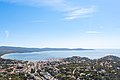
 Côte d’Azur, France (51695294363).jpg 5,327 × 3,549; 15.07 MB
-
 Draguignan centre-ville, vue aérienne.jpg 3,648 × 2,432; 2.73 MB
-
 Flassans vu du ciel.jpg 3,648 × 1,417; 2.73 MB
-
 Flying from La Mole to Cannes-Mandelieu - panoramio - Alistair Cunningham (9).jpg 2,048 × 1,536; 1.29 MB
-
 Flying from La Mole to Cannes-Mandelieu - panoramio - Alistair Cunningham.jpg 2,048 × 1,536; 1.2 MB
-
 Flying from La Mole to Cannes-Mandelieu - panoramio.jpg 2,048 × 1,536; 1.35 MB
-
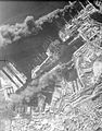 French naval vessels on fire and sinking in the docks at Toulon.jpg 627 × 800; 98 KB
-
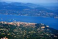 Golfe de Saint-Tropez (vue aérienne).jpg 4,288 × 2,848; 2.91 MB
-
 Grimaud - Vue aérienne (2).jpg 4,288 × 2,848; 2.92 MB
-
 Grimaud - Vue aérienne.jpg 3,096 × 2,088; 1.84 MB
-
 ISS023-E-13740 - View of France.jpg 4,288 × 2,848; 1.63 MB
-
 ISS065-E-20827 - View of Earth.jpg 5,568 × 3,712; 3.57 MB
-
 ISS065-E-20828 - View of Earth.jpg 5,568 × 3,712; 3.14 MB
-
 ISS065-E-20829 - View of Earth.jpg 5,568 × 3,712; 2.79 MB
-
 La Bastide Blanche (Ramatuelle) - Vue aérienne.jpg 2,848 × 4,288; 2.28 MB
-
 La Martre.JPG 3,872 × 2,592; 1.83 MB
-
 Lion de terre.jpg 914 × 613; 73 KB
-
 Massif de la Sainte-Baume.jpg 4,235 × 1,694; 4.79 MB
-
 Mons aero.JPG 1,704 × 2,272; 1.41 MB
-
 Mons, Var).jpg 2,000 × 1,416; 1.45 MB
-
 NH 64855 (19283430270).jpg 4,944 × 4,080; 2.11 MB
-
 Plage de Ramatuelle.jpg 3,468 × 2,312; 817 KB
-
 Pont de Pré-Claou, vue aérienne.jpg 4,724 × 3,531; 2.11 MB
-
 Porquerolles vue du ciel - Anse de la Courtade.JPG 3,648 × 2,736; 2.97 MB
-
 Porquerolles vue du ciel - Pointe Mèdes.JPG 3,648 × 2,736; 2.94 MB
-
 Presqu'île de Giens vue du ciel - Tombolo et salins d'Hyères.JPG 3,648 × 2,736; 3.18 MB
-
 Presqu'île de Saint-Tropez - Vue aérienne (2).jpg 3,793 × 2,528; 989 KB
-
 Presqu'île de Saint-Tropez - Vue aérienne.jpg 4,119 × 2,746; 2.58 MB
-
 Saint-Cassien aero.jpg 1,942 × 1,456; 1.05 MB
-
 Saint-Cassien Barrage EDF.JPG 2,770 × 2,176; 1.94 MB
-
 Saint-Tropez-20160411-06-1 (26139720753).jpg 3,700 × 2,081; 5.42 MB
-
 Siagne pont voie ferree.JPG 3,872 × 2,592; 2.95 MB
-
 St-Cassien-avion.jpg 2,048 × 1,536; 947 KB
-
 Top-down aerial of Brouis Beach, La Croix-Valmer, France (52724208300).jpg 5,464 × 3,640; 19.51 MB
-
 Top-down aerial of the Citadel of Saint-Tropez, France (52724199370).jpg 5,464 × 3,640; 16.23 MB
-
 Top-down view of the beach of Bonporteau on the Côte d’Azur, France (51694187237).jpg 4,938 × 3,290; 16.27 MB
-
 Toulon 1942.jpg 1,512 × 1,183; 429 KB
-
 Vallon Coulombons.JPG 3,872 × 2,592; 2.14 MB
-
 Vallon Larquet.jpg 4,153 × 3,262; 2.85 MB
-
 Vallon Verrerie.jpg 3,872 × 2,592; 3.07 MB
-
 View of Le Beausset.JPG 4,272 × 2,848; 5.88 MB
-
 Village-d-Artigues.jpg 2,560 × 1,920; 649 KB
-
 Vue aerienne de Flassans sur Issole.jpg 800 × 837; 866 KB


.jpg)
.jpg)


.jpg)
.jpg)
.jpg)
.jpg)


.jpg)


.jpg)

_-_Vue_a%C3%A9rienne.jpg)

.JPG)


.jpg)


.jpg)

.jpg)

.jpg)


.jpg)
.jpg)


_-_Vue_a%C3%A9rienne.jpg)


.jpg)
.jpg)


.jpg)


.jpg)


.jpg)
.jpg)
.jpg)


