Category:1920s maps of the Balkans
Jump to navigation
Jump to search
English: This category is intended to collect maps from the 1920s that show multiple Balkan countries in one map frame.
Subcategories
This category has the following 8 subcategories, out of 8 total.
A
- 1920s maps of Albania (2 F)
B
- 1920s maps of Bosnia and Herzegovina (empty)
- 1920s maps of Bulgaria (4 F)
C
G
M
- 1920s maps of Montenegro (1 F)
R
- 1920s maps of Romania (1 F)
S
Media in category "1920s maps of the Balkans"
The following 9 files are in this category, out of 9 total.
-
 Carte des Balkans - btv1b53209935r.jpg 9,446 × 12,121; 19.82 MB
-
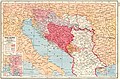 Yugoslavia map 1920.jpg 906 × 600; 192 KB
-

-
 Balkanhalbinsel BV044874971.jpg 4,500 × 3,890; 2.67 MB
-
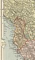 Albania Map (The People's Atlas 1920).jpg 930 × 1,563; 421 KB
-
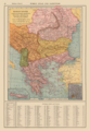 Balkan States and Greater Greece Map 1921 by Francis J Reynolds.png 3,314 × 4,795; 24.2 MB
-

-

-
 Yugo-Slavia, Rumania, Bulgaria and Albania, showing new frontiers - btv1b53065320r.jpg 10,400 × 7,408; 12.01 MB


.jpg)

_(14597752487).jpg)
_-_Historische_alte_Landkarte_(Sammlerst%C3%BCck)_von_1924.jpg)
