Category:1846 maps of New York (state)
Jump to navigation
Jump to search
States of the United States: California · Maryland · Massachusetts · New Jersey · New Mexico · New York · Ohio · Oregon · Pennsylvania · Texas · Utah – Washington, D.C.
Media in category "1846 maps of New York (state)"
The following 9 files are in this category, out of 9 total.
-
 1846 Emmons Agricultural Map of New York State - Geographicus - NewYork-emmons-1846.jpg 4,000 × 3,108; 3.34 MB
-

-

-
 City of New-York - W. Kemble. NYPL434105.tiff 4,127 × 5,033; 59.43 MB
-
 1846 New York gubernatorial election results map by county.svg 921 × 719; 128 KB
-
-
 New York - by H.S. Tanner. NYPL434729.tiff 7,230 × 5,428; 112.28 MB
-
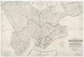
 New York City 1846.jpg 4,784 × 5,797; 4.25 MB
-
 Wade and Croome's panorama of the Hudson River from New York to Albany NYPL433977.tiff 18,853 × 1,054; 56.87 MB


