Category:1720s maps of India
Jump to navigation
Jump to search
Countries of Asia: Armenia‡ · Azerbaijan‡ · People's Republic of China · Cyprus‡ · Egypt‡ · Georgia‡ · India · Indonesia‡ · Iran · Iraq · Japan · Philippines · Russia‡ · Syria · Turkey‡
Limited recognition: Abkhazia‡ · Taiwan · State of Palestine
‡: partly located in Asia
Limited recognition: Abkhazia‡ · Taiwan · State of Palestine
‡: partly located in Asia
Subcategories
This category has the following 3 subcategories, out of 3 total.
- 1721 maps of India (2 F)
- 1726 maps of India (3 F)
Media in category "1720s maps of India"
The following 5 files are in this category, out of 5 total.
-
 Der Jesuiten-Atlas der Kanghsi-Zeit - China und die Aussenlaender LOC 74650033-15.jpg 10,004 × 9,130; 8.59 MB
-
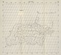 Der Jesuiten-Atlas der Kanghsi-Zeit - China und die Aussenlaender LOC 74650033-15.tif 10,004 × 9,130; 261.32 MB
-

-
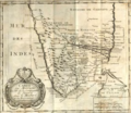 Madurai Mission Map.png 913 × 795; 1.05 MB
-


.jpg)

.jpg)