Category:Old maps of Maine
Jump to navigation
Jump to search
States of the United States: Alabama · Alaska · Arizona · Arkansas · California · Colorado · Connecticut · Delaware · Florida · Georgia · Hawaii · Idaho · Illinois · Indiana · Iowa · Kansas · Kentucky · Louisiana · Maine · Maryland · Massachusetts · Michigan · Minnesota · Mississippi · Missouri · Montana · Nebraska · Nevada · New Hampshire · New Jersey · New Mexico · New York · North Carolina · North Dakota · Ohio · Oklahoma · Oregon · Pennsylvania · Rhode Island · South Carolina · South Dakota · Tennessee · Texas · Utah · Vermont · Virginia · Washington · West Virginia · Wisconsin · Wyoming – District of Columbia: Washington, D.C.
Guam · Northern Mariana Islands · Puerto Rico
Guam · Northern Mariana Islands · Puerto Rico
Subcategories
This category has the following 10 subcategories, out of 10 total.
Media in category "Old maps of Maine"
The following 200 files are in this category, out of 353 total.
(previous page) (next page)-
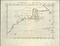 Tierra nveva (NYPL b13868891-484204).jpg 4,776 × 3,646; 3.16 MB
-
 Tierra nveva (NYPL b15307938-434490)(c).jpg 4,160 × 2,912; 1.93 MB
-
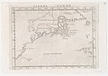
 Tierra nveva (NYPL b15307938-434490).jpg 4,899 × 3,856; 2.54 MB
-
 Tierra nveva (NYPL b15307938-434490).tiff 4,899 × 3,856; 54.08 MB
-
 Tierra nveva. NYPL434490.tiff 5,251 × 4,256; 63.98 MB
-
 Tierra nveva (NYPL b15307937-434500)(c).jpg 4,416 × 3,320; 2.62 MB
-
 Tierra nveva (NYPL b15307937-434500).jpg 5,251 × 4,256; 3.4 MB
-
 Tierra nveva (NYPL b15307937-434500).tiff 5,251 × 4,256; 63.98 MB
-
 A Map of the great river St John - R. Campbell - btv1b53089430j.jpg 5,296 × 6,520; 4.07 MB
-
 A topographical map of Androscoggin County, Maine LOC 2012592363.jpg 16,185 × 15,564; 29.88 MB
-
 A topographical map of Lincoln Co. Maine - from actual surveys LOC 2011589601.jpg 17,628 × 17,280; 35.98 MB
-
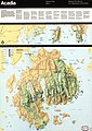
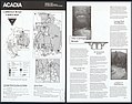 Acadia National Park - carriage road user's map LOC 2002621273.jpg 6,675 × 5,250; 4.26 MB
-
 Acadia National Park - carriage road user's map LOC 2002621273.tif 6,675 × 5,250; 100.26 MB
-
 Acadia National Park and vicinity, Hancock Co., Maine. LOC 73690158.jpg 6,640 × 7,066; 9.51 MB
-
 Acadia National Park and vicinity, Hancock Co., Maine. LOC 73690158.tif 6,640 × 7,066; 134.23 MB
-
 Acadia National Park and vicinity, Hancock Co., Maine. LOC 76695084.jpg 6,682 × 6,896; 9.57 MB
-
 Acadia National Park and vicinity, Hancock Co., Maine. LOC 76695084.tif 6,682 × 6,896; 131.83 MB
-
 Acadia National Park LOC 79695170.jpg 3,887 × 5,018; 3.98 MB
-
 Acadia National Park LOC 79695170.tif 3,887 × 5,018; 55.8 MB
-
 Acadia National Park LOC 80694958.jpg 3,923 × 5,050; 3.05 MB
-
 Acadia National Park LOC 80694958.tif 3,923 × 5,050; 56.68 MB
-
 Acadia National Park, Maine LOC 2001620389.jpg 5,100 × 14,400; 10.32 MB
-
 Acadia National Park, Maine LOC 2001620389.tif 5,100 × 14,400; 210.11 MB
-
 Acadia National Park, Maine LOC 2003620500.jpg 5,250 × 14,400; 10.74 MB
-
 Acadia National Park, Maine LOC 2003620500.tif 5,250 × 14,400; 216.29 MB
-
 Acadia National Park, Maine LOC 2004626416.jpg 5,100 × 14,400; 10.76 MB
-
 Acadia National Park, Maine LOC 2004626416.tif 5,100 × 14,400; 210.11 MB
-
 Acadia National Park, Maine LOC 2005628326.jpg 5,100 × 14,400; 11.2 MB
-
 Acadia National Park, Maine LOC 2005628326.tif 5,100 × 14,400; 210.11 MB
-
 Acadia National Park, Maine LOC 2006628300.jpg 5,100 × 14,400; 10.86 MB
-
 Acadia National Park, Maine LOC 2006628300.tif 5,100 × 14,400; 210.11 MB
-
 Acadia National Park, Maine LOC 2008624219.jpg 5,100 × 14,400; 11.21 MB
-
 Acadia National Park, Maine LOC 2008624219.tif 5,100 × 14,400; 210.11 MB
-
 Acadia National Park, Maine LOC 2009579211.tif 5,100 × 14,400; 210.11 MB
-
 Acadia National Park, Maine LOC 85691483.jpg 4,889 × 6,886; 6.38 MB
-
 Acadia National Park, Maine LOC 85691483.tif 4,889 × 6,886; 96.32 MB
-
 Acadia National Park, Maine LOC 85693184.jpg 5,250 × 14,400; 9.32 MB
-
 Acadia National Park, Maine LOC 85693184.tif 5,250 × 14,400; 216.29 MB
-
 Acadia National Park, Maine LOC 87691006.jpg 8,100 × 14,700; 12.32 MB
-
 Acadia National Park, Maine LOC 87691006.tif 8,100 × 14,700; 340.66 MB
-
 Acadia National Park, Maine LOC 88693017.jpg 5,100 × 14,250; 8.94 MB
-
 Acadia National Park, Maine LOC 88693017.tif 5,100 × 14,250; 207.93 MB
-
 Acadia National Park, Maine, official map and guide LOC 00555619.jpg 5,100 × 14,400; 8.8 MB
-
 Acadia National Park, Maine, official map and guide LOC 00555619.tif 5,100 × 14,400; 210.11 MB
-
 Acadia National Park, Maine, official map and guide LOC 90685103.jpg 5,250 × 14,550; 10.5 MB
-
 Acadia National Park, Maine, official map and guide LOC 90685103.tif 5,250 × 14,550; 218.55 MB
-
 Acadia National Park, Maine, official map and guide LOC 92683225.jpg 5,250 × 14,568; 10.45 MB
-
 Acadia National Park, Maine, official map and guide LOC 92683225.tif 5,250 × 14,568; 218.82 MB
-
 Acadia National Park, Maine, official map and guide LOC 97687080.jpg 5,100 × 14,400; 9.38 MB
-
 Acadia National Park, Maine, official map and guide LOC 97687080.tif 5,100 × 14,400; 210.11 MB
-
 Acadia National Park. LOC 75692041.jpg 3,857 × 5,027; 4.01 MB
-
 Acadia National Park. LOC 75692041.tif 3,857 × 5,027; 55.47 MB
-
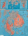
 Administrative map, Maine - February 1993 LOC 93683082.jpg 2,524 × 3,283; 1.18 MB
-
 Administrative map, Maine - February 1993 LOC 93683082.tif 2,524 × 3,283; 23.71 MB
-
 Admiralty Chart No 2487 Portsmouth Harbour (New Hampshire), Published 1857.jpg 8,128 × 5,902; 7.06 MB
-
 Admiralty Chart No 2492 Bay of Fundy to Block Island, Published 1857.jpg 8,130 × 11,946; 7.64 MB
-
 Admiralty Chart No 2670 Halifax to the Delaware, Published 1895, Large Corrections 1928.jpg 16,315 × 11,107; 68.51 MB
-

-
 Bar Harbor, Mt. Desert Island, Maine. LOC 75693240.tif 6,928 × 5,258; 104.22 MB
-
 Bird's eye view of Eastport, Washington Co., Maine. LOC 76695272.jpg 7,696 × 4,880; 7.18 MB
-
 Bird's eye view of Eastport, Washington Co., Maine. LOC 76695272.tif 7,696 × 4,880; 107.45 MB
-
 Bird's eye view of Gardiner and Pittston, Kennebec Co., Maine, 1878 LOC 80693968.jpg 8,608 × 5,904; 11.44 MB
-
 Bird's eye view of Gardiner and Pittston, Kennebec Co., Maine, 1878 LOC 80693968.tif 8,608 × 5,904; 145.4 MB
-
 Bird's eye view of Mechanic Falls, Maine, 1878 - looking east LOC 2015588522.jpg 5,766 × 4,145; 3.81 MB
-
 Bird's eye view of Mechanic Falls, Maine, 1878 - looking east LOC 2015588522.tif 5,766 × 4,145; 68.38 MB
-
 Bird's eye view of the city of Augusta, Maine, 1878 LOC 2007626387.jpg 9,033 × 6,031; 9.96 MB
-
 Bird's eye view of the city of Hallowell, Kennebec Co., Maine 1878. LOC 73694691.jpg 8,240 × 4,592; 6.78 MB
-
 Bird's eye view of the city of Portland, Maine 1876. LOC 75693248.jpg 10,448 × 6,912; 14.9 MB
-
 Bird's eye view of the city of Portland, Maine 1876. LOC 75693248.tif 10,448 × 6,912; 206.61 MB
-
 Birds eye view of Casco Bay, Portland, Maine, and surroundings. LOC 80693592.jpg 8,371 × 6,028; 10.67 MB
-
 Birds eye view of Casco Bay, Portland, Maine, and surroundings. LOC 80693592.tif 8,371 × 6,028; 144.37 MB
-
 Birds eye view of the village of Wiscasset, Lincoln Co., Maine, 1878 LOC 2002621455.jpg 5,008 × 3,583; 3.05 MB
-

-
 Blue Hill, Maine, 1896. LOC 97687303.jpg 7,152 × 4,312; 4.61 MB
-
 Blue Hill, Maine, 1896. LOC 97687303.tif 7,152 × 4,312; 88.23 MB
-
 Boothbay Harbor, Lincoln County, Maine (2675887798).jpg 2,000 × 1,578; 2.49 MB
-
 Boundary, Acadia National Park LOC 96683620.jpg 5,172 × 6,688; 3.34 MB
-
 Boundary, Acadia National Park LOC 96683620.tif 5,172 × 6,688; 98.96 MB
-
 Bridgton, Maine (2675072311).jpg 2,000 × 1,430; 2.49 MB
-
 Bridgton, Maine, U.S.A. - 1888 LOC 83694327.jpg 7,408 × 5,232; 7.63 MB
-
 Bridgton, Maine, U.S.A. - 1888 LOC 83694327.tif 7,408 × 5,232; 110.89 MB
-
 Britannica Maine.jpg 2,001 × 2,858; 2.13 MB
-
 Casco Bay, Maine - DPLA - 5484c39422c32bfd86feec4a9aa95509 (page 1).jpg 12,572 × 8,855; 17.18 MB
-
 Chart of the Coast of Maine, No. 5. - DPLA - 603b54053de2ab1ba937485e383eb912.jpg 9,914 × 6,846; 28.82 MB
-
 Chart of the Coast of Maine, No. 7. - DPLA - f37d3f76da37988307e5e5eb9538e83c.jpg 9,892 × 6,692; 31.18 MB
-
 Chart of the Coast of Maine, No. 8. - DPLA - aab05fccadeac4ffb86d78664502963c.jpg 9,861 × 6,663; 28.15 MB
-
 Chart of the Coast of Maine, No. 9. - DPLA - 7f338ee28595ca38103ca5650c95e184.jpg 9,918 × 6,744; 15.97 MB
-
 Coast of Maine from East Point of Fletchers Neck to Harrington Bay (3045498707).jpg 2,000 × 1,305; 2.45 MB
-
 Coast of Maine from Frenchman Bay to Mosquito Harbor. LOC 77692987.jpg 8,957 × 12,713; 12.56 MB
-
 Coast of Maine from Frenchman Bay to Mosquito Harbor. LOC 77692987.tif 8,957 × 12,713; 325.79 MB
-
 Coast of Maine from Frenchmens Bay to Mosquito Harbor (3046595060).jpg 1,377 × 2,000; 2.26 MB
-
 Coast of Maine from Moose Cove to Gouldsboro Bay (3046534828).jpg 2,000 × 942; 1.28 MB
-
 Coast of Maine from Mosquito Head to Spurwink River (3045761625).jpg 1,382 × 2,000; 2.28 MB
-
 Coast of Maine from Mosquito Head to Spurwink River. LOC 75693430.jpg 8,977 × 12,802; 13.36 MB
-
 Coast of Maine from Mosquito Head to Spurwink River. LOC 75693430.tif 8,977 × 12,802; 328.8 MB
-
 Coast of Maine from Rockland Harbor to Pemaquid Point. LOC 75695812.jpg 8,922 × 12,826; 12.4 MB
-
 Coast of Maine from Rockland Harbor to Pemaquid Point. LOC 75695812.tif 8,922 × 12,826; 327.4 MB
-
 Coast of Maine from Salter Island to Portland Head (3045700993).jpg 2,000 × 1,382; 2.42 MB
-

-

-

-

-
 Coast of New England from Cape Elizabeth, Me. to Newburyport, Mass. LOC 77693970.jpg 6,447 × 8,794; 5.01 MB
-
 Coast of New England from Cape Elizabeth, Me. to Newburyport, Mass. LOC 77693970.tif 6,447 × 8,794; 162.21 MB
-
 Collier's 1921 Maine.jpg 1,974 × 2,416; 1.13 MB
-

-

-

-

-
 CrossIsland NashIsland 40000 1891 304-06-1891 chart.jpg 5,775 × 4,095; 8.47 MB
-
 Dixfield, Maine, 1896. LOC 91685205.jpg 7,984 × 5,792; 6.01 MB
-
 Dixfield, Maine, 1896. LOC 91685205.tif 7,984 × 5,792; 132.3 MB
-
 Dodge's Mount Desert Island LOC 99462701.jpg 4,442 × 4,305; 2.65 MB
-
 Dodge's Mount Desert Island LOC 99462701.tif 4,442 × 4,305; 54.71 MB
-
 EB9 Maine.jpg 2,697 × 3,741; 1.91 MB
-
 Falmouth Harbor (3045761759).jpg 1,472 × 2,000; 2.67 MB
-
 Falmouth Harbour (10295678986).jpg 580 × 800; 88 KB
-
 Falmouth Neck as it was when destroyed by Mowett, Oct. 18, 1775 (7557400886).jpg 7,170 × 5,015; 34.93 MB
-

-
 Flood hazard study program, Maine LOC 81692942.jpg 2,595 × 6,750; 2.24 MB
-
 Flood hazard study program, Maine LOC 81692942.tif 2,595 × 6,750; 50.11 MB
-
 FMIB 33667 Map of the Menhaden Fishing Grounds of Maine.jpeg 772 × 611; 108 KB
-

-
 FMIB 39118 Craig Brook Station, Maine.jpeg 1,935 × 1,657; 615 KB
-
 General soil map Androscoggin and Sagadahoc Counties, Maine. LOC 78692603.jpg 6,545 × 9,256; 6.79 MB
-
 General soil map Androscoggin and Sagadahoc Counties, Maine. LOC 78692603.tif 6,545 × 9,256; 173.32 MB
-
 General soil map Maine LOC 90685328.jpg 5,945 × 8,691; 8.4 MB
-
 General soil map Maine LOC 90685328.tif 5,945 × 8,691; 147.82 MB
-
 GNP Timberland Holdings - 1950.jpg 880 × 1,207; 108 KB
-
 Guide map of Acadia National Park LOC 79693219.jpg 6,858 × 5,536; 6.04 MB
-
 Guide map of Acadia National Park LOC 79693219.tif 6,858 × 5,536; 108.62 MB
-

-

-

-
 Hydrologic unit map-1974, State of Maine. LOC 76695069.jpg 8,684 × 12,696; 15.17 MB
-
 Hydrologic unit map-1974, State of Maine. LOC 76695069.tif 8,684 × 12,696; 315.43 MB
-

-
 J. H. Colton's School Atlas, 1860 - DPLA - 9afa4d40de861bb7b2a7e024bba61c0e (page 13).jpg 4,093 × 4,953; 2.28 MB
-
 Kennebec County, Maine LOC 81690041.jpg 7,375 × 8,996; 6.15 MB
-
 Kennebec County, Maine LOC 81690041.tif 7,375 × 8,996; 189.82 MB
-
 Maine (4584051252).jpg 1,521 × 2,000; 2.87 MB
-
 Maine (NYPL b13692629-1401775).tiff 4,848 × 5,475; 75.96 MB
-
 Maine 1894.jpg 4,749 × 5,756; 2.55 MB
-
 Maine LOC 2011589273.jpg 7,552 × 10,812; 10.25 MB
-
 Maine LOC 2011589273.tif 7,552 × 10,812; 233.61 MB
-
 Maine LOC 2011589342.jpg 4,268 × 5,650; 3.63 MB
-
 Maine LOC 2011589342.tif 4,268 × 5,650; 68.99 MB
-
 Maine LOC 83692119.tif 10,102 × 13,158; 380.29 MB
-
 Maine, Hancock County, Acadia National Park and vicinity. LOC 99446119.jpg 12,920 × 15,280; 25.25 MB
-
 Maine, Hancock County, Acadia National Park and vicinity. LOC 99446119.tif 12,920 × 15,280; 564.82 MB
-
 Maine, soil and water conservation districts LOC 81690088.jpg 5,066 × 6,610; 5.56 MB
-
 Maine, soil and water conservation districts LOC 81690088.tif 5,066 × 6,610; 95.81 MB
-
 Maine, Soil Conservation Service administrative map - January 1991 LOC 92683203.jpg 2,538 × 3,295; 1.11 MB
-
 Maine, Soil Conservation Service administrative map - January 1991 LOC 92683203.tif 2,538 × 3,295; 23.93 MB
-
 Maine, Soil Conservation Service administrative map LOC 81693329.jpg 2,545 × 3,299; 1.08 MB
-
 Maine, Soil Conservation Service administrative map LOC 81693329.tif 2,545 × 3,299; 24.02 MB
-
 Maine, status of flood insurance studies LOC 81690091.jpg 2,595 × 6,750; 2.15 MB
-
 Maine, status of flood insurance studies LOC 81690091.tif 2,595 × 6,750; 50.11 MB
-
 Maine, status of flood insurance studies LOC 81692939.tif 2,595 × 6,750; 50.11 MB
-
 Maine. LOC 99446117.jpg 5,310 × 6,805; 8.39 MB
-
 Maine. LOC 99446117.tif 5,310 × 6,805; 103.38 MB
-

-

-
 Manuscript map of coast from Maine to Delaware (2674786657).jpg 2,000 × 1,696; 2.33 MB
-
-

-
 Map of Badger's Island (1850), Kittery, ME.jpg 800 × 1,074; 248 KB
-
 Map of Bar Harbor, Maine, 1896. LOC 98687157.jpg 9,414 × 6,603; 10.56 MB
-
 Map of Bar Harbor, Maine, 1896. LOC 98687157.tif 9,414 × 6,603; 177.84 MB
-
 Map of Bar Harbor, Maine, 1904. LOC 98687164.jpg 12,202 × 6,784; 9.55 MB
-
 Map of Bar Harbor, Maine, 1904. LOC 98687164.tif 12,202 × 6,784; 236.83 MB
-
 Map of Franklin County, Maine (9136603487).jpg 513 × 800; 107 KB
-
 Map of Kennebec Co., Maine LOC 2012592366.jpg 16,704 × 16,378; 40.24 MB
-
 Map of Lakenwild, Washington County, Maine - owned by Nathan S. Read - 1886 LOC 2009579137.jpg 16,579 × 14,224; 22.73 MB
-

-

-

-

-

-

-
-
 Map of Mount Desert Island and the coast of Maine. LOC 98687176.jpg 6,959 × 4,534; 7.89 MB
-
 Map of Mount Desert Island and the coast of Maine. LOC 98687176.tif 6,959 × 4,534; 90.27 MB
-
 Map of Mount Desert Island, Maine. LOC 98687172.jpg 7,607 × 9,456; 15.08 MB
-
 Map of Mount Desert Island, Maine. LOC 98687172.tif 7,607 × 9,456; 205.8 MB
-
 Map of Mount Desert Island, Maine. LOC 98687177.jpg 7,791 × 9,666; 13.02 MB
-
 Map of Mount Desert Island, Maine. LOC 98687177.tif 7,791 × 9,666; 215.46 MB
-
 Map of Mount Desert Island, Maine. LOC 98687179.jpg 7,152 × 8,666; 8.59 MB
-
 Map of Mount Desert Island, Maine. LOC 98687179.tif 7,152 × 8,666; 177.32 MB
-
 Map of Mount Desert Island. LOC 98687166.jpg 15,319 × 19,342; 48.71 MB
-
 Map of northern Maine - specially adapted to the uses of lumbermen and sportsmen LOC 2010592713.jpg 13,416 × 14,247; 21.68 MB
-
 Map of northern Maine - specially adapted to the uses of lumbermen and sportsmen LOC 2010592713.tif 13,416 × 14,247; 546.85 MB
-
 Map of Piscataquis County, Maine LOC 2012592369.jpg 17,145 × 16,178; 34.15 MB
-
 Map of Piscataquis County, Maine LOC 2012592369.tif 17,145 × 16,178; 793.57 MB
-
 Map of Pond Town Plantation, Maine (10089806583).jpg 620 × 799; 95 KB
-
 Map of Sagadahoc Co., Maine - from actual surveys LOC 2011589603.jpg 15,581 × 17,559; 27.31 MB
-
 Map of Sagadahoc Co., Maine - from actual surveys LOC 2011589603.tif 15,581 × 17,559; 782.74 MB
-
 Map of the city of Augusta, capital of the state of Maine LOC 2008624046.jpg 9,560 × 10,826; 10.42 MB
-
 Map of the city of Augusta, capital of the state of Maine LOC 2008624046.tif 9,560 × 10,826; 296.11 MB
-

.jpg)
(c).jpg)
.jpg)
(c).jpg)
.jpg)


,_Published_1857.jpg)


.jpg)


.jpg)

.jpg)


.jpg)


.jpg)

.jpg)
.jpg)
.jpg)


.jpg)
.jpg)


.jpg)
.jpg)
.jpg)

-_Map_of_Spofford%27s_Brook,_Bucksport,_Me_(2).jpeg)


.jpg)


_(14780106863).jpg)
.jpg)

.jpg)


.jpg)

,_Kittery,_ME.jpg)


.jpg)


.jpg)


.jpg)


_reduced_from_the_original_of_Messrs._Featherstonehaugh_%26_Mudge,_British_commissioners_(8346881914).jpg)