File:"Philip and William Ebling Brewing Company" 1891 map with St. Ann's and Eagle Streets - Bronx, V. 10, Double Page Plate No. 213 - NYPL2001831 (page 1 crop).tiff
Jump to navigation
Jump to search

Size of this JPG preview of this TIF file: 449 × 599 pixels. Other resolutions: 180 × 240 pixels | 360 × 480 pixels | 575 × 768 pixels | 767 × 1,024 pixels | 1,882 × 2,511 pixels.
Original file (1,882 × 2,511 pixels, file size: 13.53 MB, MIME type: image/tiff)
Captions
Captions
Add a one-line explanation of what this file represents
Summary[edit]
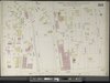
| Description | Bronx, V. 10, Double Page Plate No. 213 [Map bounded by E. 161st St., Clifton St., Trinity Ave., E. 156th St., Elton Ave.]; Atlases of New York city. / Insurance maps of New York. / Bronx / Atlas 42.60. Vol. 10, 1891. | |||||||||||||||||||||||
| Catalogue call number | Map Div. (Sanborn Map Co. Insurance maps of N.Y.) | |||||||||||||||||||||||
| Item/Page/Plate | 213 | |||||||||||||||||||||||
| Date | ||||||||||||||||||||||||
| Source |
http://digitalgallery.nypl.org/nypldigital/dgkeysearchdetail.cfm?imageID=2001831
|
|||||||||||||||||||||||
| Author | Sanborn Map Company -- Publisher | |||||||||||||||||||||||
| Permission (Reusing this file) |
From The Lionel Pincus and Princess Firyal Map Division. http://maps.nypl.org
|
|||||||||||||||||||||||
| Other versions | ||||||||||||||||||||||||
| Location | Stephen A. Schwarzman Building / The Lionel Pincus and Princess Firyal Map Division | |||||||||||||||||||||||
| Digital item published | 5-2-2011 | |||||||||||||||||||||||
| Digital ID | 2001831 | |||||||||||||||||||||||

The making of this file was supported by Wikimedia UK.
To see other files made with the support of Wikimedia UK, please see the category Supported by Wikimedia UK.
|
File history
Click on a date/time to view the file as it appeared at that time.
| Date/Time | Thumbnail | Dimensions | User | Comment | |
|---|---|---|---|---|---|
| current | 01:51, 21 January 2022 |  | 1,882 × 2,511 (13.53 MB) | Ooligan (talk | contribs) | File:Bronx, V. 10, Double Page Plate No. 213 (Map bounded by E. 161st St., Clifton St., Trinity Ave., E. 156th St., Elton Ave.) NYPL2001831.tiff cropped 79 % horizontally, 62 % vertically using CropTool with lossless mode. |
You cannot overwrite this file.
File usage on Commons
The following page uses this file:
File usage on other wikis
The following other wikis use this file:
- Usage on en.wikipedia.org
- Usage on www.wikidata.org