File:A map of the British and French dominions in North America - with the roads, distances, limits, and extent of the settlements, humbly inscribed to the Right Honourable the Earl of Halifax, and the NYPL484185.tiff
Jump to navigation
Jump to search

Size of this JPG preview of this TIF file: 800 × 487 pixels. Other resolutions: 320 × 195 pixels | 640 × 389 pixels | 1,024 × 623 pixels | 1,280 × 778 pixels | 2,560 × 1,557 pixels | 16,233 × 9,872 pixels.
Original file (16,233 × 9,872 pixels, file size: 458.49 MB, MIME type: image/tiff)
Captions
Captions
Add a one-line explanation of what this file represents
Summary[edit]
| Warning | The original file is very high-resolution. It might not load properly or could cause your browser to freeze when opened at full size. |
|---|
| Description | A map of the British and French dominions in North America : with the roads, distances, limits, and extent of the settlements, humbly inscribed to the Right Honourable the Earl of Halifax, and the other Right Honourable the Lords Commissioners for Trade and Plantations / by their Lordships most obliged and very humble servant, Jno. Mitchell ; Tho. Kitchin, sculp.; Lawrence H. Slaughter Collection of English maps, charts, globes, books and atlases / Charts and maps | |||||||||||||||||||||||
| Notes | Relief shown pictorially. ''Note 2.'') Third impression of 1st ed.; shows Worcester, Mass., as distinguished from previous impression. ''Note 3.'') "Sold by And: Millar opposite Katharine Street in the Strand." ''Note 4.'') Outline color. ''Note 5.'') Includes text and inset "A new map of Hudson's Bay and Labrador from the late surveys of those coasts." | |||||||||||||||||||||||
| Catalogue call number | Map Div. 97-6107 [LHS 484, rolled] | |||||||||||||||||||||||
| Standard reference | Ristow. A la carte, p. 10 | |||||||||||||||||||||||
| Date | ||||||||||||||||||||||||
| Source |
http://digitalgallery.nypl.org/nypldigital/dgkeysearchdetail.cfm?imageID=1951054
|
|||||||||||||||||||||||
| Author | Kitchin, Thomas, d. 1784 -- Engraver; Mitchell, John, 1711-1768 -- Cartographer | |||||||||||||||||||||||
| Permission (Reusing this file) |
From The Lionel Pincus and Princess Firyal Map Division. http://maps.nypl.org
|
|||||||||||||||||||||||
| Location | Stephen A. Schwarzman Building / The Lionel Pincus and Princess Firyal Map Division | |||||||||||||||||||||||
| Digital item published | 2-3-2004; updated 3-25-2011 | |||||||||||||||||||||||
| Digital ID | 484185 | |||||||||||||||||||||||

The making of this file was supported by Wikimedia UK.
To see other files made with the support of Wikimedia UK, please see the category Supported by Wikimedia UK.
|
File history
Click on a date/time to view the file as it appeared at that time.
| Date/Time | Thumbnail | Dimensions | User | Comment | |
|---|---|---|---|---|---|
| current | 10:30, 20 April 2014 |  | 16,233 × 9,872 (458.49 MB) | Fæ (talk | contribs) | GWToolset:: Creating mediafile for Fæ. Tranche 2.590 |
| 10:28, 20 April 2014 | 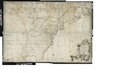 | 16,233 × 9,872 (458.49 MB) | Fæ (talk | contribs) | GWToolset:: Creating mediafile for Fæ. Tranche 2.590 |
You cannot overwrite this file.
File usage on Commons
There are no pages that use this file.