Category:Aerial photographs of Fukui prefecture
Jump to navigation
Jump to search
| Prefectures of Japan | |||
|---|---|---|---|
| Hokkaido | Aomori · Iwate · Miyagi · Akita · Yamagata · Fukushima · Ibaraki · Tochigi · Gunma · Saitama · Chiba · Tokyo · Kanagawa · Niigata · Toyama · Ishikawa · Fukui · Yamanashi · Nagano · Gifu · Shizuoka · Aichi · Mie · Shiga · Kyoto · Osaka · Hyogo · Nara · Wakayama · Tottori · Shimane · Okayama · Hiroshima · Yamaguchi | Tokushima · Kagawa · Ehime · Kōchi | Fukuoka · Saga · Nagasaki · Kumamoto · Ōita · Miyazaki · Kagoshima · Okinawa | 
| ||
Media in category "Aerial photographs of Fukui prefecture"
The following 51 files are in this category, out of 51 total.
-
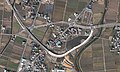
 Aerial photographs of Oi-Takahama interchange.jpg 1,200 × 600; 626 KB
-
 Aerial photographs of Ono interchange, Fukui.jpg 2,000 × 1,200; 1.62 MB
-
 Akao Otsutsumi water reservoir Aerial photograph.1977.jpg 1,138 × 832; 381 KB
-
 Ao-Shima Island Obama, Fukui Aerial Photograph.jpg 1,476 × 1,967; 831 KB
-
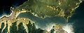 Aoto-no-irie Bay Aerial photograph.1975.jpg 7,883 × 3,055; 17.38 MB
-
 Awara Golf Club, Awara Fukui Aerial photograph.2008.jpg 3,322 × 4,429; 5.63 MB
-
 EC-Eiheiji-guchi Station-Aerial photography 1948.jpg 1,079 × 903; 596 KB
-
 EchizenKaigan.jpg 1,280 × 960; 202 KB
-
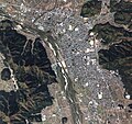
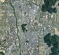
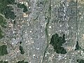
 Fukui city aerial 01.jpg 3,008 × 2,000; 1,010 KB
-
 Fukui city aerial 02.jpg 3,008 × 2,000; 1.2 MB
-
 Fukui city aerial 03.jpg 3,000 × 1,996; 1.4 MB
-
 Fukui city aerial 04.jpg 3,008 × 2,000; 1.2 MB
-
 Fukui city center area Aerial photograph.1975.jpg 6,894 × 6,787; 41.14 MB
-
 Fukui city center area Aerial photograph.2021.jpg 13,839 × 14,999; 155.21 MB
-
 Fukui Prefectural Hospital sky.JPG 2,816 × 2,112; 1.56 MB
-
 Fukui prefectural office sky.JPG 3,648 × 2,736; 5.43 MB
-
 Fukui prison - aerial photograph.jpg 600 × 450; 228 KB
-
 Fukui-Izumi ski resort.jpg 2,177 × 1,156; 2.42 MB
-
 Hakusan Train Depot.jpg 2,308 × 1,536; 906 KB
-
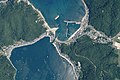
 Hayase aerial photograph 2013.jpg 1,264 × 948; 292 KB
-
 Hiruga aerial photograph 2018.jpg 2,904 × 1,936; 2.06 MB
-
 Jr west fukui station sky.JPG 2,272 × 1,704; 1.53 MB
-
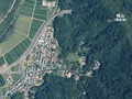
 Katsuyama city center area Aerial photograph.1977.jpg 4,381 × 3,438; 10.7 MB
-
 Katsuyama city center area Aerial photograph.2014.jpg 8,740 × 8,216; 54.24 MB
-
 Kumagawa-juku post town district Aerial photograph.1975.jpg 3,002 × 2,172; 6.7 MB
-
 Kuzuryu Dam Lake Aerial photograph.1977.jpg 8,190 × 4,271; 31.61 MB
-
 Lake Kitagata Lagoon Aerial photograph.2008.jpg 6,142 × 7,644; 15.92 MB
-
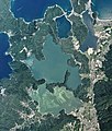
 Mikata five lakes Aerial photograph.1975.jpg 3,427 × 4,999; 11.98 MB
-
 Mikata five lakes Aerial photograph.2018.jpg 11,051 × 12,950; 48.61 MB
-
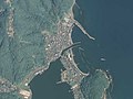
 Mizushima Island Tsuruga, Fukui Aerial Photograph.jpg 1,495 × 1,084; 391 KB
-
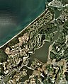
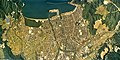
 Obama city center area Aerial photograph.1975.jpg 5,067 × 3,485; 12.55 MB
-
 Obama city center area Aerial photograph.2013.jpg 5,445 × 6,824; 30.15 MB
-
 Obama City General Ground.jpg 1,506 × 1,001; 662 KB
-
 Ohara Dam lake (Katsuyama, Fukui) 1977.jpg 436 × 326; 58 KB
-
 Oi NPP 1975.jpg 1,918 × 1,436; 503 KB
-
 Ono Basin in Winter.jpg 1,530 × 861; 344 KB
-
 Ono, Fukui prefecture city center area Aerial photograph.1977.jpg 5,819 × 5,055; 25.21 MB
-
 Ono, Fukui prefecture city center area Aerial photograph.2014.jpg 8,781 × 8,172; 53.98 MB
-
 Sabae city center area Aerial photograph.1975.jpg 5,527 × 3,575; 14.04 MB
-
 Sabae city center area Aerial photograph.2021.jpg 12,165 × 11,404; 95.73 MB
-
 Sagaki aerial photograph 2018.png 1,613 × 1,206; 4.84 MB
-

-
 Takefu district Echizen city Aerial photograph.1975.jpg 5,288 × 5,494; 25.48 MB
-
 Takefu district Echizen city Aerial photograph.2021.jpg 12,038 × 9,015; 74.3 MB
-
 Tojinbo 2008-04-30.jpg 1,602 × 1,202; 1.71 MB
-
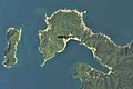
 Tsunegami Peninsula Aerial photograph.1975.jpg 7,181 × 6,626; 20.35 MB
-
 Tsunegami Peninsula Aerial photograph.2013.jpg 5,413 × 6,149; 4.4 MB
-
 Tsunekami fishing port town Aerial photograph.2018.jpg 5,549 × 3,699; 3.67 MB
-
 Tsuruga city center area Aerial photograph.1975.jpg 6,818 × 3,432; 17.11 MB
-
 Tsuruga city center area Aerial photograph.2013.jpg 6,383 × 6,327; 35.86 MB
-
 USA-R68-1-56.jpg 3,937 × 3,779; 1.67 MB


_1977.jpg)


.png)


