File:Alpenkarte.svg
Jump to navigation
Jump to search

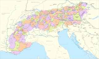
Size of this PNG preview of this SVG file: 800 × 471 pixels. Other resolutions: 320 × 188 pixels | 640 × 377 pixels | 1,024 × 603 pixels | 1,280 × 754 pixels | 2,560 × 1,507 pixels | 3,178 × 1,871 pixels.
Original file (SVG file, nominally 3,178 × 1,871 pixels, file size: 2.42 MB)
Captions
Captions
Add a one-line explanation of what this file represents
Summary
[edit]
| Description |
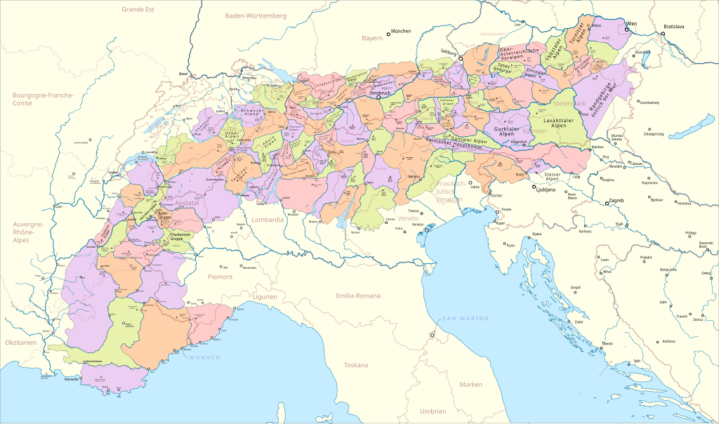
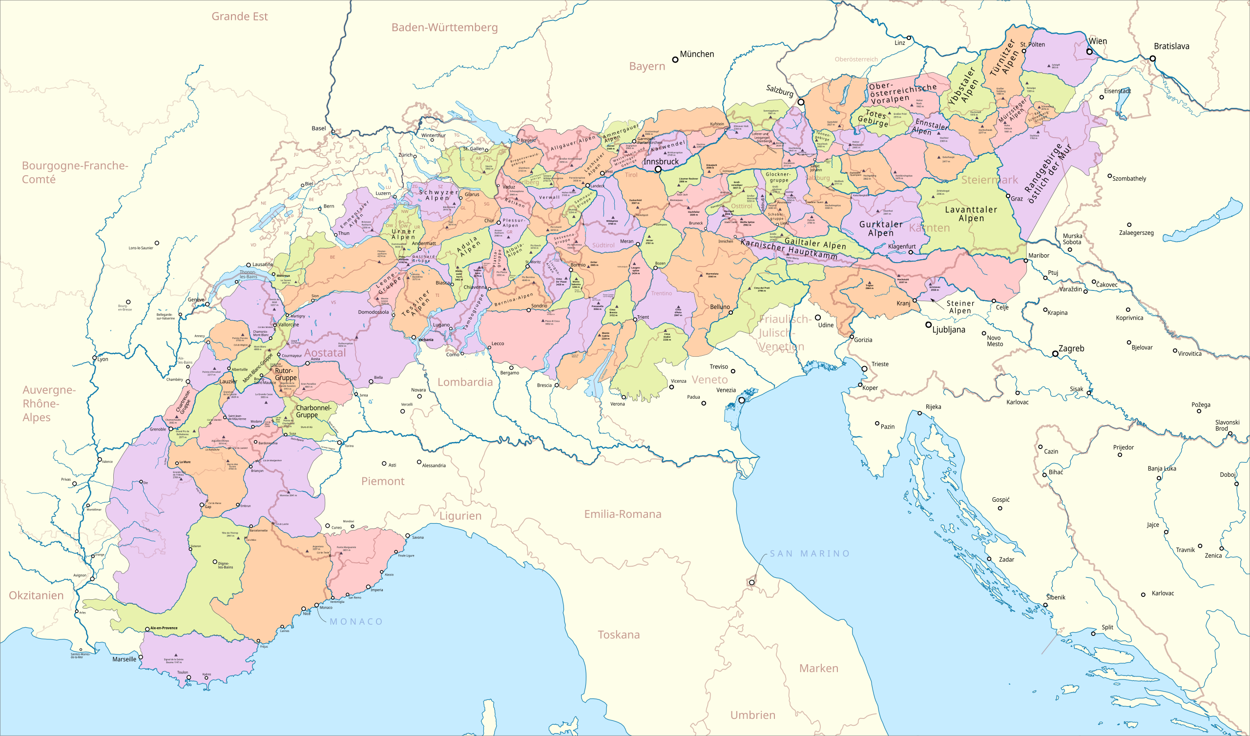
Deutsch: Karte der Gebirgsgruppen in den Alpen. Einteilung nach AVE für die Ostalpen, nach Höhne für die östlichen Westalpen, nach Bergalbum für die westlichen Westalpen. SVG-Version von Karte der Gebirgsgruppen in den Alpen.png |
|||||||||
| Date | ||||||||||
| Source |
Own work Map was created using: |
|||||||||
| Creator | ||||||||||
| Permission (Reusing this file) |
Map data (c) OpenStreetMap (and) contributors, CC-BY-SA | |||||||||
| Geotemporal data | ||||||||||
| Bounding box |
|
|||||||||
| Georeferencing | ||||||||||
This file is licensed under the Creative Commons Attribution-Share Alike 2.0 Generic license.
- You are free:
- to share – to copy, distribute and transmit the work
- to remix – to adapt the work
- Under the following conditions:
- attribution – You must give appropriate credit, provide a link to the license, and indicate if changes were made. You may do so in any reasonable manner, but not in any way that suggests the licensor endorses you or your use.
- share alike – If you remix, transform, or build upon the material, you must distribute your contributions under the same or compatible license as the original.
| This work is licensed under the Open Database License (summary). |
File history
Click on a date/time to view the file as it appeared at that time.
| Date/Time | Thumbnail | Dimensions | User | Comment | |
|---|---|---|---|---|---|
| current | 03:56, 15 November 2019 | | 3,178 × 1,871 (2.42 MB) | Pechristener (talk | contribs) | some issues improved |
| 03:37, 3 October 2019 |  | 3,178 × 1,871 (2.41 MB) | Pechristener (talk | contribs) | Aix-les-Bains repariert | |
| 03:25, 3 October 2019 |  | 3,178 × 1,871 (2.42 MB) | Pechristener (talk | contribs) | more rendering fixes | |
| 03:11, 3 October 2019 |  | 3,178 × 1,871 (2.42 MB) | Pechristener (talk | contribs) | improved version | |
| 01:17, 30 September 2019 |  | 3,178 × 1,871 (2.23 MB) | Pechristener (talk | contribs) | improved | |
| 01:09, 30 September 2019 |  | 3,178 × 1,871 (2.22 MB) | Pechristener (talk | contribs) | improved | |
| 00:24, 30 September 2019 |  | 3,178 × 1,871 (2.21 MB) | Pechristener (talk | contribs) | einige Renderingfehler behoben | |
| 23:32, 28 September 2019 |  | 3,178 × 1,871 (2.22 MB) | Pechristener (talk | contribs) | == {{int:filedesc}} == {{map |Description={{de|1=Karte der Gebirgsgruppen in den Alpen. Einteilung nach AVE für die Ostalpen, nach Höhne für die östlichen Westalpen, nach Bergalbum für die westlichen Westalpen. SVG-Version von {{f|Karte der Gebirgsgruppen in den Alpen.png}}}} |Source ={{own}} Map was created using: *[http://www.openstreetmap.org/ Open Street Map] |Author = *Pechristener |Date =2019-09-29 |Permission =Map data (c) OpenStr... |
You cannot overwrite this file.
File usage on Commons
The following 10 pages use this file:
- Alps
- User:J budissin/Uploads/BiH/2019 November 11-20
- User:J budissin/Uploads/BiH/2019 October 1-10
- User:J budissin/Uploads/BiH/2019 September 21-30
- Category:Alps
- Category:Lakes of the Alps
- Category:Mountain passes in the Alps
- Category:Rivers of the Alps
- Category:Views of Alps from Ain
- Category:Views of Lake Geneva and the Alps from Lausanne
File usage on other wikis
The following other wikis use this file:
- Usage on arz.wikipedia.org
- Usage on ca.wikipedia.org
- Usage on de.wikipedia.org
- Usage on eo.wikipedia.org
- Usage on eu.wikipedia.org
- Usage on fr.wikinews.org
- Usage on ga.wikipedia.org
- Usage on ha.wikipedia.org
- Usage on hu.wikipedia.org
- Usage on ia.wikipedia.org
- Usage on it.wikivoyage.org
- Usage on kab.wikipedia.org
- Usage on oc.wikipedia.org
- Usage on vec.wikipedia.org
- Usage on www.wikidata.org