Category:Utah State Route 294
Jump to navigation
Jump to search
 | number: | (two ninety-four) |
|---|---|---|
| State highways in Utah: | 274 · 275 · 276 · 279 · 280 · 281 · 282 · 284 · 285 · 286 · 287 · 288 · 289 · 290 · 291 · 292 · 293 · 294 · 295 · 296 · 297 · 298 · 299 · 300 · 301 · 302 · 303 · 304 · 305 · 306 · 307 · 308 · 309 · 310 · 311 · 312 · 313 · 314 |
state highway in Provo, Utah, United States  | |||||
| Upload media | |||||
| Instance of | |||||
|---|---|---|---|---|---|
| Location | Provo, Utah County, Utah | ||||
| Transport network | |||||
| Owned by |
| ||||
| Maintained by |
| ||||
| Inception |
| ||||
| Length |
| ||||
 | |||||
English: Media related to Utah State Route 294 (SR-294), a 0.3857 miles (0.6207 km) state highway in eastern Provo, Utah, United States, that runs along East Center Street, from about 1050 East on East Center Street to the Heninger Administration Building of the Utah State Hospital (at about 1450 East). From 1935 to 1963, most of what is now SR-294 was part of Utah State Route 184, the then designation for all of East Center Street.
Subcategories
This category has the following 2 subcategories, out of 2 total.
S
Media in category "Utah State Route 294"
The following 7 files are in this category, out of 7 total.
-
 East from west end of SR-294, Feb 17.jpg 2,592 × 1,944; 2.32 MB
-
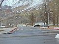 North from east end of SR-294, Feb 17.jpg 2,592 × 1,944; 2.3 MB
-
 South from east end of SR-294, Feb 17.jpg 2,592 × 1,944; 2.37 MB
-
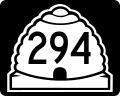 Utah 294.svg 750 × 600; 73 KB
-
 Utah SR 294.svg 385 × 385; 8 KB
-
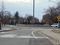 West at roundabout at west end of SR-294, Feb 17.jpg 2,592 × 1,944; 2.44 MB
-
 West from east end of SR-294, Feb 17.jpg 2,592 × 1,944; 2.38 MB


