Category:Utah State Route 184 (1935-1963)
Jump to navigation
Jump to search
former state highway in Provo, Utah, United States  | |||||
| Upload media | |||||
| Instance of | |||||
|---|---|---|---|---|---|
| Location | Provo, Utah County, Utah | ||||
| Transport network | |||||
| Owned by |
| ||||
| Maintained by |
| ||||
| Inception |
| ||||
| Dissolved, abolished or demolished date |
| ||||
| Length |
| ||||
| Terminus |
| ||||
| |||||
English: Media related to Utah State Route 184 (1935-1963), East Center Street, a former 1.3818-mile (2.2238 km) state highway in eastern Provo, Utah, United States, that connected State Route 1 (U.S. Route 50 Alternate / U.S. Route 89 / U.S. Route 91, but now U.S. Route 189) at University Avenue and Center Street, with the Utah State Hospital.
Subcategories
This category has only the following subcategory.
Media in category "Utah State Route 184 (1935-1963)"
The following 6 files are in this category, out of 6 total.
-
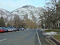 East on Center St from 100 E, Provo, UT, Feb 17.jpg 2,592 × 1,944; 2.26 MB
-
 East on Center St from 700 E, Provo, UT, Feb 17.jpg 2,592 × 1,944; 2.17 MB
-
 Utah 184.svg 750 × 600; 73 KB
-
 Utah SR 184.svg 385 × 385; 8 KB
-
 West on Center St from 1000 E, Provo, UT, Feb 17.jpg 2,592 × 1,944; 2.41 MB
-
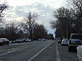 West on Center St from 700 E, Provo, UT, Feb 17.jpg 2,592 × 1,944; 2.39 MB


