Category:Utah State Route 313
Jump to navigation
Jump to search
 | number: | (three hundred thirteen) |
|---|---|---|
| State highways in Utah: | 293 · 294 · 295 · 296 · 297 · 298 · 299 · 300 · 301 · 302 · 303 · 304 · 305 · 306 · 307 · 308 · 309 · 310 · 311 · 312 · 313 · 314 · 315 · 316 · 317 · 318 · 319 · 320 |
state highway in Grand and San Juan counties in Utah, United States   | |||||
| Upload media | |||||
| Instance of | |||||
|---|---|---|---|---|---|
| Location |
| ||||
| Transport network | |||||
| Owned by | |||||
| Maintained by | |||||
| Inception |
| ||||
| Length |
| ||||
| Terminus | |||||
 | |||||
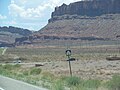
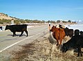
English: Media related to Utah State Route 313, a 22.4679-mile (36.1586 km) state highway in eastern San Juan and Grand counties in Utah, United States, that connects Dead Horse Point State Park with U.S. Route 191 at the mouth of Sevenmile Canyon, about 9 miles (14 km) northwest of Moab.
Subcategories
This category has only the following subcategory.
Media in category "Utah State Route 313"
The following 13 files are in this category, out of 13 total.
-
 La Sal Mountains from Utah State Route 313 Near Moab.jpg 2,048 × 1,536; 414 KB
-
 SR-313 1.jpg 3,264 × 2,448; 4.17 MB
-
 SR-313 2.jpg 3,264 × 2,448; 4.22 MB
-
 US Highway 191 - Utah - 7688634446.jpg 3,072 × 2,304; 545 KB
-
 US Highway 191 - Utah - 7688635314.jpg 3,072 × 2,304; 781 KB
-
 US Highway 191 - Utah - 7688635900.jpg 3,072 × 2,304; 714 KB
-
 UT 313 cattle.jpg 3,186 × 2,337; 1.95 MB
-
 UT-313 descending into Seven Mile Canyon.jpg 3,008 × 2,000; 2.04 MB
-
 Utah 313.svg 750 × 600; 73 KB
-
 Utah Route 313 map.png 1,138 × 852; 32 KB
-
 Utah SR 313.svg 385 × 385; 9 KB
-
 Utah State Route 313 kz01.jpg 4,608 × 2,784; 2.4 MB
-
 View of Utah State Route 313 near the intersection with US 191 20110815 1.jpg 4,731 × 3,032; 4.49 MB


