Category:United Kingdom photographs taken on 2006-04-20
Jump to navigation
Jump to search
| ← | Thursday 20 April 2006 | → | ||
| ← | April 2006 | → | ||

United Kingdom photographs taken on 20 April 2006.
Image files should be categorized here automatically using {{taken on}} template. Direct categorisation is also possible, if automatic is impossible.
Subcategories
This category has only the following subcategory.
S
Media in category "United Kingdom photographs taken on 2006-04-20"
The following 200 files are in this category, out of 378 total.
(previous page) (next page)-
 "The Poachers" at Metal Bridge - geograph.org.uk - 155897.jpg 640 × 480; 53 KB
-
-

-
 1 Hour Film Processing, Killyclogher - geograph.org.uk - 155521.jpg 640 × 630; 150 KB
-
 10 Burghley Road, Peterborough - geograph.org.uk - 155846.jpg 640 × 428; 134 KB
-
-
 A red Devon field - geograph.org.uk - 155708.jpg 480 × 640; 97 KB
-
 A very small pony at East Howle - geograph.org.uk - 155895.jpg 640 × 480; 81 KB
-

-
 A513 at Elford - geograph.org.uk - 156024.jpg 640 × 480; 85 KB
-
 A688 at Metal Bridge - geograph.org.uk - 155911.jpg 640 × 480; 65 KB
-
 A688 near the Hett turn - geograph.org.uk - 155881.jpg 640 × 480; 68 KB
-
 A708 alongside Loch of the Lowes - geograph.org.uk - 156171.jpg 640 × 480; 89 KB
-
 Abandoned Branch Line - geograph.org.uk - 155939.jpg 640 × 480; 92 KB
-
 Afon Dulyn - geograph.org.uk - 157496.jpg 640 × 480; 85 KB
-
 Afon Llugwy - geograph.org.uk - 157089.jpg 640 × 480; 97 KB
-
 Afon Llugwy - geograph.org.uk - 157098.jpg 640 × 480; 103 KB
-
 Afon Porth-llwyd - geograph.org.uk - 157104.jpg 640 × 480; 60 KB
-
 Afon Wygyr 386317.jpg 640 × 480; 123 KB
-
 All Saints, Houghton Regis - geograph.org.uk - 155588.jpg 640 × 480; 62 KB
-
 Ambrose Lane bridge - geograph.org.uk - 155660.jpg 480 × 640; 147 KB
-

-
 Anne Bronte's Grave - geograph.org.uk - 770274.jpg 469 × 640; 264 KB
-
 Ashop Clough - geograph.org.uk - 155854.jpg 640 × 480; 83 KB
-
 At the coal face - geograph.org.uk - 156088.jpg 640 × 480; 65 KB
-
 Beacon of Europe, Ferryhill - geograph.org.uk - 155875.jpg 480 × 640; 97 KB
-
 Bede Terrace, Ferryhill - geograph.org.uk - 155878.jpg 480 × 640; 103 KB
-
 Bend in the River Ashop - geograph.org.uk - 155858.jpg 640 × 480; 117 KB
-
 Bethel Congregational Chapel - geograph.org.uk - 386294.jpg 640 × 480; 63 KB
-
 Birdwood Mission Church - geograph.org.uk - 155495.jpg 640 × 480; 64 KB
-
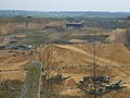 Bishop Middleham Quarry - geograph.org.uk - 155981.jpg 640 × 480; 68 KB
-
 Bishop Middleham village centre.jpg 640 × 480; 76 KB
-
 The 'Black Bull', Rimington - geograph.org.uk - 872945.jpg 640 × 508; 91 KB
-
 Black Forest - geograph.org.uk - 155724.jpg 640 × 480; 111 KB
-
 Bowerhope, St. Mary's Loch.jpg 640 × 480; 72 KB
-
 St. Peter's church, Boxted, Essex - geograph.org.uk - 156227.jpg 640 × 466; 100 KB
-
 Breached dam of Llyn Eigiau - geograph.org.uk - 1702320.jpg 1,600 × 1,200; 450 KB
-
 Brickhouse Farm - geograph.org.uk - 155480.jpg 640 × 480; 77 KB
-
 Brickhouse Wood from Black Forest - geograph.org.uk - 155479.jpg 640 × 480; 124 KB
-
 Broom Road, Ferryhill - geograph.org.uk - 155879.jpg 640 × 480; 64 KB
-
 Buchannan Villas, Killyclogher - geograph.org.uk - 155548.jpg 640 × 478; 65 KB
-
 Bus shelter at Killyclogher, Omagh - geograph.org.uk - 155519.jpg 640 × 479; 80 KB
-
 Cappagh Parish Centre, Killyclogher - geograph.org.uk - 155529.jpg 640 × 479; 66 KB
-
 Castle Grove, Killyclogher - geograph.org.uk - 155556.jpg 640 × 479; 96 KB
-
 Castle Manor, Killyclogher - geograph.org.uk - 155554.jpg 640 × 479; 96 KB
-
 Castleoaks, Killyclogher - geograph.org.uk - 155565.jpg 640 × 479; 96 KB
-
 Cemaes heritage centre - geograph.org.uk - 386297.jpg 640 × 480; 85 KB
-
 Chiltern Green Farmhouse - geograph.org.uk - 155610.jpg 640 × 480; 73 KB
-
 Church Lane Hessenford - geograph.org.uk - 1286885.jpg 480 × 640; 116 KB
-

-
 Coed Bryn-engan - geograph.org.uk - 157094.jpg 640 × 480; 115 KB
-
 Coedty Reservoir - geograph.org.uk - 157478.jpg 640 × 480; 54 KB
-
 Comberford church.jpg 640 × 480; 85 KB
-
 Comberford Hall Drive.jpg 640 × 480; 112 KB
-

-
 Cornforth Lane, Coxhoe (top end) - geograph.org.uk - 155956.jpg 640 × 480; 72 KB
-
 Cornforth Road, Metal Bridge - geograph.org.uk - 155906.jpg 640 × 480; 61 KB
-
 Cornforth Village Green - geograph.org.uk - 155950.jpg 640 × 480; 82 KB
-
 Cornforth Village Green and Church.jpg 640 × 480; 71 KB
-
 Country customs... - geograph.org.uk - 156385.jpg 640 × 420; 95 KB
-

-
 Crick - geograph.org.uk - 155852.jpg 640 × 480; 100 KB
-
 Crick - geograph.org.uk - 156051.jpg 640 × 480; 76 KB
-
 Crook Burn - geograph.org.uk - 159567.jpg 640 × 480; 100 KB
-
 Crook Burn - geograph.org.uk - 159568.jpg 640 × 480; 90 KB
-
 Cycle track behind the A688 - geograph.org.uk - 155890.jpg 640 × 480; 72 KB
-
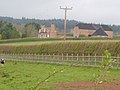
 Daffodil field at Westlake Farm - geograph.org.uk - 155493.jpg 640 × 480; 114 KB
-

-
 Dolgarrog Power Station inflow - geograph.org.uk - 157499.jpg 640 × 480; 88 KB
-
 Dolgarrog Power station outflow - geograph.org.uk - 157502.jpg 640 × 480; 88 KB
-
 Driveway to Broadfields House - geograph.org.uk - 155606.jpg 640 × 480; 103 KB
-
 Driveway to Trimdon House - geograph.org.uk - 156082.jpg 640 × 480; 69 KB
-
 E McGinn and Sons, Killyclogher - geograph.org.uk - 155532.jpg 446 × 600; 45 KB
-
 Easter Cross - geograph.org.uk - 287067.jpg 640 × 333; 99 KB
-
 Eglwys y Santes Fair - geograph.org.uk - 157296.jpg 640 × 480; 125 KB
-
 Elford Bridge - geograph.org.uk - 155612.jpg 640 × 480; 90 KB
-
 Enclosed land at Eilio - geograph.org.uk - 1702352.jpg 1,600 × 1,200; 387 KB
-
 Farmhill Road, Omagh - geograph.org.uk - 155513.jpg 640 × 479; 112 KB
-

-
 Fife way pointer - geograph.org.uk - 166863.jpg 640 × 480; 319 KB
-
 Final Approach - geograph.org.uk - 155618.jpg 640 × 480; 48 KB
-
 Fishburn Colliery Memorial - geograph.org.uk - 156085.jpg 640 × 480; 77 KB
-
 Flank of Moel Eilio - geograph.org.uk - 157471.jpg 640 × 480; 71 KB
-
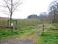
 Footpath crosses road - geograph.org.uk - 225154.jpg 640 × 480; 76 KB
-
 Forest Gate aka Arch Lodge - geograph.org.uk - 155743.jpg 640 × 480; 98 KB
-
 Gates at Knock-na-moe Bungalows - geograph.org.uk - 155546.jpg 640 × 479; 122 KB
-
 Glasgow Central Platforms.JPG 1,536 × 1,024; 510 KB
-
 Gleannan Park, Killyclogher - geograph.org.uk - 155549.jpg 640 × 479; 57 KB
-
 Glendore Wood, Killyclogher - geograph.org.uk - 155552.jpg 640 × 479; 77 KB
-
 Goukhill Farm - geograph.org.uk - 407227.jpg 640 × 427; 95 KB
-
 Green Lane by Church Brake - geograph.org.uk - 155705.jpg 640 × 480; 122 KB
-
 Green lane near Starcross - geograph.org.uk - 155685.jpg 640 × 480; 100 KB
-
 Gulliford - geograph.org.uk - 155484.jpg 640 × 480; 145 KB
-
 Halsteads Farm, Rimington - geograph.org.uk - 1679638.jpg 2,080 × 1,608; 957 KB
-
 Harbour at Haun on Eriskay. - geograph.org.uk - 855330.jpg 640 × 435; 99 KB
-
 Helwell Farm from Kenton Common - geograph.org.uk - 155716.jpg 640 × 480; 101 KB
-
 Hertfordshire Golf and Country Club House - geograph.org.uk - 156055.jpg 640 × 480; 124 KB
-
 Hett Mill - geograph.org.uk - 155899.jpg 640 × 480; 64 KB
-
 High Road Avenue, Bishop Middleham - geograph.org.uk - 155978.jpg 640 × 480; 74 KB
-
 High Street, Cemaes - geograph.org.uk - 386290.jpg 640 × 480; 69 KB
-
 Highland cattle, High Butterby Farm - geograph.org.uk - 156440.jpg 640 × 480; 98 KB
-
 Horses at Mynydd Mechell - geograph.org.uk - 171939.jpg 640 × 480; 75 KB
-

-
 Jerwsalem - geograph.org.uk - 157904.jpg 640 × 480; 84 KB
-
 Kings School, Peterborough.jpg 640 × 428; 160 KB
-
 Knock-na-moe Bungalows, Killyclogher - geograph.org.uk - 155544.jpg 640 × 479; 103 KB
-
 Knock-na-moe, Omagh - geograph.org.uk - 155578.jpg 640 × 288; 53 KB
-
 Laburnum Farm - geograph.org.uk - 155613.jpg 640 × 480; 81 KB
-
 Lane above Starcross - geograph.org.uk - 155643.jpg 640 × 480; 119 KB
-
 Lane near Kenton - geograph.org.uk - 155475.jpg 640 × 480; 141 KB
-
 Lane near Vennbridge Cottage - geograph.org.uk - 155690.jpg 640 × 480; 139 KB
-
 Langham village sign, Essex - geograph.org.uk - 156194.jpg 640 × 480; 99 KB
-
 Lay-by on Harrap Hill - geograph.org.uk - 156083.jpg 640 × 480; 65 KB
-
 Lea Bridge Corner - geograph.org.uk - 155631.jpg 640 × 480; 80 KB
-
 Lea Valley - East Hyde - geograph.org.uk - 155635.jpg 640 × 480; 105 KB
-
 Leat - geograph.org.uk - 157473.jpg 640 × 480; 79 KB
-
 Lichfield Road, Cornforth - geograph.org.uk - 155949.jpg 640 × 480; 65 KB
-
 Liquidising asset - geograph.org.uk - 157441.jpg 640 × 426; 66 KB
-

-
 Llyn Eigiau dam - geograph.org.uk - 1702333.jpg 1,600 × 1,200; 657 KB
-
 Longthorpe Tower1.jpg 428 × 640; 128 KB
-
 M25 at Egham - geograph.org.uk - 155651.jpg 640 × 445; 103 KB
-

-
 McIvor Villas, Omagh - geograph.org.uk - 155517.jpg 640 × 479; 76 KB
-
 Mistley Towers, Mistley, Essex - geograph.org.uk - 158444.jpg 640 × 463; 71 KB
-
 Moorland - geograph.org.uk - 157107.jpg 640 × 480; 57 KB
-
 Mynydd Mechell - geograph.org.uk - 157518.jpg 640 × 480; 78 KB
-
 New River - geograph.org.uk - 156029.jpg 640 × 480; 102 KB
-
 Nicky Line - geograph.org.uk - 155654.jpg 480 × 640; 160 KB
-
 Nicky Line Halt - geograph.org.uk - 155676.jpg 480 × 640; 145 KB
-
 No.2 Monastery Street - geograph.org.uk - 156422.jpg 640 × 406; 93 KB
-
 Nonington Parish Church - geograph.org.uk - 156376.jpg 640 × 521; 122 KB
-
 Northern Ireland Electricity, Omagh - geograph.org.uk - 155512.jpg 640 × 479; 90 KB
-
 Oakland Road, Killyclogher - geograph.org.uk - 155561.jpg 640 × 479; 86 KB
-
 Oakland Villas, Killyclogher - geograph.org.uk - 155558.jpg 640 × 479; 84 KB
-
 Old Mountfield Road, Killyclogher - geograph.org.uk - 155567.jpg 640 × 479; 105 KB
-

-
 Outflow from Coedty Reservoir - geograph.org.uk - 157484.jpg 640 × 480; 81 KB
-
 Park Avenue, Parkhill - geograph.org.uk - 156444.jpg 640 × 480; 63 KB
-
 Periwinkle Hall, Perry Green, Essex - geograph.org.uk - 155766.jpg 640 × 451; 60 KB
-
 64 Thorpe Road, Peterborough - geograph.org.uk - 166970.jpg 640 × 428; 106 KB
-
 Pinefield, Killyclogher - geograph.org.uk - 155551.jpg 640 × 479; 80 KB
-
 Poldark Mine Underground Post Box - geograph.org.uk - 310111.jpg 427 × 640; 81 KB
-
 Poldark Tin Mine - geograph.org.uk - 310106.jpg 640 × 393; 128 KB
-
 Pond at Mowlish - geograph.org.uk - 155490.jpg 480 × 640; 140 KB
-
 Portree High School - geograph.org.uk - 157097.jpg 640 × 427; 133 KB
-
 Portree Masonic Hall - geograph.org.uk - 157103.jpg 640 × 426; 161 KB
-
 Pure Indulgence, Killyclogher - geograph.org.uk - 155525.jpg 640 × 493; 97 KB
-

-
 Richmond Park, Killyclogher - geograph.org.uk - 155540.jpg 640 × 479; 95 KB
-
 Rimington Lane near Rimington Bridge - geograph.org.uk - 872955.jpg 640 × 480; 103 KB
-
 River Browney - geograph.org.uk - 155867.jpg 640 × 480; 76 KB
-
 River Tees - geograph.org.uk - 158559.jpg 640 × 480; 83 KB
-
 River Tees - geograph.org.uk - 158582.jpg 640 × 480; 95 KB
-
 River Tees - geograph.org.uk - 158590.jpg 640 × 480; 95 KB
-
 River Tees - geograph.org.uk - 159195.jpg 640 × 480; 71 KB
-
 Rough ground and exposed bedrock - geograph.org.uk - 157490.jpg 640 × 480; 68 KB
-
 Row of trees on the summit of Harrap Hill - geograph.org.uk - 155992.jpg 480 × 640; 131 KB
-
 Salters Bridge - geograph.org.uk - 155608.jpg 640 × 480; 78 KB
-
 Saltfleetby St.Peter old church - geograph.org.uk - 155803.jpg 427 × 640; 107 KB
-

-
 Shops at Cemaes - geograph.org.uk - 386309.jpg 640 × 480; 80 KB
-
 Short Tunnel - geograph.org.uk - 155940.jpg 640 × 480; 108 KB
-
 Sleights Cricket Club.jpg 640 × 480; 59 KB
-
 Solent - panoramio.jpg 2,048 × 1,536; 820 KB
-
 Southfields, Dedham, Essex - geograph.org.uk - 156954.jpg 640 × 480; 73 KB
-
 Spoil heaps on Eastcott Down - geograph.org.uk - 1066864.jpg 640 × 480; 120 KB
-

-
-
 St Laurence Church and graveyard Wormley - geograph.org.uk - 156038.jpg 640 × 480; 118 KB
-
 St Mary's RC Church, Killyclogher - geograph.org.uk - 155536.jpg 640 × 479; 77 KB
-
 St Mary's Road, Killyclogher - geograph.org.uk - 155537.jpg 640 × 479; 74 KB
-
 St Peter's - geograph.org.uk - 155912.jpg 640 × 480; 85 KB
-
 St. George of England, Toddington - geograph.org.uk - 155587.jpg 640 × 480; 67 KB
-
 St. Mary's church, Langham, Essex - geograph.org.uk - 156281.jpg 640 × 473; 78 KB
-
 St. Mary's church, Lawford, Essex - geograph.org.uk - 158427.jpg 640 × 480; 77 KB
-
 St. Pancras Church, Coldred - geograph.org.uk - 156289.jpg 640 × 426; 138 KB
-
-
 St.Botolph's church, Skidbrooke - geograph.org.uk - 155818.jpg 640 × 427; 77 KB
-
 Stagnant pool near Lysdon Well - geograph.org.uk - 157176.jpg 640 × 480; 82 KB
-
 Stankill Beck at Rimington Bridge - geograph.org.uk - 872948.jpg 640 × 480; 108 KB
-

-
-
 Stryd y Bont - geograph.org.uk - 386303.jpg 640 × 480; 77 KB
-
 Suburban Housing Broxbourne Herts - geograph.org.uk - 156006.jpg 640 × 480; 86 KB
-
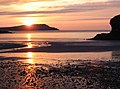 Sunset at Cemaes Bay - geograph.org.uk - 158740.jpg 640 × 474; 73 KB
-
 Swift Studio, Killyclogher - geograph.org.uk - 155523.jpg 640 × 444; 85 KB
-
 Switchback - geograph.org.uk - 155616.jpg 640 × 480; 93 KB
-
 Tabular Hills, North Yorkshire Moors - geograph.org.uk - 218258.jpg 640 × 360; 62 KB
-
 Telephone kiosk, Frogham - geograph.org.uk - 157407.jpg 640 × 426; 141 KB
-
 Temple Ewell Parish Hall.jpg 426 × 640; 117 KB
-
 Thatched cottage near Frogham - geograph.org.uk - 157404.jpg 640 × 426; 76 KB
-
 Thatched estate lodge, Frogham.jpg 640 × 426; 109 KB
-
 The A257 through Wingham - geograph.org.uk - 156402.jpg 640 × 426; 67 KB
-
 The Asylum's taken over the lunatics - geograph.org.uk - 156418.jpg 640 × 426; 106 KB
-
 The Clock Tower Cafe, Scarborough - geograph.org.uk - 770257.jpg 480 × 640; 146 KB
-
 The David Hughes Village Hall - geograph.org.uk - 386298.jpg 480 × 640; 59 KB
-
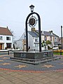
 The Fountain at Mistley, Essex - geograph.org.uk - 158474.jpg 640 × 480; 72 KB
-
 The Gate House to St. Augustine's Abbey - geograph.org.uk - 156424.jpg 426 × 640; 111 KB
-
 The Glen Cafe, Yarrow Valley - geograph.org.uk - 1113980.jpg 640 × 480; 73 KB


_-_geograph.org.uk_-_155956.jpg)


