Category:United Kingdom photographs taken on 2006-04-13
Jump to navigation
Jump to search
| ← | Thursday 13 April 2006 | → | ||
| ← | April 2006 | → | ||

United Kingdom photographs taken on 13 April 2006.
Image files should be categorized here automatically using {{taken on}} template. Direct categorisation is also possible, if automatic is impossible.
Subcategories
This category has only the following subcategory.
S
Media in category "United Kingdom photographs taken on 2006-04-13"
The following 200 files are in this category, out of 327 total.
(previous page) (next page)-
 "Zebra" Lay-By - geograph.org.uk - 151364.jpg 640 × 479; 129 KB
-
 'Caves' of Kilhern - geograph.org.uk - 154852.jpg 480 × 640; 115 KB
-
 A1 near Ellingham - geograph.org.uk - 152850.jpg 640 × 480; 122 KB
-
-
 Abandoned Winch, Heylor, Shetland - geograph.org.uk - 152556.jpg 640 × 480; 113 KB
-
 Access road to Redmarshall Reservoirs - geograph.org.uk - 151453.jpg 640 × 480; 71 KB
-
 Accident - geograph.org.uk - 578632.jpg 640 × 480; 94 KB
-
 Africa House - geograph.org.uk - 151371.jpg 640 × 480; 84 KB
-

-
 Alpines in the Davies Alpine House - geograph.org.uk - 154779.jpg 640 × 480; 163 KB
-
 Badger Hall - geograph.org.uk - 157562.jpg 640 × 411; 89 KB
-
 Barn near Sheldon - geograph.org.uk - 151224.jpg 640 × 480; 49 KB
-
 Beaulieu duck near the sluice gates - geograph.org.uk - 156414.jpg 640 × 480; 106 KB
-
 Bend on A6108 - geograph.org.uk - 154010.jpg 480 × 640; 81 KB
-
 Bight of Braewick, Shetland - geograph.org.uk - 152248.jpg 640 × 480; 77 KB
-
 Black Bull Inn, Frosterley - geograph.org.uk - 151261.jpg 640 × 480; 109 KB
-
 Bolehill Farm - geograph.org.uk - 151222.jpg 640 × 480; 82 KB
-
 Bootle Town Hall, Oriel Road. - geograph.org.uk - 157486.jpg 640 × 480; 60 KB
-
 Bottor Rock - geograph.org.uk - 151513.jpg 640 × 480; 150 KB
-
 Bough Beech Reservoir - geograph.org.uk - 151918.jpg 640 × 480; 124 KB
-
 Bough Beech Reservoir Nature Reserve - geograph.org.uk - 153148.jpg 640 × 462; 93 KB
-
 Bough Beech Visitor Centre - geograph.org.uk - 151932.jpg 640 × 480; 86 KB
-
 Bradley Pond - geograph.org.uk - 151511.jpg 640 × 480; 122 KB
-
 Bradley Pond - geograph.org.uk - 151525.jpg 640 × 480; 71 KB
-
 Braewick Cottage, Braewick, Shetland - geograph.org.uk - 152608.jpg 640 × 480; 107 KB
-
 Bramhope Cemetery - geograph.org.uk - 691336.jpg 640 × 480; 108 KB
-

-
 Bridleway at Finlake - geograph.org.uk - 151517.jpg 480 × 640; 158 KB
-
 Bridleway near Hennock - geograph.org.uk - 151523.jpg 480 × 640; 156 KB
-

-

-
 Buckton Dovecote - geograph.org.uk - 151488.jpg 640 × 480; 114 KB
-
 Building on road junction - geograph.org.uk - 151500.jpg 640 × 480; 130 KB
-
 Burlescombe, near Penslade Farm - geograph.org.uk - 151348.jpg 640 × 427; 138 KB
-
 Carwood Gardens - geograph.org.uk - 151588.jpg 640 × 480; 102 KB
-
 Cattle at Johnson Lane Farm - geograph.org.uk - 151225.jpg 640 × 480; 78 KB
-

-
 Church at Abergwyngregyn - geograph.org.uk - 151496.jpg 640 × 480; 164 KB
-
 Church at Stanhope - panoramio.jpg 2,048 × 1,536; 613 KB
-
 Church of St Maurice.jpg 1,280 × 960; 321 KB
-
 Churchyard Cross - geograph.org.uk - 153058.jpg 427 × 640; 99 KB
-
 Cloister of Beaulieu Abbey.jpg 640 × 480; 168 KB
-
 Collafirth Pier, Shetland - geograph.org.uk - 152541.jpg 640 × 480; 85 KB
-
-
 Cornhill House - geograph.org.uk - 151998.jpg 640 × 480; 51 KB
-
 Cottages near Portgordon - geograph.org.uk - 153761.jpg 640 × 480; 113 KB
-
 Coulter Motte Hill - geograph.org.uk - 151808.jpg 640 × 480; 87 KB
-
 Cragside House - geograph.org.uk - 1193749.jpg 640 × 480; 96 KB
-
 Cross formed by trees on the hillside - geograph.org.uk - 151497.jpg 640 × 480; 160 KB
-

-
 Culmstock, lane to Southey Barton - geograph.org.uk - 151349.jpg 640 × 427; 129 KB
-
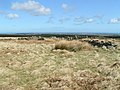
 Cup and ring marked rock on Wandylaw Moor.jpg 1,280 × 960; 319 KB
-

-
 Derelict Pier, Heylor, Shetland - geograph.org.uk - 152554.jpg 640 × 480; 78 KB
-
-
 Doune Castle - geograph.org.uk - 245270.jpg 480 × 640; 95 KB
-
 Duff House - geograph.org.uk - 254119.jpg 640 × 480; 159 KB
-
 Durham Castle - panoramio - PJMarriott (1).jpg 2,048 × 1,536; 806 KB
-
 Durham Castle - panoramio - PJMarriott (2).jpg 2,048 × 1,536; 776 KB
-
 Durham Castle - panoramio - PJMarriott (cropped 2).jpg 1,660 × 1,660; 515 KB
-
 Durham Castle - panoramio - PJMarriott (cropped).jpg 2,560 × 1,571; 720 KB
-
 Durham Castle - panoramio - PJMarriott.jpg 2,560 × 1,920; 1.41 MB
-
 Durham Cathedral - panoramio - PJMarriott (1).jpg 2,048 × 1,536; 795 KB
-
 Durham Cathedral - panoramio - PJMarriott (2) (cropped).jpg 2,560 × 1,536; 655 KB
-
 Durham Cathedral - panoramio - PJMarriott (2).jpg 2,560 × 1,920; 1.3 MB
-
 Durham Cathedral - panoramio - PJMarriott.jpg 2,048 × 1,536; 594 KB
-
 Durham Cathedral - panoramio.jpg 1,536 × 2,048; 627 KB
-
 East Hogaland, Shetland - geograph.org.uk - 152354.jpg 640 × 480; 101 KB
-
 Edge of the quarry workings - geograph.org.uk - 151509.jpg 640 × 480; 110 KB
-

-
 Estate Grounds - geograph.org.uk - 151847.jpg 640 × 480; 70 KB
-
 Farm Buildings above Llanfairfechan - geograph.org.uk - 151504.jpg 640 × 480; 124 KB
-
 Field - geograph.org.uk - 153995.jpg 640 × 480; 83 KB
-
 Field near Chudleigh Knighton - geograph.org.uk - 151516.jpg 640 × 480; 95 KB
-
 Field near Coed Bronydd Isaf - geograph.org.uk - 151471.jpg 640 × 480; 138 KB
-
 Finlake Holiday Park - geograph.org.uk - 151514.jpg 640 × 480; 96 KB
-
 Flass Tarn - geograph.org.uk - 1057585.jpg 640 × 420; 58 KB
-
 Flass Tarn - geograph.org.uk - 1057588.jpg 640 × 423; 62 KB
-
 Fludda - geograph.org.uk - 151518.jpg 640 × 480; 85 KB
-
 Flytip on the Old Shaston Drove - geograph.org.uk - 310841.jpg 640 × 408; 163 KB
-

-
 Fossilised Tree - panoramio.jpg 2,048 × 1,536; 942 KB
-

-

-
 George Street, Aberdeen (nr. Mounthooly) - geograph.org.uk - 156163.jpg 640 × 480; 117 KB
-
 Graiglwyd Fishing lake and caravan park - geograph.org.uk - 151505.jpg 640 × 480; 183 KB
-
 Great Gable at the head of Wasdale - geograph.org.uk - 1057626.jpg 640 × 424; 32 KB
-
 Helga water, near Hillswick, Shetland - geograph.org.uk - 152617.jpg 640 × 480; 80 KB
-
 Hillside near Rhiwiau Isaf - geograph.org.uk - 151501.jpg 640 × 480; 150 KB
-
 St Catherine, Hoarwithy - geograph.org.uk - 662728.jpg 640 × 480; 78 KB
-
 Hockworthy, Redgate Lane - geograph.org.uk - 151353.jpg 640 × 427; 103 KB
-
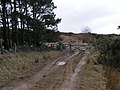
 In the Miterdale Forest - geograph.org.uk - 1057602.jpg 431 × 640; 80 KB
-
 Inverness to Aberdeen train by Richard Slessor.jpg 640 × 480; 175 KB
-
 Junction - geograph.org.uk - 151376.jpg 640 × 480; 388 KB
-
 King's Caple Court - geograph.org.uk - 662883.jpg 640 × 480; 119 KB
-
 Kings Gardens , Stanley Road, Bootle - geograph.org.uk - 157500.jpg 640 × 480; 58 KB
-
 Kinloch Rannoch.jpg 640 × 480; 123 KB
-
 Kirkby Malzeard - geograph.org.uk - 153991.jpg 640 × 480; 89 KB
-
 Lady Manners School.jpg 640 × 480; 104 KB
-
 Lamb scratching itself against a tree - geograph.org.uk - 151491.jpg 480 × 640; 185 KB
-
 Lane near Chudleigh Knighton - geograph.org.uk - 151515.jpg 640 × 480; 85 KB
-
 Lawn of Blue - geograph.org.uk - 154300.jpg 640 × 480; 184 KB
-
 Laxo burn - geograph.org.uk - 630625.jpg 640 × 434; 93 KB
-
 Lindsaylands - geograph.org.uk - 151828.jpg 640 × 480; 125 KB
-
 Little Chef and Travelodge Six Hills - geograph.org.uk - 151329.jpg 640 × 406; 95 KB
-
 Loch of Clousta, Shetland - geograph.org.uk - 152240.jpg 640 × 480; 64 KB
-
 Loch of Queyfirth, Shetland - geograph.org.uk - 152537.jpg 640 × 480; 82 KB
-
 Loch of Urafirth, Shetland - geograph.org.uk - 152566.jpg 640 × 480; 67 KB
-
 Loch shore at Ardtalnaig - geograph.org.uk - 155747.jpg 640 × 480; 119 KB
-
 Loggia, St Catherine, Hoarwithy - geograph.org.uk - 662915.jpg 640 × 458; 63 KB
-
 Looking Towards Cornhill House - geograph.org.uk - 151996.jpg 640 × 480; 80 KB
-
 Looking towards Upper Nidderdale - geograph.org.uk - 151420.jpg 640 × 480; 103 KB
-
 Main Street, Barkston Ash - geograph.org.uk - 151425.jpg 640 × 301; 192 KB
-
 Manderston House - geograph.org.uk - 151469.jpg 640 × 480; 120 KB
-
 Manderston House Stables, near Duns - geograph.org.uk - 151473.jpg 640 × 480; 99 KB
-
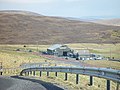
 Mavis Grind, Shetland - geograph.org.uk - 152343.jpg 640 × 480; 64 KB
-
 Mavis Grind, Shetland - geograph.org.uk - 152347.jpg 640 × 480; 50 KB
-
 Miabhaig, West Lewis - geograph.org.uk - 153634.jpg 640 × 480; 69 KB
-
 Monument De La Bastie, Near Duns - geograph.org.uk - 151465.jpg 403 × 640; 56 KB
-
 Moulton Church - geograph.org.uk - 450873.jpg 640 × 480; 77 KB
-
 Mussel Rafts, Olna Firth, Shetland - geograph.org.uk - 152340.jpg 640 × 480; 89 KB
-
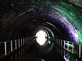 Newbold Tunnel - geograph.org.uk - 709826.jpg 640 × 480; 77 KB
-
 Newstead - geograph.org.uk - 153388.jpg 640 × 480; 140 KB
-
 Newton Farm near Garmouth - geograph.org.uk - 153805.jpg 640 × 480; 81 KB
-
 Nicolson's Garage, Bixter - geograph.org.uk - 151520.jpg 640 × 480; 99 KB
-
 North Loch of Hostigates, Shetland - geograph.org.uk - 151526.jpg 640 × 480; 64 KB
-
 Northern monorail station at Beaulieu - geograph.org.uk - 151427.jpg 640 × 480; 144 KB
-
 Ollaberry Shop, Shetland - geograph.org.uk - 152358.jpg 640 × 480; 76 KB
-
 Oriental shopping centre Aberdeen by Richard Slessor.jpg 640 × 480; 107 KB
-
 Ornamental Gardens and Dovecote - geograph.org.uk - 154302.jpg 622 × 640; 245 KB
-
 Overlooking Chelmarsh Reservoir - geograph.org.uk - 221267.jpg 640 × 480; 106 KB
-
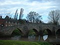 Packhorse bridge at Moulton - geograph.org.uk - 450857.jpg 640 × 480; 90 KB
-
 Pier at Gon Firth, Shetland - geograph.org.uk - 152272.jpg 640 × 480; 86 KB
-
 Preston Tower (New).jpg 1,280 × 960; 324 KB
-
 Priestsdean Burn - geograph.org.uk - 153454.jpg 640 × 480; 194 KB
-
 Railway Junction, Church Fenton - geograph.org.uk - 151862.jpg 640 × 417; 219 KB
-
 Rainbow over houses. - geograph.org.uk - 303013.jpg 640 × 480; 76 KB
-
-
 Richmond Town Centre - geograph.org.uk - 224186.jpg 640 × 480; 72 KB
-

-
 RNLI Aith Lifeboat Station, Shetland - geograph.org.uk - 152254.jpg 640 × 480; 58 KB
-
 Road across the Bovey Basin - geograph.org.uk - 151527.jpg 640 × 480; 106 KB
-
 Roadside Cottage, near Hillhampton - geograph.org.uk - 151379.jpg 640 × 479; 77 KB
-
 Ronas Voe, Shetland - geograph.org.uk - 152546.jpg 640 × 480; 56 KB
-
 Ronas Voe, Shetland - geograph.org.uk - 152551.jpg 640 × 480; 56 KB
-
 RosemountViaduct-156151-Richard Slessor.jpg 640 × 480; 122 KB
-
 Ruined Barn near Magpie Mine - geograph.org.uk - 151223.jpg 640 × 480; 71 KB
-
 Sainsbury's, Colton Retail Park - geograph.org.uk - 151849.jpg 640 × 381; 196 KB
-

-
 Sheep at Askill - geograph.org.uk - 238397.jpg 640 × 426; 121 KB
-
 Sheep grazing at Madryn - geograph.org.uk - 151498.jpg 640 × 480; 146 KB
-
 Sheep in a field - geograph.org.uk - 151484.jpg 640 × 480; 164 KB
-
 Sheep pens, Whinny Plantation - geograph.org.uk - 152900.jpg 640 × 480; 153 KB
-
 Sheepfold near Snowdon's Fold - geograph.org.uk - 152865.jpg 640 × 480; 164 KB
-
 Sherlock gets alarm fitted (128078076).jpg 800 × 535; 164 KB
-
 Slate Ford - geograph.org.uk - 152878.jpg 640 × 480; 145 KB
-
 Small hill above Llanfairfechan - geograph.org.uk - 151508.jpg 640 × 480; 112 KB
-
 Speymouth Parish Church - geograph.org.uk - 153809.jpg 640 × 480; 138 KB
-
 St Catherine, Hoarwithy - geograph.org.uk - 662719.jpg 502 × 640; 80 KB
-
 St Cuthbert's Church, Redmarshall.jpg 640 × 384; 76 KB
-
 St John Baptist, King's Caple - geograph.org.uk - 662870.jpg 640 × 480; 95 KB
-
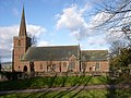
 St Maurice's Church, Ellingham - geograph.org.uk - 152830.jpg 480 × 640; 204 KB
-
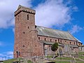 St Vigeans Parish Church.jpg 640 × 480; 89 KB
-

-

-
 Stepping Stones - Stanhope - panoramio - PJMarriott.jpg 2,048 × 1,536; 754 KB
-
 Stepping Stones - Stanhope - panoramio.jpg 2,560 × 1,920; 1.35 MB
-
 Swanscombe Allotments - geograph.org.uk - 151452.jpg 640 × 426; 77 KB
-

-
 Tees Valley - panoramio - PJMarriott.jpg 2,048 × 1,536; 536 KB
-
 Tees Valley - panoramio.jpg 2,048 × 1,536; 587 KB
-
 Templar Way in the Great Plantation - geograph.org.uk - 151510.jpg 480 × 640; 126 KB
-

-

-
 The monorail, Beaulieu - geograph.org.uk - 151462.jpg 640 × 480; 133 KB
-

-
 The Pheasant Inn, Harmby - geograph.org.uk - 151218.jpg 640 × 480; 69 KB
-

-
 The River Devon at Vicar's Bridge - geograph.org.uk - 152663.jpg 640 × 427; 166 KB
-

-

-
-
 The Screes, Wastwater - geograph.org.uk - 1057603.jpg 419 × 640; 79 KB
-
 The Swale at Brompton-on-Swale - geograph.org.uk - 162956.jpg 640 × 434; 163 KB
-
 The Victorian flower garden, Beaulieu - geograph.org.uk - 151442.jpg 640 × 480; 171 KB
-
 Thornton-le-Street Stud Western gate - geograph.org.uk - 156487.jpg 640 × 480; 85 KB
-
 Track on Foel Lus - geograph.org.uk - 151506.jpg 480 × 640; 116 KB
-
 Tree alongside country lane at Crymlyn - geograph.org.uk - 151477.jpg 480 × 640; 175 KB
-
 Twatt, Shetland - geograph.org.uk - 151522.jpg 640 × 480; 74 KB
-
 Uig Sands, Lewis - geograph.org.uk - 152969.jpg 640 × 467; 29 KB
-
 Undercut Riverbank at Brompton-on-Swale. - geograph.org.uk - 168766.jpg 640 × 434; 203 KB
-

-
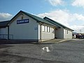
 Urafirth Primary School, Shetland - geograph.org.uk - 152568.jpg 640 × 480; 57 KB
-
 View along beach at Kilnaughton Bay - geograph.org.uk - 576054.jpg 640 × 480; 30 KB
-
 View from Ardtalnaig - geograph.org.uk - 155753.jpg 640 × 480; 136 KB
-
 View from Bottor Rock - geograph.org.uk - 151521.jpg 480 × 640; 145 KB
-
 View near Crownley - geograph.org.uk - 151512.jpg 640 × 480; 105 KB
-

-
 Voe Marina, Shetland - geograph.org.uk - 152333.jpg 640 × 480; 70 KB
-
 Waren Burn, Warenford - geograph.org.uk - 153383.jpg 640 × 480; 221 KB


_near_Cragabus_-_geograph.org.uk_-_306978.jpg)


.jpg)
.jpg)
.jpg)
.jpg)

.jpg)
_(cropped).jpg)
.jpg)


_-_geograph.org.uk_-_156160.jpg)
_-_geograph.org.uk_-_156163.jpg)


.jpg)


.jpg)


_at_Winding_Stondard_-_geograph.org.uk_-_269554.jpg)


