Category:Rail transport maps of Occitanie
Jump to navigation
Jump to search
Administrative regions and territorial collectivity of Metropolitan France (‡ since start of 2016):
Auvergne-Rhône-Alpes‡ · Bourgogne-Franche-Comté‡ · Brittany · Centre-Val de Loire · Corsica · Grand Est‡ · Hauts-de-France‡ · Île-de-France · Normandy‡ · Nouvelle-Aquitaine‡ · Occitania‡ · Pays de la Loire · Provence-Alpes-Côte d'Azur
Overseas departments and regions: Réunion
Auvergne-Rhône-Alpes‡ · Bourgogne-Franche-Comté‡ · Brittany · Centre-Val de Loire · Corsica · Grand Est‡ · Hauts-de-France‡ · Île-de-France · Normandy‡ · Nouvelle-Aquitaine‡ · Occitania‡ · Pays de la Loire · Provence-Alpes-Côte d'Azur
Overseas departments and regions: Réunion
Subcategories
This category has the following 8 subcategories, out of 8 total.
- Rail transport maps of Aude (4 F)
- Rail transport maps of Gard (9 F)
- Rail transport maps of Tarn (4 F)
R
Media in category "Rail transport maps of Occitanie"
The following 80 files are in this category, out of 80 total.
-
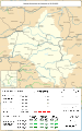
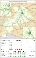
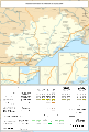
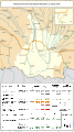
 Rail transport infrastructure map - FR - Occitanie.svg 812 × 793; 5.29 MB
-
 Railway map of France - 09 - 1900 - fr - small.svg 564 × 914; 4.21 MB
-
 Railway map of France - 09 - 1930 - fr - small.svg 564 × 914; 4.32 MB
-
 Railway map of France - 09 - 1980 - fr - small.svg 564 × 914; 4.28 MB
-
 Railway map of France - 09 - 2020 - fr - small.svg 564 × 914; 4.08 MB
-
 Railway map of France - 09 - animated - fr.gif 1,252 × 2,030; 4.03 MB
-
 Railway map of France - 11 - 1900 - fr - small.svg 705 × 914; 5.04 MB
-
 Railway map of France - 11 - 1930 - fr - small.svg 705 × 914; 5.22 MB
-
 Railway map of France - 11 - 1980 - fr - small.svg 705 × 914; 5.16 MB
-
 Railway map of France - 11 - 2020 - fr - small.svg 705 × 914; 4.95 MB
-
 Railway map of France - 11 - animated - fr.gif 1,566 × 2,030; 5 MB
-
 Railway map of France - 12 - 1900 - fr - small.svg 705 × 1,126; 6.11 MB
-
 Railway map of France - 12 - 1913 - fr - small.svg 705 × 1,126; 6.3 MB
-
 Railway map of France - 12 - 1932 - fr - small.svg 705 × 1,126; 6.28 MB
-
 Railway map of France - 12 - 1980 - fr - small.svg 705 × 1,126; 6.24 MB
-
 Railway map of France - 12 - 2020 - fr - small.svg 705 × 1,126; 6.03 MB
-
 Railway map of France - 12 - animated - fr.gif 1,566 × 2,502; 5.74 MB
-
 Railway map of France - 30 - 1850 - fr - small.svg 705 × 1,020; 5.02 MB
-
 Railway map of France - 30 - 1880 - fr - small.svg 705 × 1,020; 5.12 MB
-
 Railway map of France - 30 - 1900 - fr - small.svg 705 × 1,020; 5.22 MB
-
 Railway map of France - 30 - 1930 - fr - small.svg 705 × 1,020; 5.31 MB
-
 Railway map of France - 30 - 1950 - fr - small.svg 705 × 1,020; 5.29 MB
-
 Railway map of France - 30 - 1980 - fr - small.svg 705 × 1,020; 5.27 MB
-
 Railway map of France - 30 - 2001 - fr - small.svg 705 × 1,020; 5.28 MB
-
 Railway map of France - 30 - 2020 - fr - small.svg 705 × 1,020; 5.1 MB
-
 Railway map of France - 30 - animated - fr.gif 1,566 × 2,266; 6.01 MB
-
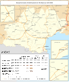
 Railway map of France - 31 - 1870 - fr - small.svg 705 × 1,126; 6.32 MB
-
 Railway map of France - 31 - 1890 - fr - small.svg 705 × 1,126; 6.36 MB
-
 Railway map of France - 31 - 1900 - fr - small.svg 705 × 1,126; 6.38 MB
-
 Railway map of France - 31 - 1914 - fr - small.svg 705 × 1,126; 6.6 MB
-
 Railway map of France - 31 - 1930 - fr - small.svg 705 × 1,126; 6.66 MB
-
 Railway map of France - 31 - 1939 - fr - small.svg 705 × 1,126; 6.59 MB
-
 Railway map of France - 31 - 1960 - fr - small.svg 705 × 1,126; 6.57 MB
-
 Railway map of France - 31 - 1980 - fr - small.svg 705 × 1,126; 6.57 MB
-
 Railway map of France - 31 - 2000 - fr - small.svg 705 × 1,126; 6.6 MB
-
 Railway map of France - 31 - 2020 - fr - small.svg 705 × 1,126; 6.47 MB
-
 Railway map of France - 31 - animated - fr.gif 1,566 × 2,502; 6.68 MB
-
 Railway map of France - 32 - 1900 - fr - small.svg 705 × 950; 5.95 MB
-
 Railway map of France - 32 - 1930 - fr - small.svg 705 × 950; 6.1 MB
-
 Railway map of France - 32 - 1980 - fr - small.svg 705 × 950; 6.04 MB
-
 Railway map of France - 32 - 2020 - fr - small.svg 705 × 950; 5.84 MB
-
 Railway map of France - 32 - animated - fr.gif 1,566 × 2,111; 5.44 MB
-
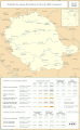
 Railway map of France - 34 - 1860 - fr - small.svg 705 × 1,041; 5.1 MB
-
 Railway map of France - 34 - 1880 - fr - small.svg 705 × 1,041; 5.19 MB
-
 Railway map of France - 34 - 1900 - fr - small.svg 705 × 1,041; 5.26 MB
-
 Railway map of France - 34 - 1913 - fr - small.svg 705 × 1,041; 5.4 MB
-
 Railway map of France - 34 - 1930 - fr - small.svg 705 × 1,041; 5.4 MB
-
 Railway map of France - 34 - 1939 - fr - small.svg 705 × 1,041; 5.36 MB
-
 Railway map of France - 34 - 1950 - fr - small.svg 705 × 1,041; 5.34 MB
-
 Railway map of France - 34 - 1980 - fr - small.svg 705 × 1,041; 5.34 MB
-
 Railway map of France - 34 - 2020 - fr - small.svg 705 × 1,041; 5.2 MB
-
 Railway map of France - 34 - animated - fr.gif 1,566 × 2,313; 6.27 MB
-
 Railway map of France - 46 - 1880 - fr - small.svg 564 × 985; 4.87 MB
-
 Railway map of France - 46 - 1900 - fr - small.svg 564 × 985; 4.93 MB
-
 Railway map of France - 46 - 1930 - fr - small.svg 564 × 985; 5.17 MB
-
 Railway map of France - 46 - 1950 - fr - small.svg 564 × 985; 5.08 MB
-
 Railway map of France - 46 - 1980 - fr - small.svg 564 × 985; 5.07 MB
-
 Railway map of France - 46 - 2020 - fr - small.svg 564 × 985; 4.89 MB
-
 Railway map of France - 46 - animated - fr.gif 1,252 × 2,188; 4.46 MB
-
 Railway map of France - 65 - 1900 - fr - small.svg 564 × 1,003; 5.03 MB
-
 Railway map of France - 65 - 1920 - fr - small.svg 564 × 1,003; 5.11 MB
-
 Railway map of France - 65 - 1939 - fr - small.svg 564 × 1,003; 5.08 MB
-
 Railway map of France - 65 - 1980 - fr - small.svg 564 × 1,003; 5.08 MB
-
 Railway map of France - 65 - 2020 - fr - small.svg 564 × 1,003; 4.88 MB
-
 Railway map of France - 65 - animated - fr.gif 1,252 × 2,227; 4.8 MB
-
 Railway map of France - 66 - 1900 - fr - small.svg 705 × 773; 3.93 MB
-
 Railway map of France - 66 - 1930 - fr - small.svg 705 × 773; 4 MB
-
 Railway map of France - 66 - 1950 - fr - small.svg 705 × 773; 3.98 MB
-
 Railway map of France - 66 - 1980 - fr - small.svg 705 × 773; 3.98 MB
-
 Railway map of France - 66 - 2020 - fr - small.svg 705 × 773; 3.78 MB
-
 Railway map of France - 66 - animated - fr.gif 1,566 × 1,716; 3.76 MB
-
 Railway map of France - 81 - 1900 - fr - small.svg 564 × 914; 4.78 MB
-
 Railway map of France - 81 - 1930 - fr - small.svg 564 × 914; 5 MB
-
 Railway map of France - 81 - 1980 - fr - small.svg 564 × 914; 4.91 MB
-
 Railway map of France - 81 - 2020 - fr - small.svg 564 × 914; 4.71 MB
-
 Railway map of France - 81 - animated - fr.gif 1,252 × 2,030; 4.56 MB
-
 Railway map of France - Montpellier - animated - fr.gif 1,691 × 1,723; 14.25 MB
-
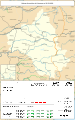
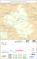
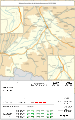
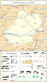
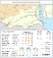
 Railway map of France - OCC - 1930 - fr - small.svg 783 × 921; 8.91 MB
-
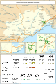
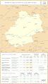
 Railway map of France - OCC - 2020 - fr - small.svg 783 × 921; 8.93 MB
-
 Railway map of France - Toulouse - animated - fr.gif 2,150 × 1,561; 18.85 MB


