Category:Rail transport maps of Nouvelle-Aquitaine
Jump to navigation
Jump to search
Administrative regions and territorial collectivity of Metropolitan France (‡ since start of 2016):
Auvergne-Rhône-Alpes‡ · Bourgogne-Franche-Comté‡ · Brittany · Centre-Val de Loire · Corsica · Grand Est‡ · Hauts-de-France‡ · Île-de-France · Normandy‡ · Nouvelle-Aquitaine‡ · Occitania‡ · Pays de la Loire · Provence-Alpes-Côte d'Azur
Overseas departments and regions: Réunion
Auvergne-Rhône-Alpes‡ · Bourgogne-Franche-Comté‡ · Brittany · Centre-Val de Loire · Corsica · Grand Est‡ · Hauts-de-France‡ · Île-de-France · Normandy‡ · Nouvelle-Aquitaine‡ · Occitania‡ · Pays de la Loire · Provence-Alpes-Côte d'Azur
Overseas departments and regions: Réunion
Subcategories
This category has the following 9 subcategories, out of 9 total.
C
R
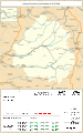
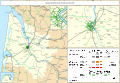
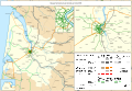
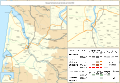
Media in category "Rail transport maps of Nouvelle-Aquitaine"
The following 50 files are in this category, out of 50 total.
-
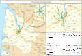
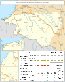
 LGV Bordeaux Espagne (cadré openstreetmap).png 1,067 × 1,735; 2.32 MB
-
 Rail transport infrastructure map - FR - Nouvelle-Aquitaine.svg 832 × 983; 7.39 MB
-
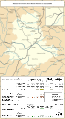
 Railway map of France - 19 - 1880 - fr - small.svg 705 × 950; 5.24 MB
-
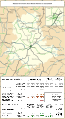
 Railway map of France - 19 - 1900 - fr - small.svg 705 × 950; 5.32 MB
-
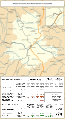
 Railway map of France - 19 - 1930 - fr - small.svg 705 × 950; 5.49 MB
-
 Railway map of France - 19 - 1950 - fr - small.svg 705 × 950; 5.44 MB
-
 Railway map of France - 19 - 1980 - fr - small.svg 705 × 950; 5.42 MB
-
 Railway map of France - 19 - 2020 - fr - small.svg 705 × 950; 5.22 MB
-
 Railway map of France - 19 - animated - fr.gif 1,566 × 2,111; 4.93 MB
-
 Railway map of France - 24 - 1870 - fr - small.svg 705 × 1,126; 5.98 MB
-
 Railway map of France - 24 - 1900 - fr - small.svg 705 × 1,126; 6.17 MB
-
 Railway map of France - 24 - 1929 - fr - small.svg 705 × 1,126; 6.46 MB
-
 Railway map of France - 24 - 1980 - fr - small.svg 705 × 1,126; 6.31 MB
-
 Railway map of France - 24 - 2020 - fr - small.svg 705 × 1,126; 6.11 MB
-
 Railway map of France - 24 - animated - fr.gif 1,566 × 2,502; 5.76 MB
-
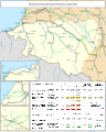
 Railway map of France - 33 - 1860 - fr - small.svg 1,273 × 879; 6.69 MB
-
 Railway map of France - 33 - 1885 - fr - small.svg 1,273 × 879; 6.87 MB
-
 Railway map of France - 33 - 1900 - fr - small.svg 1,273 × 879; 7.11 MB
-
 Railway map of France - 33 - 1913 - fr - small.svg 1,273 × 879; 7.44 MB
-
 Railway map of France - 33 - 1929 - fr - small.svg 1,273 × 879; 7.51 MB
-
 Railway map of France - 33 - 1939 - fr - small.svg 1,273 × 879; 7.41 MB
-
 Railway map of France - 33 - 1960 - fr - small.svg 1,273 × 879; 7.35 MB
-
 Railway map of France - 33 - 1980 - fr - small.svg 1,273 × 879; 7.34 MB
-
 Railway map of France - 33 - 2000 - fr - small.svg 1,273 × 879; 7.34 MB
-
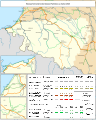
 Railway map of France - 33 - 2020 - fr - small.svg 1,273 × 879; 7.21 MB
-
 Railway map of France - 33 - animated - fr.gif 2,672 × 1,845; 8.97 MB
-
 Railway map of France - 40 - 1900 - fr - small.svg 705 × 1,056; 5.4 MB
-
 Railway map of France - 40 - 1930 - fr - small.svg 705 × 1,056; 5.54 MB
-
 Railway map of France - 40 - 1980 - fr - small.svg 705 × 1,056; 5.5 MB
-
 Railway map of France - 40 - 2020 - fr - small.svg 705 × 1,056; 5.29 MB
-
 Railway map of France - 64 - 1880 - fr - small.svg 776 × 968; 5.56 MB
-
 Railway map of France - 64 - 1900 - fr - small.svg 776 × 968; 5.61 MB
-
 Railway map of France - 64 - 1913 - fr - small.svg 776 × 968; 5.7 MB
-
 Railway map of France - 64 - 1928 - fr - small.svg 776 × 968; 5.78 MB
-
 Railway map of France - 64 - 1950 - fr - small.svg 776 × 968; 5.71 MB
-
 Railway map of France - 64 - 1980 - fr - small.svg 776 × 968; 5.71 MB
-
 Railway map of France - 64 - 2020 - fr - small.svg 776 × 968; 5.51 MB
-
 Railway map of France - 64 - animated - fr.gif 1,725 × 2,150; 5.95 MB
-
 Railway map of France - 79 - animated - fr.gif 1,246 × 2,374; 5.44 MB
-
 Railway map of France - 87 - 1885 - fr - small.svg 564 × 1,031; 4.82 MB
-
 Railway map of France - 87 - 1900 - fr - small.svg 564 × 1,031; 4.92 MB
-
 Railway map of France - 87 - 1930 - fr - small.svg 564 × 1,031; 5.17 MB
-
 Railway map of France - 87 - 1950 - fr - small.svg 564 × 1,031; 5.06 MB
-
 Railway map of France - 87 - 1980 - fr - small.svg 564 × 1,031; 5.04 MB
-
 Railway map of France - 87 - 2020 - fr - small.svg 564 × 1,031; 4.85 MB
-
 Railway map of France - 87 - animated - fr.gif 1,252 × 2,291; 4.97 MB
-
 Railway map of France - Bordeaux - animated - fr.gif 2,067 × 1,501; 20.21 MB
-
 Railway map of France - Limoges - animated - fr.gif 1,566 × 1,811; 5.05 MB
-
 Railway map of France - NAQ - 1930 - fr - small.svg 783 × 1,346; 11.57 MB
-
 Railway map of France - NAQ - 2020 - fr - small.svg 783 × 1,346; 11.48 MB
.png)


