
Category:May 2009 in Suffolk
Ceremonial counties of England: Bedfordshire · Berkshire · Buckinghamshire · Cambridgeshire · Cheshire · Cornwall · Cumbria · Derbyshire · Devon · Dorset · Durham · East Riding of Yorkshire · East Sussex · Essex · Gloucestershire · Greater London · Greater Manchester · Hampshire · Herefordshire · Hertfordshire · Isle of Wight · Kent · Lancashire · Leicestershire · Lincolnshire · Merseyside · Norfolk · North Yorkshire · Northamptonshire · Northumberland · Nottinghamshire · Oxfordshire · Shropshire · Somerset · South Yorkshire · Staffordshire · Suffolk · Surrey · Tyne and Wear · Warwickshire · West Midlands · West Sussex · West Yorkshire · Wiltshire · Worcestershire
City-counties: Bristol ·
Former historic counties:
Other former counties:
City-counties: Bristol ·
Former historic counties:
Other former counties:
Deutsch: Bilder, die im Mai 2009 in Suffolk aufgenommen worden sind. Bitte beachten Sie, dass dies weder das Datum des Uploads noch das Datum des Scannens eines Fotos ist.
English: Images/pictures taken in Suffolk during May 2009. Note this is not the date of the upload, nor the date a photo was scanned.
Español: Fotografías o imágenes tomadas en Suffolk durante mayo 2009. No es la fecha de subida ni escaneo, sino la fecha en que las fotografías o imágenes se crearon.
Esperanto: Bildoj faritaj en Suffolk en majo 2009. Tio ne estas la dato, kiam la bildoj estis alŝutitaj aŭ skanitaj.
Français : Photographies ou images prises en Suffolk durant mai 2009. Ce n'est pas la date du téléchargement ou du scan.
Galego: Fotografías ou imaxes tomadas en Suffolk durante maio 2009. Non é a data de subida nin escaneamento, senón a data na que se crearon as fotografías ou imaxes.
Italiano: Fotografie o immagini scattate a Suffolk nel maggio 2009. Nota bene: la data non si riferisce né a quella di upload né a quella in cui la foto è stata digitalizzata.
Norsk bokmål: Bilder tatt i Suffolk i løpet av mai 2009. Merk at dette ikke er datoen for opplasting, eller når et bilde har blitt skannet.
Norsk nynorsk: Bilete teke i Suffolk i løpet av mai 2009. Merk at dette ikkje er datoen for opplasting, eller når eit bilete har vorte skanna.
Русский: Изображения, сделанные в Suffolk в течение май 2009 (не дата загрузки изображения).
Українська: Зображення, зроблені в Suffolk протягом травень 2009. Зауважте, що це не дата завантаження чи дата сканування фотографії.
中文: 5月 2009在Suffolk拍攝的圖像/照片。 請注意,這不是上傳日期,也不是掃描照片的日期。
| May 2008 | ← | May 2009 | → | May 2010 | |||||||
| Jan | Feb | Mar | Apr | May | Jun | Jul | Aug | Sep | Oct | Nov | Dec |
| 180 | 160 | 129 | 184 | 214 | 110 | 173 | 235 | 150 | 47 | 95 | 72 |
|---|---|---|---|---|---|---|---|---|---|---|---|
Subcategories
This category has the following 2 subcategories, out of 2 total.
R
- RAF Mildenhall Air Fete 2009 (22 F)
Media in category "May 2009 in Suffolk"
The following 200 files are in this category, out of 212 total.
(previous page) (next page)-
 Church Cottages, Lavenham - geograph.org.uk - 1323775.jpg 640 × 425; 65 KB
-
 70013 pulling into Ipswich station - geograph.org.uk - 1320871.jpg 640 × 480; 78 KB
-
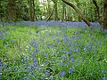 A carpet of bluebells - geograph.org.uk - 1294527.jpg 640 × 480; 153 KB
-
 A Corner Of Fencing - geograph.org.uk - 1296928.jpg 640 × 480; 89 KB
-
 A Suffolk field - geograph.org.uk - 1296167.jpg 640 × 480; 50 KB
-
 A Suffolk field - geograph.org.uk - 1309473.jpg 640 × 463; 118 KB
-
 A Suffolk field - geograph.org.uk - 1312388.jpg 640 × 480; 77 KB
-
 A Suffolk field - geograph.org.uk - 1316720.jpg 640 × 480; 78 KB
-
 A Suffolk field - geograph.org.uk - 1316733.jpg 640 × 480; 67 KB
-
 A Suffolk field - geograph.org.uk - 1316739.jpg 640 × 480; 68 KB
-
 Adnam's Brewery - geograph.org.uk - 1422183.jpg 640 × 426; 70 KB
-
 Alderman Road - geograph.org.uk - 1305086.jpg 640 × 428; 71 KB
-
 Alderman Road recreation ground - geograph.org.uk - 1305059.jpg 640 × 428; 71 KB
-
 Alexandra Park - geograph.org.uk - 1306016.jpg 480 × 640; 112 KB
-
 Alexandra Park - geograph.org.uk - 1306035.jpg 640 × 480; 77 KB
-
 All Saints church, Chevallier Street - geograph.org.uk - 1315007.jpg 640 × 433; 84 KB
-
 Allis-Chalmers ED-40.jpg 2,144 × 1,424; 1.71 MB
-
 Almshouses, Cliff Lane - geograph.org.uk - 1309538.jpg 640 × 480; 123 KB
-
 Alton Business Centre - geograph.org.uk - 1294509.jpg 640 × 480; 87 KB
-
 Anthocharis cardamines - geograph.org.uk - 1310517.jpg 640 × 604; 197 KB
-
 Approaching Lowestoft - geograph.org.uk - 1317642.jpg 640 × 480; 52 KB
-
 St Mary's church Bentley Suffolk (4157991716).jpg 1,600 × 1,067; 325 KB
-
 Book day in Westleton - geograph.org.uk - 1363213.jpg 640 × 480; 82 KB
-
 Boyton Marshes - geograph.org.uk - 1298304.jpg 640 × 480; 50 KB
-
 Boyton Village Sign - geograph.org.uk - 1298148.jpg 480 × 640; 155 KB
-
 St Andrew's church Bramfield Suffolk (5565075503).jpg 1,600 × 1,067; 195 KB
-
 St Andrew's church Bramfield Suffolk (5565653062).jpg 1,600 × 1,072; 234 KB
-
-
 Butley Ferry - geograph.org.uk - 1303087.jpg 640 × 480; 55 KB
-
 Butley Ferry Jetty - geograph.org.uk - 1308635.jpg 640 × 480; 58 KB
-
 Christ Church Felixstowe - geograph.org.uk - 1323133.jpg 640 × 480; 123 KB
-
-
 Church of the Holy Trinity - geograph.org.uk - 1305679.jpg 640 × 480; 87 KB
-
 Church tower - geograph.org.uk - 1294449.jpg 480 × 640; 126 KB
-
 Cliff Lane - geograph.org.uk - 1307805.jpg 640 × 480; 81 KB
-
 Cliff Road - geograph.org.uk - 1326237.jpg 640 × 480; 51 KB
-
 Coastal scenery by the Stour - geograph.org.uk - 1283034.jpg 640 × 435; 86 KB
-
 Colony Evacuation Sluice - geograph.org.uk - 1297333.jpg 640 × 480; 81 KB
-

-
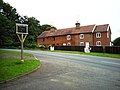 Cottages at Brightwell - geograph.org.uk - 1323148.jpg 640 × 480; 108 KB
-
 Cottages at Cavendish - geograph.org.uk - 1323028.jpg 640 × 425; 77 KB
-
 Cottages At Gulpher - geograph.org.uk - 1288041.jpg 640 × 480; 123 KB
-
 Cottages in Stuston - geograph.org.uk - 1297500.jpg 640 × 415; 112 KB
-
 Cottages near Hill Farm - geograph.org.uk - 1296174.jpg 640 × 480; 68 KB
-
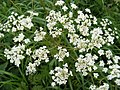 Cow Parsley in Station Road - geograph.org.uk - 1296289.jpg 3,072 × 2,304; 1.38 MB
-

-
 Curved Plough Lines - geograph.org.uk - 1303112.jpg 640 × 480; 67 KB
-
 Cutters Lane - geograph.org.uk - 1290309.jpg 640 × 480; 74 KB
-
 Cyclepath in Holywells park - geograph.org.uk - 1305639.jpg 640 × 480; 138 KB
-
 Cyclepath to Gainsborough Lane - geograph.org.uk - 1307844.jpg 640 × 480; 81 KB
-
 Dead tree - geograph.org.uk - 1312420.jpg 480 × 640; 93 KB
-
 Deben At Low Tide - geograph.org.uk - 1295187.jpg 640 × 480; 100 KB
-
 Demolition in progress - geograph.org.uk - 1321119.jpg 640 × 480; 62 KB
-
 Demolition in progress - geograph.org.uk - 1321125.jpg 640 × 480; 59 KB
-
 Dereham Avenue - geograph.org.uk - 1307794.jpg 640 × 480; 56 KB
-
 Duck Speed Limit - geograph.org.uk - 1286670.jpg 480 × 640; 150 KB
-

-
 Entering Lowestoft - geograph.org.uk - 1315593.jpg 640 × 480; 51 KB
-
 Entrance to Holywells park - geograph.org.uk - 1305610.jpg 640 × 480; 78 KB
-
 Edward VII Postbox - geograph.org.uk - 1319916.jpg 480 × 640; 132 KB
-
 St John's Church, Felixstowe - geograph.org.uk - 1321605.jpg 480 × 640; 99 KB
-
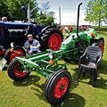
 Fendt Geräteträger, Great Whelnetham Classic Tractor and Car show 1.jpg 1,657 × 1,106; 1.27 MB
-
 Fendt Geräteträger, Great Whelnetham Classic Tractor and Car show 2.jpg 1,296 × 1,295; 1.05 MB
-
 Fendt Geräteträger, Great Whelnetham Classic Tractor and Car show 3.jpg 1,294 × 1,857; 1.38 MB
-
 Field and the first houses in Shotley - geograph.org.uk - 1282493.jpg 640 × 422; 108 KB
-
 Field and trees around Playford Hall - geograph.org.uk - 1306138.jpg 640 × 494; 136 KB
-
 Field by the Stour - geograph.org.uk - 1283057.jpg 640 × 423; 70 KB
-
 Field west of Harkstead - geograph.org.uk - 1282833.jpg 640 × 475; 69 KB
-
 Fields - geograph.org.uk - 1286700.jpg 640 × 480; 79 KB
-
 Fields and trees - geograph.org.uk - 1282714.jpg 640 × 516; 112 KB
-

-
 Fields by the Stour - geograph.org.uk - 1283070.jpg 640 × 380; 87 KB
-
 Fields towards Shotley - geograph.org.uk - 1284584.jpg 640 × 455; 93 KB
-
 Footpath across the fields - geograph.org.uk - 1281082.jpg 640 × 480; 69 KB
-
 Footpath across the fields - geograph.org.uk - 1312363.jpg 640 × 480; 76 KB
-
 Footpath and pylons - geograph.org.uk - 1294525.jpg 640 × 480; 59 KB
-
 Footpath by the Stour - geograph.org.uk - 1283099.jpg 640 × 444; 109 KB
-
 Footpath Crossings - geograph.org.uk - 1284085.jpg 640 × 480; 100 KB
-
 Footpath from Rectory Road - geograph.org.uk - 1282825.jpg 640 × 436; 108 KB
-
 Footpath in Combs Wood - geograph.org.uk - 1299854.jpg 480 × 640; 145 KB
-
 Footpath off Heveningham Long Lane - geograph.org.uk - 1316427.jpg 3,072 × 2,304; 1.62 MB
-
 Footpath to Dunwich Lane - geograph.org.uk - 1316398.jpg 2,304 × 3,072; 2.59 MB
-
 Footpath to Illketshall Hall - geograph.org.uk - 1301177.jpg 3,072 × 2,304; 1.35 MB
-
 Footpath to Manor Farm - geograph.org.uk - 1301164.jpg 2,304 × 3,072; 1.9 MB
-
 Footpath to Morland Road - geograph.org.uk - 1308047.jpg 640 × 480; 91 KB
-
 Footpath towards Thorpeness, Aldeburgh - geograph.org.uk - 1344942.jpg 640 × 480; 165 KB
-
 Footpath Where - geograph.org.uk - 1284096.jpg 480 × 640; 81 KB
-
 Former Chapel - geograph.org.uk - 1303187.jpg 640 × 480; 86 KB
-
 Friar's Lane - geograph.org.uk - 1292475.jpg 640 × 480; 113 KB
-
 Garland Street Baptist Chapel - geograph.org.uk - 1292382.jpg 640 × 455; 102 KB
-
 Gate And Stile - geograph.org.uk - 1303059.jpg 640 × 480; 65 KB
-

-
 Graffiti On Bollard - geograph.org.uk - 1301867.jpg 480 × 640; 113 KB
-
 Green Field - geograph.org.uk - 1298092.jpg 640 × 480; 81 KB
-
 Green Fields - geograph.org.uk - 1315792.jpg 640 × 480; 77 KB
-
 Green Footpath - geograph.org.uk - 1284146.jpg 640 × 480; 90 KB
-
 Greenfinch Church - geograph.org.uk - 1309409.jpg 640 × 483; 67 KB
-
 Guildhall Street - geograph.org.uk - 1292487.jpg 640 × 471; 90 KB
-
 Handford sluice - geograph.org.uk - 1305092.jpg 640 × 428; 71 KB
-
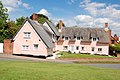
 Hexagonal Cottage - geograph.org.uk - 1288048.jpg 640 × 480; 122 KB
-
 Holywells park - geograph.org.uk - 1305622.jpg 480 × 640; 152 KB
-
 House near Harkstead Church - geograph.org.uk - 1282816.jpg 640 × 453; 104 KB
-
 House outside Hasketon - geograph.org.uk - 1280998.jpg 640 × 480; 124 KB
-
 House, Ipswich Road - geograph.org.uk - 1299541.jpg 640 × 410; 90 KB
-
 Houses along Old Barrack Road - geograph.org.uk - 1280684.jpg 640 × 480; 86 KB
-
 Houses on Cromer Road - geograph.org.uk - 1294457.jpg 640 × 480; 99 KB
-
 Houses set back from Highfield Road - geograph.org.uk - 1294472.jpg 640 × 476; 114 KB
-
 I See No People - geograph.org.uk - 1298072.jpg 480 × 640; 81 KB
-
 Illketshall St.Lawrence Village Hall sign - geograph.org.uk - 1301157.jpg 3,072 × 2,304; 1.36 MB
-
 Industry along Leslie Road - geograph.org.uk - 1308229.jpg 640 × 480; 55 KB
-
 Ipswich Crown Court - geograph.org.uk - 1305048.jpg 640 × 428; 48 KB
-
 Ipswich tunnel - geograph.org.uk - 1320889.jpg 640 × 480; 91 KB
-
 Landseer Park - geograph.org.uk - 1307812.jpg 640 × 480; 96 KB
-
 Landseer Park - geograph.org.uk - 1307818.jpg 640 × 480; 159 KB
-
 Lane towards Erwarton church and hall - geograph.org.uk - 1282647.jpg 640 × 444; 105 KB
-
 Level Crossing - geograph.org.uk - 1305590.jpg 640 × 480; 70 KB
-
 Level crossing at Thorpe Lane - geograph.org.uk - 1312423.jpg 640 × 480; 50 KB
-
 Line of tractors at Great Whelnetham Classic Car and Tractor Show.jpg 2,140 × 713; 639 KB
-
 Line of trees at Shelterhouse Corner - geograph.org.uk - 1328698.jpg 640 × 427; 100 KB
-
 Little And Large - geograph.org.uk - 1298065.jpg 640 × 480; 125 KB
-

-
 Lowestoft railway station - geograph.org.uk - 1317653.jpg 640 × 480; 68 KB
-
 Margaret Catchpole - geograph.org.uk - 1299823.jpg 640 × 480; 116 KB
-
 Marked Footpath - geograph.org.uk - 1284060.jpg 640 × 480; 109 KB
-
 Martello Tower, Shotley - geograph.org.uk - 1359405.jpg 640 × 470; 90 KB
-
 Mature Avenue - geograph.org.uk - 1324624.jpg 480 × 640; 108 KB
-
 Maude Street - geograph.org.uk - 1305701.jpg 640 × 480; 60 KB
-
 Melton station - geograph.org.uk - 1318845.jpg 640 × 480; 62 KB
-
 Mersey Road - geograph.org.uk - 1307791.jpg 640 × 480; 72 KB
-
 Miniature cliff by the Stour - geograph.org.uk - 1283031.jpg 640 × 445; 129 KB
-
 Modern houses in Thurston - geograph.org.uk - 1281213.jpg 640 × 426; 86 KB
-
 Modern town houses - geograph.org.uk - 1294425.jpg 640 × 480; 85 KB
-
 Narrow footpath - geograph.org.uk - 1292456.jpg 480 × 640; 191 KB
-

-
 New flats along Duke Street - geograph.org.uk - 1305656.jpg 640 × 480; 74 KB
-
 New flats along the Gipping - geograph.org.uk - 1305132.jpg 640 × 428; 69 KB
-
 New houses, Belstead - geograph.org.uk - 1309512.jpg 640 × 480; 82 KB
-
 Northern bank of the River Stour - geograph.org.uk - 1283061.jpg 640 × 429; 92 KB
-
 Norwich Road - geograph.org.uk - 1315009.jpg 640 × 480; 89 KB
-
 Old British railways carriage - geograph.org.uk - 1320859.jpg 640 × 480; 93 KB
-
 Old Building - geograph.org.uk - 1298233.jpg 640 × 480; 89 KB
-
 Old building in Holywells park - geograph.org.uk - 1305634.jpg 640 × 480; 62 KB
-
 Old cottages by Holywell park - geograph.org.uk - 1305617.jpg 640 × 480; 125 KB
-
 Old Pillbox - geograph.org.uk - 1298342.jpg 640 × 480; 80 KB
-
 Old Railway Bridge - geograph.org.uk - 1315822.jpg 640 × 480; 165 KB
-
 Open fields north of the Stour - geograph.org.uk - 1283080.jpg 640 × 480; 99 KB
-
 Oulton Road - geograph.org.uk - 1307802.jpg 640 × 480; 63 KB
-

-
 Path by dead tree - geograph.org.uk - 1306101.jpg 379 × 640; 93 KB
-
 Police Station - geograph.org.uk - 1309954.jpg 640 × 480; 87 KB
-
 Pond at Gifford's Hall - geograph.org.uk - 1323244.jpg 640 × 425; 125 KB
-
 Pond near Pountney Hall - geograph.org.uk - 1297555.jpg 640 × 436; 118 KB
-
 Pond near Pountney Hall - geograph.org.uk - 1297558.jpg 640 × 497; 117 KB
-
 Postbox - geograph.org.uk - 1286760.jpg 480 × 640; 148 KB
-
 Potato field by the Stour - geograph.org.uk - 1283065.jpg 640 × 394; 114 KB
-
 Railway bridge at Thurston - geograph.org.uk - 1281233.jpg 640 × 494; 121 KB
-
 Railway embankment near Thrandeston - geograph.org.uk - 1297505.jpg 640 × 403; 87 KB
-
 Railway line in a cutting - geograph.org.uk - 1305836.jpg 640 × 458; 126 KB
-
 Railway Line To Woodbridge - geograph.org.uk - 1295179.jpg 640 × 480; 112 KB
-

-
 Ramada Encore hotel, Ipswich - geograph.org.uk - 1305129.jpg 640 × 428; 61 KB
-
 Red Massey Ferguson 135 during Great Whelnetham Classic Tractor and Car show.jpg 2,144 × 1,424; 2.33 MB
-
 River Deben Swan Flotilla - geograph.org.uk - 1343427.jpg 640 × 426; 64 KB
-
 Riverside path under Yarmouth Road - geograph.org.uk - 1315002.jpg 640 × 480; 123 KB
-

-
 Russell Road, Ipswich - geograph.org.uk - 1305042.jpg 640 × 428; 112 KB
-
 Severn Road - geograph.org.uk - 1307785.jpg 640 × 480; 58 KB
-
 Sewage Works, Sandyhill Road, Ipswich - geograph.org.uk - 1299850.jpg 625 × 480; 132 KB
-
 Shop on Bramford Road - geograph.org.uk - 1294417.jpg 640 × 422; 66 KB
-
 Signs - geograph.org.uk - 1298060.jpg 640 × 480; 69 KB
-
 Simpsons Saltings - geograph.org.uk - 1298348.jpg 640 × 480; 67 KB
-
 Sir Alf Ramsey Way - geograph.org.uk - 1305096.jpg 640 × 428; 45 KB
-

-
 St. Augustine of Hippo - geograph.org.uk - 1316685.jpg 640 × 480; 107 KB
-
 St. Clement's Congregational Church - geograph.org.uk - 1305736.jpg 640 × 480; 66 KB
-
 St. Clement's Congregational Church - geograph.org.uk - 1306003.jpg 640 × 480; 73 KB
-
 St. Mary the Virgin, Belstead - geograph.org.uk - 1309505.jpg 640 × 480; 101 KB
-
 St. Mary's, Walton - geograph.org.uk - 1325942.jpg 640 × 480; 87 KB
-
 St. Mary's, Walton - geograph.org.uk - 1325960.jpg 640 × 399; 57 KB
-
 Stained glass, St Mary's Church - geograph.org.uk - 1306173.jpg 640 × 495; 131 KB
-
 Station Hotel - geograph.org.uk - 1305148.jpg 640 × 428; 79 KB
-
 Stowmarket Railway Station - geograph.org.uk - 1314669.jpg 640 × 480; 324 KB
-
 Stowmarket Railway Station - geograph.org.uk - 1314673.jpg 640 × 480; 333 KB
-
 Suffolk College Campus - geograph.org.uk - 1305718.jpg 640 × 480; 62 KB
-
 Suffolk College Campus - geograph.org.uk - 1305723.jpg 640 × 480; 83 KB
-
 Suffolk-OrfordCastle.jpg 6,000 × 4,000; 9.04 MB
-
 Sycamore in flower - geograph.org.uk - 1306206.jpg 640 × 513; 167 KB
-
 Thames barge tied up at Ipswich - geograph.org.uk - 1314984.jpg 640 × 480; 41 KB
-
 Thatched House - geograph.org.uk - 1283818.jpg 640 × 480; 109 KB
-
 The bridge over the railway line - geograph.org.uk - 1320927.jpg 640 × 480; 71 KB
-
 The Drift - geograph.org.uk - 1308238.jpg 640 × 480; 81 KB
-
 The footbridge - geograph.org.uk - 1317611.jpg 640 × 480; 56 KB
-
 The line to Ipswich - geograph.org.uk - 1294523.jpg 640 × 480; 106 KB
-
 The line to Ipswich - geograph.org.uk - 1325911.jpg 640 × 480; 82 KB
-
 The Queen's Head pub - geograph.org.uk - 1282640.jpg 640 × 459; 110 KB
-
 The Traverse - geograph.org.uk - 1292376.jpg 640 × 461; 113 KB
-
 The White Horse - geograph.org.uk - 1326224.jpg 640 × 480; 71 KB
-
 Thorpeness railway station in 2009.jpg 640 × 426; 123 KB
-
 Thurston station - geograph.org.uk - 1281652.jpg 639 × 640; 129 KB
-
 Trees At Footpath Junction - geograph.org.uk - 1290315.jpg 640 × 480; 122 KB


.jpg)


.jpg)
.jpg)


