Category:Maps showing the 1030s
Jump to navigation
Jump to search
| Maps showing the 11th century: |
Not to be confused with maps made in the 1030s.
Subcategories
This category has the following 3 subcategories, out of 3 total.
- Maps showing 1030 (15 F)
- Maps showing 1031 (2 F)
- Maps showing 1037 (17 F)
Media in category "Maps showing the 1030s"
The following 16 files are in this category, out of 16 total.
-
 Location map Taifa of Albarracín.svg 713 × 601; 281 KB
-
 Location map Taifa of Almeria Arabic.svg 713 × 601; 279 KB
-
 Location map Taifa of Almería.svg 713 × 601; 279 KB
-
 Location map Taifa of Alpuente.svg 713 × 601; 282 KB
-
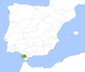 Location map Taifa of Arcos.svg 713 × 601; 282 KB
-
 Location map Taifa of Carmona.svg 713 × 601; 282 KB
-
 Location map Taifa of Huelva.svg 713 × 601; 282 KB
-
 Location map Taifa of Morón.svg 713 × 601; 279 KB
-
 Location map Taifa of Mértola.svg 713 × 601; 280 KB
-
 Location map Taifa of Niebla.svg 713 × 601; 279 KB
-
 Location map Taifa of Ronda.svg 713 × 601; 279 KB
-
 Location map Taifa of St. María del Algarve.svg 713 × 601; 292 KB
-
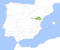
 Location map Taifa of Tortosa.svg 713 × 601; 284 KB
-
 Reinos de Taifas 1037.svg 694 × 540; 278 KB
-
 Reinos de Taifas en 1037 rus.svg 694 × 540; 886 KB
-
 Taifa of Valencia 1038-fr.svg 3,521 × 3,396; 41 KB


