Category:Maps showing 1037
Jump to navigation
Jump to search
| 1030 1031 1037 → |
English: Maps showing the year 1037 (i.e. history maps)
See also category: 1037 maps. and 1030s maps for more maps showing this year usually created not long after the given year.
See also category: 1037 maps. and 1030s maps for more maps showing this year usually created not long after the given year.
Media in category "Maps showing 1037"
The following 17 files are in this category, out of 17 total.
-
 España1037.jpg 826 × 640; 522 KB
-
 Island of the Jewel.png 2,232 × 946; 3.25 MB
-
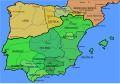
 Kingdom of Aragon-1037-ar.svg 882 × 612; 207 KB
-
 Kingdom of Aragon-1037-hu.svg 827 × 574; 257 KB
-
 Kingdom of Aragon-1037.svg 827 × 574; 255 KB
-
 Kingdom of Leon 1037 bg.svg 827 × 574; 253 KB
-
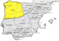 Kingdom of Leon 1037-pt.svg 827 × 574; 255 KB
-
 Kingdom of Leon 1037.svg 827 × 574; 253 KB
-
 Location map Taifa of Algeciras.svg 713 × 601; 282 KB
-
 Location map Taifa of Denia.svg 713 × 601; 279 KB
-
 Location map Taifa of Málaga.svg 713 × 601; 284 KB
-
 Map Iberian Peninsula 1037-bg.svg 827 × 574; 253 KB
-
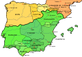 Map Iberian Peninsula 1037-en.svg 827 × 574; 252 KB
-
 Map Iberian Peninsula 1037-es.svg 827 × 574; 252 KB
-
 Map Iberian Peninsula 1037-hu.svg 827 × 574; 256 KB
-
 Map Iberian Peninsula 1037-pt.svg 512 × 355; 101 KB
-
 Spain in 1037 (William R. Shepherd).jpg 860 × 673; 300 KB


.jpg)