Category:Maps of the history of Norway
Jump to navigation
Jump to search
Countries of Europe: Albania · Andorra · Armenia‡ · Austria · Azerbaijan‡ · Belarus · Belgium · Bosnia and Herzegovina · Bulgaria · Croatia · Cyprus‡ · Czech Republic · Denmark · Estonia · Finland · France‡ · Georgia‡ · Germany · Greece · Hungary · Iceland · Republic of Ireland · Italy · Kazakhstan‡ · Latvia · Lithuania · Luxembourg · Malta · Moldova · Montenegro · Netherlands‡ · North Macedonia · Norway · Poland · Portugal‡ · Romania · Russia‡ · Serbia · Slovakia · Slovenia · Spain‡ · Sweden · Switzerland · Turkey‡ · Ukraine · United Kingdom
Limited recognition: Abkhazia‡ · Kosovo · South Ossetia‡ · Transnistria · Northern Cyprus‡
‡: partly located in Europe
Limited recognition: Abkhazia‡ · Kosovo · South Ossetia‡ · Transnistria · Northern Cyprus‡
‡: partly located in Europe
Wikimedia category | |||||
| Upload media | |||||
| Instance of | |||||
|---|---|---|---|---|---|
| |||||
Subcategories
This category has the following 5 subcategories, out of 5 total.
M
- Maps of the Kalmar Union (12 F)
- Maps of the Norwegian Empire (12 F)
Media in category "Maps of the history of Norway"
The following 115 files are in this category, out of 115 total.
-
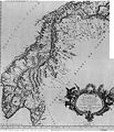 1668-Map-of-Norway.JPG 2,658 × 3,092; 3.24 MB
-
 Armfeldt Campaign in Norway 1718.svg 5,176 × 4,018; 991 KB
-
 Baltic Sea Borderlines 1939 german-it.png 2,528 × 1,965; 458 KB
-
 Battles of eirikr in baltic.png 484 × 404; 143 KB
-
 BorgarVast1.jpg 1,153 × 1,700; 236 KB
-
 Bradsberg-amt.jpg 2,068 × 1,548; 1.86 MB
-
 Byer middelalderen.png 1,260 × 1,584; 155 KB
-
 Byer middelalderen.xcf 1,458 × 1,584; 174 KB
-
 Canute.PNG 1,295 × 801; 41 KB
-
 Cnut 1014 1035.jpg 765 × 731; 284 KB
-
 Denmark-Norway in 1780.PNG 949 × 926; 21 KB
-
 Denmark-Norway in 1780.svg 10,495 × 7,945; 319 KB
-
 DominionCnutus.JPG 627 × 599; 140 KB
-
 Easter 1177.png 1,134 × 2,002; 334 KB
-
 Egils Norway.png 1,275 × 1,650; 3.62 MB
-
 Eirik-Raudes Groenland.jpg 400 × 437; 47 KB
-
 EricTheRedsLand.gif 271 × 470; 44 KB
-
 EricTheRedsLand.svg 1,181 × 1,669; 813 KB
-
 Escandinàvia en 1815.png 2,156 × 2,623; 844 KB
-
 Fimreite.jpg 712 × 374; 129 KB
-
 Fogderier i Finnmark.svg 558 × 462; 94 KB
-
 Fogderier i Hedmark.svg 546 × 1,064; 72 KB
-
 Fogderier i Nordland.svg 511 × 864; 197 KB
-
 Fogderier i Oppland.svg 545 × 765; 66 KB
-
 Fogderier i Troms.svg 555 × 438; 112 KB
-
 Gbgfastaforsvar1-2.jpg 1,425 × 1,285; 249 KB
-
 Gbgfastaforsvar1-3.jpg 1,425 × 1,285; 222 KB
-
 Gbgfastaforsvar1.jpg 1,153 × 1,700; 223 KB
-
 GERMANICEXPANSION.GIF 458 × 408; 78 KB
-
 Grønlands Norge.png 303 × 528; 27 KB
-
 Grønlands–Noreg72c.png 600 × 910; 45 KB
-
 Gulathing 1.jpg 1,024 × 768; 44 KB
-
 Gulathing.jpg 1,530 × 3,072; 2.2 MB
-
 Haalogaland kart.jpg 431 × 556; 53 KB
-
 Haarfargereich.jpg 1,548 × 3,258; 654 KB
-
 Hjoernungavaag.jpg 1,000 × 828; 162 KB
-
 KART-EIDE.jpg 2,980 × 2,729; 3.72 MB
-
 Karte Oscarsborg.png 570 × 726; 79 KB
-
 Kingdom of Norway (1814).svg 450 × 456; 207 KB
-
 KingdomOfNorway(872-1397).jpg 3,840 × 1,935; 749 KB
-
 Knutrike.png 1,295 × 801; 37 KB
-
 Lister-fogderi.jpg 2,062 × 1,552; 1.88 MB
-
 Mandals-amt.jpg 2,072 × 1,548; 1.88 MB
-
 Mandals-fogderi.jpg 2,062 × 1,546; 1.85 MB
-
 Map of Sweden-Norway.jpg 2,934 × 3,523; 2.57 MB
-
 Map orkneyinga.jpg 532 × 470; 55 KB
-
 Mar Baltica - Expansion suedesa (sègles XVI-XVII).png 2,221 × 2,662; 911 KB
-
 Nedenaes-amt.jpg 2,076 × 1,557; 1.86 MB
-
 Nedenes-fogderi.jpg 2,070 × 1,550; 1.89 MB
-
 1. 1523 Norden Frederik II krones og nordlige del af Bohuslen gives til SE.png 2,000 × 2,541; 615 KB
-
 2. 1532 Norden Bohuslen returneres til DK.png 2,000 × 2,541; 615 KB
-
 3. 1559 Norden Ditmarsken og Øsel erobres af Danmark-Norge.png 2,000 × 2,541; 615 KB
-
 4. 1561 Norden Estland accepterer SE's overherredømme.png 2,000 × 2,541; 615 KB
-
 5. 1595 Norden Sverige udvider grænserne i Estland og Finland.png 2,000 × 2,541; 624 KB
-
 6. Sverige erobrer Ingria og Kexholm i 1617 og Letland i 1629.png 2,000 × 2,541; 617 KB
-
 7. 1645 Freden i Brømsebro Halland pantsættes 30 år.png 2,000 × 2,541; 626 KB
-
 8. 1648 Sverige erobrer besiddelser i Nordtyskland.png 2,000 × 2,541; 620 KB
-
 9. 1658 Freden i Roskilde.png 2,000 × 2,541; 624 KB
-
 10. 1660 Freden i København.png 2,000 × 2,541; 621 KB
-
 11. 1667 Oldenborg overtages af Danmark-Norge.png 2,000 × 2,541; 619 KB
-
 Nordsjølandet.JPG 385 × 443; 73 KB
-
 Noreg16.png 804 × 1,144; 29 KB
-
 Norgesveldet kart, uten Grønland.png 696 × 480; 31 KB
-
 Norvegio Oslo1-Utøya2-Buskerud mapo.png 568 × 600; 129 KB
-
 Norway 1000 AD-en.svg 716 × 789; 2.36 MB
-
 Norway 1000 AD-es.png 1,134 × 2,002; 416 KB
-
 Norway 1000 AD-es.svg 765 × 961; 2.16 MB
-
 Norway 1000 AD-fr.svg 716 × 789; 2.29 MB
-
 Norway 1000 AD-no.svg 765 × 961; 2.13 MB
-
 Norway 1000 AD.png 1,134 × 2,002; 404 KB
-
 Norway 1020 AD.png 1,134 × 2,002; 337 KB
-
 Norway About 1265.png 1,219 × 659; 26 KB
-
 Norway1265.png 1,219 × 659; 38 KB
-
 Norway1300.png 1,316 × 792; 40 KB
-
 Norwegen historische Landesteile.svg 751 × 769; 1.57 MB
-
 Norwegen Wikingerzeit.JPG 575 × 750; 83 KB
-
 Norwegian Hereditary Empire excluding Greenland.png 1,200 × 1,000; 31 KB
-
 Norwegian petty kingdoms ca. 820.png 1,417 × 2,502; 617 KB
-
 Norwegian petty kingdoms ca. 860.png 1,134 × 2,002; 407 KB
-
 Norwegian petty kingdoms ca. 872-es.svg 1,023 × 1,628; 251 KB
-
 Norwegian petty kingdoms ca. 872-pt.svg 1,023 × 1,628; 251 KB
-
 Norwegian petty kingdoms ca. 872.png 1,134 × 2,002; 402 KB
-
 Norwegian petty kingdoms ca. 872.svg 1,023 × 1,628; 334 KB
-
 Norwegian petty kingdoms ca. 930.png 1,134 × 2,002; 332 KB
-
 Norwegian realm map, 1263.png 999 × 382; 114 KB
-
 Norwegian territorial claims in E Greenland 1931 - 1933.png 307 × 599; 25 KB
-
 Norwegian.colonial.empire.jpg 1,365 × 974; 279 KB
-
 NorwegianGroundCampaign.jpg 598 × 924; 325 KB
-
 NorwGesch02.jpg 1,188 × 2,022; 197 KB
-
 Oscarsborg kaart.png 570 × 726; 195 KB
-
 Ottars reise.jpg 789 × 669; 195 KB
-
 PL-Russenorsk.png 328 × 294; 31 KB
-
 Raabygdelagets-fogderi.jpg 2,072 × 1,557; 1.84 MB
-
 Reichskommissariat Norwegen (1942).svg 450 × 456; 500 KB
-
 Rugii.PNG 634 × 577; 96 KB
-
 Scandinavia1219.png 1,500 × 1,754; 41 KB
-
 Scottish-Norwegian War.jpg 596 × 417; 17 KB
-
 Stavanger-amt.jpg 2,068 × 1,546; 1.86 MB
-
 Sverre battle locations.png 1,134 × 2,002; 324 KB
-
 Sverre late summer 1177.png 1,134 × 2,002; 384 KB
-
 Sverre-late summer 1177.png 1,134 × 2,002; 345 KB
-
 Sweden 1250 cropped.png 381 × 461; 43 KB
-
 Sweden-Norway 1870.svg 450 × 456; 1.11 MB
-
 Swedish Empire Map-es.svg 1,456 × 1,678; 253 KB
-
 Swedish Empire Map-hu.svg 1,456 × 1,678; 192 KB
-
 Taistelu Norjasta 1940.png 794 × 914; 718 KB
-
 Territòris de Cnut lo Grand.png 722 × 665; 134 KB
-
 ToreHund-Bjarkoy.jpg 1,042 × 894; 146 KB
-
 UK-NWE-Norway-2.jpg 800 × 526; 86 KB
-
 Union de Kalmar.png 2,136 × 2,646; 813 KB
-
 VgdMedieval01.jpg 674 × 835; 224 KB
-
 Viking expansion.png 507 × 310; 109 KB
-
 Карта к статье «Норвегия». Военная энциклопедия Сытина (Санкт-Петербург, 1911-1915).jpg 1,162 × 1,791; 473 KB
-
 ממלכת נורווגיה 1293.jpg 1,194 × 988; 89 KB
-
 ממלכת נורווגיה בשנת 1263.jpg 1,200 × 1,000; 41 KB


.svg)
.jpg)


.png)


.svg)


.jpg)

