Category:Maps of the history of Kosovo
Jump to navigation
Jump to search
Countries of Europe: Albania · Andorra · Armenia‡ · Austria · Azerbaijan‡ · Belarus · Belgium · Bosnia and Herzegovina · Bulgaria · Croatia · Cyprus‡ · Czech Republic · Denmark · Estonia · Finland · France‡ · Georgia‡ · Germany · Greece · Hungary · Iceland · Republic of Ireland · Italy · Kazakhstan‡ · Latvia · Lithuania · Luxembourg · Malta · Moldova · Montenegro · Netherlands‡ · North Macedonia · Norway · Poland · Portugal‡ · Romania · Russia‡ · Serbia · Slovakia · Slovenia · Spain‡ · Sweden · Switzerland · Turkey‡ · Ukraine · United Kingdom
Limited recognition: Abkhazia‡ · Kosovo · South Ossetia‡ · Transnistria · Northern Cyprus‡
‡: partly located in Europe
Limited recognition: Abkhazia‡ · Kosovo · South Ossetia‡ · Transnistria · Northern Cyprus‡
‡: partly located in Europe
Wikimedia category | |||||
| Upload media | |||||
| Instance of | |||||
|---|---|---|---|---|---|
| |||||
Subcategories
This category has the following 2 subcategories, out of 2 total.
Media in category "Maps of the history of Kosovo"
The following 13 files are in this category, out of 13 total.
-
 Albanian Principalities, ca. 1390 (modern Albania).png 3,378 × 6,441; 7.96 MB
-
 Ancient Epirus & Modern Borders (Colored)-pt.svg 688 × 1,002; 168 KB
-
 Ancient Epirus & Modern Borders (Colored).svg 688 × 1,002; 175 KB
-
 Ancient Epirus & Modern Borders zh (Colored).svg 860 × 1,252; 252 KB
-
 Ancient Epirus & Modern Borders.svg 688 × 1,002; 200 KB
-
 Dukagjini (late 14th century).png 6,628 × 4,404; 6.92 MB
-
 Kastrioti, 1420.png 5,523 × 4,013; 5.87 MB
-
 Map of ancient Dardania and environs (English).svg 1,214 × 675; 378 KB
-
 Map of ancient Dardania and environs (Portuguese).svg 1,214 × 675; 378 KB
-
 Map of Illyris Deserta (English).png 882 × 577; 46 KB
-
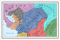
 Map of Kosovo Vilayet, Ottoman Empire (1900).jpg 800 × 552; 42 KB
-
 Serbia1945.png 541 × 762; 32 KB
-
 Zhegra.png 1,860 × 1,970; 120 KB
.png)
-pt.svg)
.svg)
.svg)

.png)

.svg)
.svg)
.png)
.jpg)

