Category:Maps of the history of Arkhangelsk Oblast
Jump to navigation
Jump to search
Federal subjects of the Russian Federation:
Republics: Adygea · Bashkortostan · Buryatia · Chechnya · Chuvashia · (Crimea) · Dagestan · Ingushetia · Kabardino-Balkaria · Kalmykia · Karachay–Cherkessia · Karelia · Mari El · Mordovia · North Ossetia — Alania · Tatarstan · UdmurtiaKrais: Krasnoyarsk · Primorsky ·
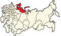
Oblasts: Arkhangelsk · Belgorod · Bryansk · Kursk · Leningrad · Moscow · Murmansk · Oryol · Pskov · Smolensk · Tver · Voronezh ·
Federal cities: Moscow · Saint Petersburg ·
Autonomous oblast:
Autonomous okrugs:
Subcategories
This category has only the following subcategory.
M
Media in category "Maps of the history of Arkhangelsk Oblast"
The following 11 files are in this category, out of 11 total.
-
 A generall chart of the northerne navigation RMG F8056.tiff 4,800 × 3,668; 50.37 MB
-
-
 Kitchen-21-Russian-Lapland-2801.jpg 2,560 × 1,920; 2.05 MB
-
 Kotlasskiy kraevedcheskiy musey (016).JPG 2,662 × 2,206; 859 KB
-
 Moscovia Delisle Guillaume 1706.jpg 5,413 × 3,999; 5.39 MB
-

-
 Pomorye, Map (XVII).jpg 4,560 × 4,122; 17.46 MB
-
 Russian North colonization.jpg 2,000 × 1,517; 774 KB
-
 The industries of Russia (1893) (14756188214).jpg 2,692 × 3,332; 948 KB
-
-
 UBBasel Map Russland 1651 Kartenslg Mappe 248-6.tif 11,886 × 9,208, 2 pages; 313.15 MB


.JPG)

,_RP-P-1896-A-19368-2996.jpg)
.jpg)

_(14756188214).jpg)
_(14751196305).jpg)