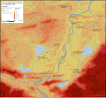
Deutsch: Karten des Gewässersystems der
Lech
English: Maps of the
Lech watercourse system
<nowiki>Категория:Бассейн Леха; Kategorie:Flusssystem Lech; Category:Lech basin; تصنيف:حوض نهر ليخ; Kategorie:Povodí Lechu; Kategori:Lech Havzası; categoría de Wikimedia; kategori Wikimedia; Wikimedia category; د ويکيمېډيا وېشنيزه; Vikimedya kategorisi; ویکیپیڈیا:زمرہ بندی; kategórie Wikimedie; Wikimèdia:Categorias; 维基媒体分类页; Wikimedia-Kategorie; Vikipediya:Turkumlashtirish; Викимедиина категорија; Wikimedia-Kategorie; विकिपीडिया:श्रेणी; page de catégorie d'un projet Wikimedia; Wikimedija:Kategorije; विकिपीडिया:वर्ग; категорија на Викимедији; Wikimedia-Kategorie; Wikimedia-kategori; kategori Wikimédia; تصنيف ويكيميديا; pajenn rummata eus Wikimedia; Wikimedia:ကဏ္ဍခွဲခြင်း; Wikimedia:分類; Wikimedia категориясы; categoría de Wikimedia; Kategorie op Wikimedia; Wikimedia-Kategorie; Tudalen categori Wikimedia; Viciméid catagóir; ردهٔ ویکیمدیا; 维基媒体分类页; Wikimedia-kategory; ვიკიპედია:კატეგორიზაცია; ウィキメディアのカテゴリ; categoria Wikimedia; تصنيف بتاع ويكيميديا; විකිමීඩියා ප්රභේද පිටුව; categoria Vicimediorum; विकिपीडिया:श्रेणी; Wikipedia:Categorization; Wikimedia-luokka; Wikimedia-categorie; gurühi Vikimedia; катэгорыя ў праекце Вікімэдыя; Викимедиа проектындагы төркем; catiguria di nu pruggettu Wikimedia; หน้าหมวดหมู่วิกิมีเดีย; Wikimedia:Kategorija; Wikimedia-Kategorie; Wikimedia:Klassys; Уикимедия категория; categorie pe paginile Wikimedia; 維基媒體分類頁; Wikimedia-kategori; kawan Wikimèdia; 維基媒體分類頁; 위키미디어:분류; Wikimedia-bólkur; kategorio en Vikimedio; kategori Wikimedia; categoría de Wikimedia; উইকিপিডিয়া:বিষয়শ্রেণীকরণ; kategori Wikimedia; 维基媒体分类页; װיקיפּעדיע:קאטעגאריזאציע; kategorija w projektach Wikimedije; thể loại Wikimedia; Wikimedia projekta kategorija; kategoria ti Wikimedia; categoria de um projeto da Wikimedia; 维基媒体分类页; категорияд Ангилал; Wikimedia-kategori; kategori Wikimedia; پەڕەی پۆلی ویکیمیدیا; Wikimedia category; Vikimédia ñemohenda; Wikimédia:Kategóriák; વિકિપીડિયા:શ્રેણી; Wikimediako kategoria; категория в проекте Викимедиа; Wikimedia-Kategorie; Викимедиа проектан категореш; Kategoriya ning Wikimedia; Wikimedia-categorie; Wikimedia-kategorie; Wîkîmediya:Kategorî; विकिमिडिया श्रेणी; σελίδα κατηγοριοποίησης εγχειρημάτων Wikimedia; Wikimedia-Kategorie; 維基媒體分類頁; kategori e Wikimedias; Վիքիմեդիայի նախագծի կատեգորիա; קטגוריה במיזמי ויקימדיה; Википедия:Төркемләү; Wikimedia:Kategorisasyon; categurìa 'e nu pruggette Wikimedia; వికీమీడియా వర్గపు పుట; Wikimedia:Klassifiseren; гурӯҳ дар лоиҳаи Викимедиа; Wikimedia-categorie; Vikipidiya:Shopni; विकिमिडिया श्रेणी; categoria di un progetto Wikimedia; kategoria Wikipedii; гурӯҳи Викимедиа; Wikimedia category page; Wikimedia kategooria; Wikimedia-kategorie; kategorya ng Wikimedia; катэгорыя ў праекце Вікімедыя; উইকিমিডিয়া থাক; ẹ̀ka Wikimedia; Викимедиа категорияһы; categoria de um projeto da Wikimedia; Wikimedia:Ronnaghys; kategorie na projektech Wikimedia; tumbung Wikimedia; Vikimedija:Straipsnių kategorizavimo taisyklės; Wikimedija:Kategorizacija; Wikimedia proyektındağı törkem; kategorija na Wikimediji; категорія проєкту Вікімедіа; kategori Wikimedia; jamii ya Wikimedia; വിക്കിപീഡിയ:വർഗ്ഗീകരണം; 維基媒體分類頁; kategori Wikimedia; விக்கிமீடியப் பகுப்பு; زمرو:وڪيپيڊيا زمرا بندي; categoria de Wikimedia; categoría de Wikimedia; Wikimedia-kategori; 维基媒体分类页; Wikimedia category</nowiki>


