Category:Maps of Uttarakhand
Jump to navigation
Jump to search
States of India: Andhra Pradesh · Arunachal Pradesh · Assam · Bihar · Chhattisgarh · Goa · Gujarat · Haryana · Himachal Pradesh · Jharkhand · Karnataka · Kerala · Madhya Pradesh · Maharashtra · Manipur · Meghalaya · Mizoram · Nagaland · Odisha · Punjab · Rajasthan · Sikkim · Tamil Nadu · Telangana · Tripura · Uttar Pradesh · Uttarakhand · West Bengal
Union territories: Andaman and Nicobar Islands · Chandigarh · Dadra and Nagar Haveli and Daman and Diu · Delhi · Jammu and Kashmir · Ladakh · Lakshadweep · Puducherry
Former states of India: Jammu and Kashmir ·
Former union territories: Dadra and Nagar Haveli district · Daman and Diu ·
Union territories: Andaman and Nicobar Islands · Chandigarh · Dadra and Nagar Haveli and Daman and Diu · Delhi · Jammu and Kashmir · Ladakh · Lakshadweep · Puducherry
Former states of India: Jammu and Kashmir ·
Former union territories: Dadra and Nagar Haveli district · Daman and Diu ·
Wikimedia category | |||||
| Upload media | |||||
| Instance of | |||||
|---|---|---|---|---|---|
| Category combines topics | |||||
| Uttarakhand | |||||
Indian state   someja satełitar in zuño .svg)  | |||||
| Instance of | |||||
| Named after | |||||
| Location | India | ||||
| Capital | |||||
| Legislative body |
| ||||
| Executive body |
| ||||
| Head of state |
| ||||
| Head of government |
| ||||
| Inception |
| ||||
| Highest point | |||||
| Population |
| ||||
| Area |
| ||||
| Different from | |||||
| official website | |||||
 | |||||
Subcategories
This category has the following 6 subcategories, out of 6 total.
Pages in category "Maps of Uttarakhand"
This category contains only the following page.
Media in category "Maps of Uttarakhand"
The following 23 files are in this category, out of 23 total.
-
 Artistic Map of a part of Himalayas.jpg 6,000 × 4,500; 3.52 MB
-
 Artistic Map of Uttarakhand with height shading.jpg 7,200 × 6,400; 17.09 MB
-
 Bhagirathi river map.JPG 1,304 × 2,000; 192 KB
-
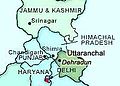 Dehradun indien.jpg 200 × 144; 8 KB
-
 Dhauliganga River basin.jpg 600 × 710; 210 KB
-
 India Uttarakhand Alaknanda River Valley.jpg 1,068 × 726; 324 KB
-
 India Uttarakhand relief map.svg 957 × 795; 1.59 MB
-
 Kumaon Garhwal.jpg 650 × 572; 92 KB
-
 Map Kumaon 1851.jpg 1,831 × 1,384; 1.61 MB
-
 Map of Uttarakhand.jpg 3,000 × 1,687; 2.96 MB
-
 Naag Tibba Trek Map cpt.jpg 725 × 425; 63 KB
-
 Nanda Devi Sanctuary sketch map.svg 4,270 × 3,318; 265 KB
-
 Nanda Devi Sanctuary.svg 4,270 × 3,318; 266 KB
-
 Nanda-region-map-annotated.jpg 621 × 597; 366 KB
-
 Nanda-sanctuary-annotated.jpg 535 × 688; 307 KB
-
 PINDARI GLACIERMAPENGLISH made by Sumita Roy.png 745 × 1,053; 123 KB
-
 Schematic Tourist Map of Uttarakhand.jpg 1,024 × 768; 93 KB
-
 Tehsils of Uttarakhand (Schematic).png 2,496 × 1,180; 352 KB
-
 Thalisain Map.jpg 692 × 706; 148 KB
-
 Uttarakhand Divisions Map.png 2,000 × 1,802; 420 KB
-
 Uttarakhand outline shape.svg 300 × 300; 73 KB
-
 Uttarakhand stub.svg 1,463 × 1,354; 16 KB
-
 Uttarakhand.png 1,231 × 896; 1.16 MB


.png)


