Category:Maps of Putnam County, Indiana (style A)
Jump to navigation
Jump to search
Media in category "Maps of Putnam County, Indiana (style A)"
The following 13 files are in this category, out of 13 total.
-
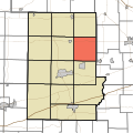
 Map highlighting Clinton Township, Putnam County, Indiana.svg 512 × 512; 38 KB
-
 Map highlighting Cloverdale Township, Putnam County, Indiana.svg 512 × 512; 38 KB
-
 Map highlighting Floyd Township, Putnam County, Indiana.svg 512 × 512; 38 KB
-
 Map highlighting Franklin Township, Putnam County, Indiana.svg 512 × 512; 38 KB
-
 Map highlighting Greencastle Township, Putnam County, Indiana.svg 512 × 512; 38 KB
-
 Map highlighting Jackson Township, Putnam County, Indiana.svg 512 × 512; 38 KB
-
 Map highlighting Jefferson Township, Putnam County, Indiana.svg 512 × 512; 38 KB
-
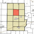
 Map highlighting Madison Township, Putnam County, Indiana.svg 512 × 512; 38 KB
-
 Map highlighting Marion Township, Putnam County, Indiana.svg 512 × 512; 38 KB
-
 Map highlighting Monroe Township, Putnam County, Indiana.svg 512 × 512; 38 KB
-
 Map highlighting Russell Township, Putnam County, Indiana.svg 512 × 512; 38 KB
-
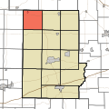
 Map highlighting Warren Township, Putnam County, Indiana.svg 512 × 512; 38 KB
-
 Map highlighting Washington Township, Putnam County, Indiana.svg 512 × 512; 38 KB


