Category:Maps of Paris in the 1810s
Jump to navigation
Jump to search
Subcategories
This category has the following 2 subcategories, out of 2 total.
Media in category "Maps of Paris in the 1810s"
The following 32 files are in this category, out of 32 total.
-
 1812 – Carte des Environs de Paris.jpg 9,512 × 6,632; 11.29 MB
-
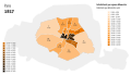 Population density of Paris, 1817 - Demographia.svg 512 × 293; 185 KB
-

-
 Carte détaillée des environs de Paris, 1816 - Stanford Libraries.jpg 7,375 × 6,003; 14.97 MB
-

-
 Charles Picquet, Plan Routier de la Ville de Paris Divise en XII Arrondissements, 1814 - David Rumsey.jpg 32,784 × 19,772; 253.85 MB
-

-
 Esnault, Nouveau Plan Routier De La Ville De Paris Et De Ses Faubourgs, 1811 - David Rumsey.jpg 26,736 × 16,582; 162.19 MB
-

-
 Georges Cuvie, Carte geognostique des environs de Paris - David Rumsey.jpg 14,990 × 12,807; 68.17 MB
-
 Jacques Esnauts, Nouveau plan des environs de Paris et Département de Seine et Oise.jpg 8,993 × 6,248; 49.6 MB
-
 Jacques Esnauts, Nouveau plan des environs de Paris et Département de Seine et Oise.tiff 10,386 × 6,271; 186.37 MB
-
 L1071.png 320 × 237; 157 KB
-
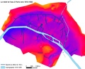 Le relief et les égouts vers 1810-1830 - ALPAGE.pdf 1,229 × 1,000; 434 KB
-
 Le relief et les égouts vers 1810-1830 - ALPAGE.svg 590 × 480; 307 KB
-
 Nouveau plan de Paris, divisé en 12 arrondissements, 1817 - National Library of Australia.jpg 23,232 × 17,971; 172.82 MB
-

-
 Nouveau plan routier de la ville et faubourgs de Paris, ca. 1810-1812 - Stanford Libraries.tiff 5,337 × 4,116; 20.98 MB
-

-
 Plan de la ville de Paris nouvellement dressé - Norman B. Leventhal Map Center.jpg 6,600 × 4,990; 7.73 MB
-
 Plan de la ville de Paris nouvellement dressé - Norman B. Leventhal Map Center.tif 6,600 × 4,990; 94.25 MB
-
-
 Plan de Paris divisé en 12 mairies, Subdivisée chacune en quatre Patries, 1811 - Paris Musées.jpg 18,682 × 13,185; 190.73 MB
-
 Plan général du siège de Paris en 1814 - 1815.jpg 1,754 × 1,502; 2.53 MB
-

-
 Plan routier de la ville et fauxbourgs de Paris - Norman B. Leventhal Map Center, original.jpg 9,924 × 6,677; 66.76 MB
-
 Plan routier de la ville et fauxbourgs de Paris - Norman B. Leventhal Map Center.tif 9,924 × 6,677; 189.6 MB
-

-
-
 Plan routier de la ville et fauxbourgs de Paris, 1813 - Stanford Libraries.jpg 13,098 × 8,872; 24.79 MB
-
 Plan routier de la ville et fauxbourgs de Paris, 1813 - Stanford Libraries.tif 13,098 × 8,872; 110.85 MB
-
 Vue de Paris du haut du Pavillon de Flore aux Tuileries, 1810 - David Rumsey.jpg 8,022 × 10,316; 21.21 MB


