Category:Maps of 12th-century Europe
Jump to navigation
Jump to search
| Preceded by: Maps of 11th-century Europe |
Maps of 12th-century Europe 1101 AD-1200 AD |
Succeeded by: Maps of 13th-century Europe |
Subcategories
This category has the following 8 subcategories, out of 8 total.
Media in category "Maps of 12th-century Europe"
The following 77 files are in this category, out of 77 total.
-
 Europe en 1100.pdf 1,752 × 1,239; 500 KB
-
 1130 CE, Europe.svg 512 × 438; 1.77 MB
-
 The Normans in Europe (1877) (14774557845).jpg 1,886 × 1,538; 474 KB
-
 Europe en 1150.pdf 1,752 × 1,239; 496 KB
-
 1173 CE, Europe.svg 512 × 438; 1.77 MB
-
 AtHistEur1180.jpg 1,890 × 2,070; 694 KB
-
 Great Britain and Ireland 1190.svg 120 × 170; 256 KB
-
 Historical atlas of modern Europe 1903 (135895367).jpg 9,149 × 6,906; 55.11 MB
-
 Karta orienten 1190.jpg 1,642 × 942; 583 KB
-
 The Crusades (Atlas of European history, 1909).PNG 850 × 1,242; 1.23 MB
-

-

-
 Armenia in 13th century.jpg 2,496 × 1,952; 3.69 MB
-
 Arnulf de Montgomery, Wikipedia article map.png 771 × 979; 197 KB
-
 Baltiskai gintu.png 2,000 × 2,185; 587 KB
-
 Benjamin of Tudela Zabustrisa Ravennika.jpg 987 × 938; 124 KB
-
 Blank map of Europe 1190.svg 550 × 375; 994 KB
-
 Bosnian Banate in 1204.svg 884 × 706; 929 KB
-
 Cities in Sweden 1200.png 448 × 600; 441 KB
-
 Comté d'Auvergne sous Guy II (1194).png 524 × 538; 60 KB
-

-
 Conquetes Philippe Auguste.png 800 × 600; 101 KB
-
 Conquistas de Felipe Augusto ca.svg 10,072 × 7,059; 324 KB
-
 Conquistas de Felipe Augusto es.svg 9,442 × 6,618; 304 KB
-
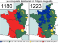 Conquiste territoriali Filippo Augusto.png 796 × 596; 75 KB
-
 County of Soissons (1180).png 427 × 398; 107 KB
-
 Distribution géographique premiers sceaux armoriés (1110-1160).svg 730 × 585; 265 KB
-
 Duché de Normandie.svg 1,877 × 1,576; 85 KB
-
 Dux Wasconum 1150-es.svg 2,000 × 1,360; 571 KB
-
 Dux Wasconum 1150.png 1,984 × 1,344; 362 KB
-
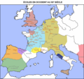 Ecoles XIIe s - 2.png 1,206 × 1,138; 132 KB
-
 Ecoles XIIe s.png 1,206 × 1,138; 137 KB
-
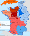
 English and French holdings 1180-1223.png 800 × 515; 93 KB
-
 Europa w XII wieku (Ultima Thule).jpg 756 × 596; 151 KB
-
 Europe 1096-1254 - Religions - Arnaud de Vachon.png 1,254 × 936; 903 KB
-
 Europe 1142.jpg 1,327 × 959; 536 KB
-
 Europe 1199ad political map.png 2,621 × 1,414; 592 KB
-
 Europe mediterranean 1190 (cropped).jpg 774 × 525; 129 KB
-
 Europe mediterranean 1190-ar.jpg 2,293 × 1,806; 1.34 MB
-
 Europe mediterranean 1190.jpg 2,293 × 1,810; 941 KB
-
 France 1154 Eng-ar.png 827 × 1,170; 565 KB
-
 France 1154 Eng.jpg 1,225 × 1,547; 711 KB
-
 France 1154-en (Angevin Empire).svg 1,405 × 1,675; 849 KB
-
 France 1154-es.svg 1,405 × 1,675; 1.14 MB
-
 France 1154-fr.png 1,226 × 1,551; 68 KB
-
 France 1154-nl.svg 1,405 × 1,675; 797 KB
-
 Geographical distribution of early armorial seals (1110-1160).svg 730 × 585; 248 KB
-

-
 Historická mapa - Čechy a Morava za zřízení župního ve XII století.jpg 2,758 × 2,291; 1.31 MB
-

-
 Map fr duchy of Gascony 1150-ru.svg 713 × 590; 93 KB
-
 Map fr duchy of Gascony 1150.svg 713 × 590; 447 KB
-
 Map France 1180-de.svg 988 × 1,124; 1.94 MB
-
 Map Kingdom Arelat AR.png 1,454 × 1,485; 856 KB
-
 Map Kingdom Arelat EN.png 1,310 × 1,338; 209 KB
-
 Map of Poitou in 1180.png 398 × 218; 88 KB
-
 Map Provence 1184.jpg 236 × 202; 90 KB
-
 Normans possessions 1155.png 1,394 × 1,012; 1.03 MB
-
 Normans possessions 12century es.png 1,400 × 1,018; 1.25 MB
-
 Normans possessions 12century-fr.png 1,394 × 1,012; 1.02 MB
-
 Polska 1102 - 1138-es.svg 11,510 × 11,360; 2.94 MB
-
 Polska 1102 - 1138.png 2,309 × 2,192; 1.11 MB
-
 Polska w latach 1102 - 1138.png 2,309 × 2,192; 1.4 MB
-
 Pontigny1180.png 2,664 × 2,456; 4.11 MB
-
 Premongol(2).png 752 × 590; 53 KB
-
 Public Schools Historical Atlas - England France 1152-1327.jpg 894 × 1,168; 321 KB
-
 Public Schools Historical Atlas - Europe 1135.jpg 2,234 × 1,734; 1,013 KB
-
 Putz31.jpg 3,607 × 2,835; 2.16 MB
-
 RebeliónDeIbnMardanis1160,svg.svg 2,268 × 1,396; 825 KB
-
 Scots lang-en.svg 720 × 980; 70 KB
-
 Serbie de Nemanja.svg 744 × 1,052; 348 KB
-
 Silesia1185-1201.png 560 × 561; 135 KB
-
 South Italy 1112.png 716 × 772; 87 KB
-
 Southern Italy 1112-cs.svg 712 × 807; 669 KB
-
 Wrymouth expedition pomerania lutici.png 634 × 534; 60 KB
-
 The Collegiate Atlas 1876 (73060103).jpg 6,736 × 4,886; 5.35 MB
-
 Сицилийское королевство 1154.png 716 × 772; 53 KB

_(14774557845).jpg)


.jpg)

.PNG)

)%27_(11152453156).jpg)


.png)


.png)
.svg)


.jpg)


.jpg)


.svg)


.svg)


%27_(11174838534).jpg)


.png)


.jpg)
