Category:Locator maps of countries of the African Union
Jump to navigation
Jump to search
Countries of Africa: Algeria · Angola · Benin · Botswana · Burkina Faso · Burundi · Cameroon · Cape Verde · Central African Republic · Chad · Comoros · Democratic Republic of the Congo · Republic of the Congo · Djibouti · Egypt‡ · Equatorial Guinea · Eritrea · Eswatini · Ethiopia · Gabon · The Gambia · Ghana · Guinea · Guinea-Bissau · Ivory Coast · Kenya · Lesotho · Liberia · Libya · Madagascar · Malawi · Mali · Mauritania · Mauritius · Morocco · Mozambique · Namibia · Niger · Nigeria · Rwanda · São Tomé and Príncipe · Senegal · Seychelles · Sierra Leone · Somalia · South Africa · South Sudan · Sudan · Tanzania · Togo · Tunisia · Uganda · Zambia · Zimbabwe
Limited recognition: Ambazonia · Sahrawi Arab Democratic Republic · Somaliland – Other areas: Canary Islands · Ceuta · Madeira · Mayotte · Melilla · Réunion · Saint Helena, Ascension and Tristan da Cunha · Western Sahara
‡: partly located in Africa
Limited recognition: Ambazonia · Sahrawi Arab Democratic Republic · Somaliland – Other areas: Canary Islands · Ceuta · Madeira · Mayotte · Melilla · Réunion · Saint Helena, Ascension and Tristan da Cunha · Western Sahara
‡: partly located in Africa
| NO WIKIDATA ID FOUND! Search for Locator maps of countries of the African Union on Wikidata | |
| Upload media |

Subcategories
This category has only the following subcategory.
Media in category "Locator maps of countries of the African Union"
The following 11 files are in this category, out of 11 total.
-
 Algeria in au.png 2,000 × 2,000; 536 KB
-
 Angola in au.png 2,000 × 2,000; 537 KB
-
 Benin in au.png 2,000 × 2,000; 537 KB
-
 Botswana in au.png 2,000 × 2,000; 537 KB
-
 Burkina faso in au.png 2,000 × 2,000; 537 KB
-
 Burundi in au.png 2,000 × 2,000; 538 KB
-
 Cameroon in au.png 2,000 × 2,000; 537 KB
-
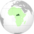 CAR in au.png 2,000 × 2,000; 537 KB
-
 Chad in au.png 2,000 × 2,000; 537 KB
-
 Republic of the Congo in the African Union.png 2,000 × 2,000; 537 KB
-
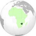 Zimbabwe in au.png 2,000 × 2,000; 536 KB


