Category:Geological maps of Tanzania
Jump to navigation
Jump to search
Countries of Africa: Algeria · Botswana · Cameroon · Cape Verde · Chad · Democratic Republic of the Congo · Egypt‡ · Eritrea · Ethiopia · Guinea · Madagascar · Mali · Mauritania · Morocco · Namibia · Niger · Nigeria · Rwanda · Senegal · South Africa · South Sudan · Sudan · Tanzania · Tunisia
Other areas: Canary Islands · Mayotte · Réunion
‡: partly located in Africa
Other areas: Canary Islands · Mayotte · Réunion
‡: partly located in Africa
Subcategories
This category has only the following subcategory.
M
Media in category "Geological maps of Tanzania"
The following 13 files are in this category, out of 13 total.
-
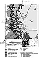
 Eastern Arc Mountains sheme (2).jpg 400 × 410; 38 KB
-
 Eastern Arc Mountains sheme.jpg 333 × 339; 29 KB
-
 Geologic map Tendaguru Formation members, Tanzania.jpg 491 × 718; 148 KB
-
 Lifua Member of the Manda beds.png 958 × 1,138; 106 KB
-
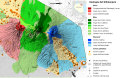 Mount Kilimanjaro Geology map-es.svg 2,670 × 1,721; 1.03 MB
-
 Mount Kilimanjaro Geology map-fr.jpg 2,670 × 1,721; 1.27 MB
-
 Mount Kilimanjaro Geology map-fr.svg 2,670 × 1,721; 1.03 MB
-
 Mount Kilimanjaro Geology map-nl (crop).png 1,928 × 1,721; 3.11 MB
-
 Mount Kilimanjaro Geology map-nl (crop).svg 1,934 × 1,721; 1,021 KB
-
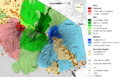 Mount Kilimanjaro Geology map-nl.png 2,670 × 1,721; 3.92 MB
-
 Mount Kilimanjaro Geology map-nl.svg 2,670 × 1,721; 1.03 MB
-
 Tanzania Hydrogeology3.png 769 × 939; 41 KB
-
 Tanzania map Karoo and coal.png 4,796 × 4,971; 1.2 MB
.jpg)


.png)
.svg)


