
Category:Geological maps of South Africa
Countries of Africa: Algeria · Botswana · Cameroon · Cape Verde · Chad · Democratic Republic of the Congo · Djibouti · Egypt‡ · Eritrea · Ethiopia · Guinea · Madagascar · Mali · Mauritania · Mauritius · Morocco · Namibia · Niger · Nigeria · Rwanda · Senegal · Somalia · South Africa · South Sudan · Sudan · Tanzania · Tunisia
Other areas: Canary Islands · Mayotte · Réunion
‡: partly located in Africa
Other areas: Canary Islands · Mayotte · Réunion
‡: partly located in Africa
Subcategories
This category has the following 2 subcategories, out of 2 total.
*
M
- Maps of the Witwatersrand (18 F)
Media in category "Geological maps of South Africa"
The following 36 files are in this category, out of 36 total.
-
 Geological Sketch Map of South Africa - by E. J. Dunn.jpg 11,361 × 9,426; 14.66 MB
-

-
 Bulletin de la Société géologique de France (1901) (20436907585).jpg 3,684 × 2,804; 2.21 MB
-
 Bushveld Igneous Complex.png 2,792 × 1,748; 373 KB
-
 Cape-Vaal Craton.png 3,472 × 2,344; 159 KB
-
 Carte du Witwatersrand, Transvaal.jpg 2,400 × 1,750; 1.42 MB
-

-
 Cratons d afrique australe.svg 360 × 247; 49 KB
-
 Geological Legend for map of the Geology of the Cape Peninsula and False Bay.png 1,861 × 3,000; 580 KB
-
 Geological map of the Cape Peninsula and False Bay.png 2,793 × 3,505; 2.18 MB
-
 Geological Map.jpg 1,754 × 2,484; 500 KB
-
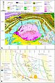 Geological setting of Cradle of Humankind and Rising Star cave system.jpg 3,148 × 4,742; 1.51 MB
-
 Geology of Cape Peninsula 1.jpg 4,000 × 5,064; 1.14 MB
-
 Geology of Karoo Supergroup.png 5,960 × 3,625; 292 KB
-
 Gold fields.jpg 3,980 × 2,688; 780 KB
-
 Great Escarpment map 1.png 8,173 × 5,545; 746 KB
-
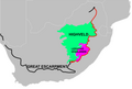
 Lowveld map 1.png 8,080 × 5,760; 718 KB
-
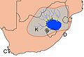
 Map of Kaapvaal craton.svg 335 × 265; 35 KB
-
 Quaternary Coastlines A5.gif 1,275 × 770; 28 KB
-
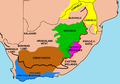 Regions of South Africa 1.png 2,000 × 1,394; 771 KB
-
 Simplified geologic map of the Barberton greenstone belt.pdf 1,666 × 1,250; 224 KB
-
 South African Geology - Schwarz - 1912 Fig 33.png 827 × 617; 453 KB
-
 South African Geology - Schwarz - 1912 Fig 37.png 707 × 618; 193 KB
-
 South African Greenstone Belt.png 369 × 396; 429 KB
-
 Southern African Central Plateau.jpg 9,960 × 6,756; 2.92 MB
-
 The Escarpment and the Drakensberg.jpg 9,960 × 6,756; 3.08 MB
-
 The Quarterly journal of the Geological Society of London (1898) (14755838696).jpg 3,438 × 1,508; 298 KB
-
 The Quarterly journal of the Geological Society of London (1898) (14778506372).jpg 3,038 × 2,536; 1.53 MB
-
 Transactions (1871) (14596777769).jpg 3,760 × 2,084; 668 KB
-
 Uitenhage Group Algoa Gamtoos map.png 2,784 × 1,504; 2.58 MB
-
 Vereenvoudige geologiese kaart van Suid-Afrika.jpg 736 × 525; 57 KB
-
 Vredefort crater & Witwatersrand.png 4,226 × 3,956; 383 KB
-
 Vredefort crater & Witwatersrand2.png 4,226 × 3,956; 276 KB
-
 Witwatersrand gold.png 736 × 579; 72 KB
-
 Witwatersrand outcrops 2.jpg 10,000 × 9,902; 2.62 MB
-
 Witwatersrand.jpg 308 × 279; 20 KB

.jpg)
_(20436907585).jpg)


_(14755838696).jpg)
_(14778506372).jpg)


_(14596777769).jpg)