Category:2017 maps of India
Jump to navigation
Jump to search
Countries of Asia: People's Republic of China · India · Indonesia‡ · Iraq · Japan · Philippines · Russia‡ · Syria · Turkey‡
‡: partly located in Asia
‡: partly located in Asia
English: 2017 maps made in India or from India or showing history of India
Media in category "2017 maps of India"
The following 19 files are in this category, out of 19 total.
-
 12th century Belur Chenna Kesava temples complex plan, Karnataka India.jpg 1,766 × 2,328; 770 KB
-
 12th century Belur Chenna Kesava temples layout ground plan, Karnataka India.jpg 1,514 × 2,034; 403 KB
-
 201705230 TC MORA.pdf 1,625 × 1,125; 831 KB
-
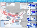
 20170817 Nepal India Bangladesh Floods.pdf 1,754 × 1,239; 962 KB
-
 ECDM 20170703 Asia Events.pdf 1,625 × 1,125; 703 KB
-
 ECDM 20170718 India SW.pdf 1,625 × 1,125; 703 KB
-
 ECDM 20170801 India SW.pdf 1,625 × 1,125; 784 KB
-
 ECDM 20170821 Asia Events.pdf 1,625 × 1,125; 810 KB
-
 ECDM 20170829 Nepal India Bangladesh Floods.pdf 1,754 × 1,239; 1.19 MB
-
 ECDM 20171204 India-SriLanka Maldives TC.pdf 1,625 × 1,125; 708 KB
-
 ECHO Daily Map of 1 September 2017 v2.pdf 1,500 × 1,125; 204 KB
-
 India-map-ml-political-parties-2017.png 5,011 × 5,623; 2.07 MB
-
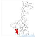 Jhargram district.svg 576 × 601; 133 KB
-
 Per Capita Income of India 2017.png 1,908 × 2,264; 427 KB
-
 Plan de Bombay.jpg 4,160 × 3,120; 1.56 MB
-
 Prohibition in Indien 2017.svg 698 × 768; 683 KB
-
 Prohibition in Indien 2019.svg 698 × 768; 687 KB
-
 Präsidentschaftswahl in Indien 2017.svg 719 × 796; 718 KB
-


,_Department_of_Science_%26_Technology,_in_Kolkata_(1).jpg)