Category:2017 maps of Indonesia
Jump to navigation
Jump to search
Media in category "2017 maps of Indonesia"
The following 47 files are in this category, out of 47 total.
-
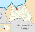
 (Peta Lokasi) Desa Aek Bolon Jae, Balige, Tobasa.svg 512 × 469; 384 KB
-
 (Peta Lokasi) Desa Aek Bolon Julu, Balige, Tobasa.svg 512 × 469; 384 KB
-
 (Peta Lokasi) Desa Balige II, Balige, Tobasa.svg 512 × 469; 384 KB
-
 (Peta Lokasi) Desa Baruara, Balige, Tobasa.svg 512 × 469; 384 KB
-
 (Peta Lokasi) Desa Bonan Dolok I, Balige, Tobasa.svg 512 × 469; 384 KB
-
 (Peta Lokasi) Desa Bonan Dolok II, Balige, Tobasa.svg 512 × 469; 384 KB
-
 (Peta Lokasi) Desa Bonan Dolok III, Balige, Tobasa.svg 512 × 469; 384 KB
-
 (Peta Lokasi) Desa Hinalang Bagasan, Balige, Tobasa.svg 512 × 469; 384 KB
-
 (Peta Lokasi) Desa Huta Bulu Mejan, Balige, Tobasa.svg 512 × 469; 384 KB
-
 (Peta Lokasi) Desa Huta Dame, Balige, Tobasa.svg 512 × 469; 384 KB
-
 (Peta Lokasi) Desa Huta Namora, Balige, Tobasa.svg 512 × 469; 384 KB
-
 (Peta Lokasi) Desa Hutagaol Peatalun, Balige, Tobasa.svg 512 × 469; 384 KB
-
 (Peta Lokasi) Desa Longat, Balige, Tobasa.svg 512 × 469; 384 KB
-
 (Peta Lokasi) Desa Lumban Bulbul, Balige, Tobasa.svg 512 × 469; 384 KB
-
 (Peta Lokasi) Desa Lumban Gaol, Balige, Tobasa.svg 512 × 469; 384 KB
-
 (Peta Lokasi) Desa Lumban Gorat, Balige, Tobasa.svg 512 × 469; 384 KB
-
 (Peta Lokasi) Desa Lumban Pea Timur, Balige, Tobasa.svg 512 × 469; 384 KB
-
 (Peta Lokasi) Desa Lumban Pea, Balige, Tobasa.svg 512 × 469; 384 KB
-
 (Peta Lokasi) Desa Lumban Silintong, Balige, Tobasa.svg 512 × 469; 384 KB
-
 (Peta Lokasi) Desa Matio, Balige, Tobasa.svg 512 × 469; 384 KB
-
 (Peta Lokasi) Desa Paindoan, Balige, Tobasa.svg 512 × 469; 384 KB
-
 (Peta Lokasi) Desa Parsuratan, Balige, Tobasa.svg 512 × 469; 384 KB
-
 (Peta Lokasi) Desa Saribu Raja Janji Maria, Balige, Tobasa.svg 512 × 469; 384 KB
-
 (Peta Lokasi) Desa Sianipar Sihailhail, Balige, Tobasa.svg 512 × 469; 384 KB
-
 (Peta Lokasi) Desa Sibolahotang Sas, Balige, Tobasa.svg 512 × 469; 384 KB
-
 (Peta Lokasi) Desa Siboruon, Balige, Tobasa.svg 512 × 469; 384 KB
-
 (Peta Lokasi) Desa Sibuntuon, Balige, Tobasa.svg 512 × 469; 384 KB
-
 (Peta Lokasi) Desa Silalahi Pagar Batu, Balige, Tobasa.svg 512 × 469; 384 KB
-
 (Peta Lokasi) Desa Tambunan Sunge, Balige, Tobasa.svg 512 × 469; 384 KB
-
 (Peta Lokasi) Kelurahan Balige I, Balige, Tobasa.svg 512 × 469; 384 KB
-
 (Peta Lokasi) Kelurahan Balige III, Balige, Tobasa.svg 512 × 469; 384 KB
-
 (Peta Lokasi) Kelurahan Lumban Dolok Haumabange, Balige, Tobasa.svg 512 × 469; 384 KB
-
 (Peta Lokasi) Kelurahan Napitupulu Bagasan, Balige, Tobasa.svg 512 × 469; 384 KB
-
 (Peta Lokasi) Kelurahan Pardede Onan, Balige, Tobasa.svg 512 × 469; 384 KB
-
 (Peta Lokasi) Kelurahan Sangkar Nihuta, Balige, Tobasa.svg 512 × 469; 384 KB
-
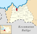
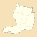
 (Peta Wilayah) Kecamatan Balige, Toba Samosir.svg 512 × 469; 384 KB
-
 Administrative division of Mataram.png 719 × 480; 172 KB
-
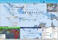
 ECDM 20170228 Inonesia SW Oveview-FINAL.pdf 1,625 × 1,125; 866 KB
-
 ECDM 20170703 Asia Events.pdf 1,625 × 1,125; 703 KB
-
 ECDM 20171129 Asia Events.pdf 1,625 × 1,125; 739 KB
-
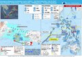 ECDM 20171218 Asia Events.pdf 1,625 × 1,125; 826 KB
-
 Indonesia Depok City location map.svg 1,250 × 1,250; 882 KB
-
 Indonesia provinces HDI 2017.svg 2,000 × 767; 433 KB
-
 Indonesia Sukabumi City location map.svg 1,250 × 1,250; 599 KB
-
 IPM Provinsi di Indonesia 2017.png 1,322 × 620; 145 KB
-
 Map of West Java highlighting Depok City.svg 512 × 397; 184 KB
-
 Map of West Java highlighting Sukabumi City.svg 512 × 397; 184 KB
_Desa_Aek_Bolon_Jae,_Balige,_Tobasa.svg)
_Desa_Aek_Bolon_Julu,_Balige,_Tobasa.svg)
_Desa_Balige_II,_Balige,_Tobasa.svg)
_Desa_Baruara,_Balige,_Tobasa.svg)
_Desa_Bonan_Dolok_I,_Balige,_Tobasa.svg)
_Desa_Bonan_Dolok_II,_Balige,_Tobasa.svg)
_Desa_Bonan_Dolok_III,_Balige,_Tobasa.svg)
_Desa_Hinalang_Bagasan,_Balige,_Tobasa.svg)
_Desa_Huta_Bulu_Mejan,_Balige,_Tobasa.svg)
_Desa_Huta_Dame,_Balige,_Tobasa.svg)
_Desa_Huta_Namora,_Balige,_Tobasa.svg)
_Desa_Hutagaol_Peatalun,_Balige,_Tobasa.svg)
_Desa_Longat,_Balige,_Tobasa.svg)
_Desa_Lumban_Bulbul,_Balige,_Tobasa.svg)
_Desa_Lumban_Gaol,_Balige,_Tobasa.svg)
_Desa_Lumban_Gorat,_Balige,_Tobasa.svg)
_Desa_Lumban_Pea_Timur,_Balige,_Tobasa.svg)
_Desa_Lumban_Pea,_Balige,_Tobasa.svg)
_Desa_Lumban_Silintong,_Balige,_Tobasa.svg)
_Desa_Matio,_Balige,_Tobasa.svg)
_Desa_Paindoan,_Balige,_Tobasa.svg)
_Desa_Parsuratan,_Balige,_Tobasa.svg)
_Desa_Saribu_Raja_Janji_Maria,_Balige,_Tobasa.svg)
_Desa_Sianipar_Sihailhail,_Balige,_Tobasa.svg)
_Desa_Sibolahotang_Sas,_Balige,_Tobasa.svg)
_Desa_Siboruon,_Balige,_Tobasa.svg)
_Desa_Sibuntuon,_Balige,_Tobasa.svg)
_Desa_Silalahi_Pagar_Batu,_Balige,_Tobasa.svg)
_Desa_Tambunan_Sunge,_Balige,_Tobasa.svg)
_Kelurahan_Balige_I,_Balige,_Tobasa.svg)
_Kelurahan_Balige_III,_Balige,_Tobasa.svg)
_Kelurahan_Lumban_Dolok_Haumabange,_Balige,_Tobasa.svg)
_Kelurahan_Napitupulu_Bagasan,_Balige,_Tobasa.svg)
_Kelurahan_Pardede_Onan,_Balige,_Tobasa.svg)
_Kelurahan_Sangkar_Nihuta,_Balige,_Tobasa.svg)
_Kecamatan_Balige,_Toba_Samosir.svg)


