Category:2017 maps of Canada
Jump to navigation
Jump to search
Countries of North America: Canada · Jamaica · Mexico · United States of America‡
‡: partly located in North America
‡: partly located in North America
| ← 2010 2011 2012 2013 2014 2015 2016 2017 2018 2019 → |
English: Maps of Canada from 2017 or related to Canada in 2017
Français : Les cartes du Canada de 2017 ou se rapportant au Canada en 2017
Media in category "2017 maps of Canada"
The following 5 files are in this category, out of 5 total.
-
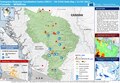
 20170316 USA SW.pdf 1,625 × 1,125; 754 KB
-
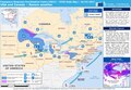
 20170711 Canada ForestFire.pdf 1,625 × 1,125; 924 KB
-
 Life Expectancy by Province.png 4,115 × 3,475; 1.09 MB
-
 Nunavut general election, 2017 results by riding.svg 798 × 721; 619 KB
-
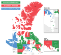 Nunavut Territorial Election 2017 - Incumbency Results by Riding.svg 798 × 721; 548 KB


