Category:2012 maps of Canada
Jump to navigation
Jump to search
Countries of North America: The Bahamas · Canada · Cuba · Honduras · Mexico · Saint Vincent and the Grenadines · United States of America‡
‡: partly located in North America
‡: partly located in North America
| ← 2010 2011 2012 2013 2014 2015 2016 2017 2018 2019 → |
English: Maps of Canada from 2012 or related to Canada in 2012
Français : Les cartes du Canada de 2012 ou se rapportant au Canada en 2012
Media in category "2012 maps of Canada"
The following 8 files are in this category, out of 8 total.
-
 Alta2012.png 3,229 × 3,871; 824 KB
-
 C-train routes.png 2,000 × 1,764; 459 KB
-
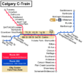
 Calgary C-Train map.svg 1,584 × 1,397; 67 KB
-
 Canada Alberta relief location map.jpg 2,184 × 2,692; 2.93 MB
-
 Canada Yukon location map-albers proj.svg 512 × 581; 444 KB
-
 Canada Yukon location map-albers proj2.svg 512 × 581; 444 KB
-
 CFL stadiums map.jpg 923 × 574; 27 KB
-
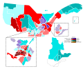 Quebec election 2012.svg 2,132 × 1,763; 452 KB


