Category:1953 maps of Europe
Jump to navigation
Jump to search
Temperate regions: North America · South America · Africa · Europe · Asia · – Polar regions: – Other regions:
English: 1953 maps of Europe
Español: Mapas de Europa en 1953
Suomi: Euroopan kartat vuodelta 1953
Română: Hărți ale Europei din 1953
Subcategories
This category has the following 7 subcategories, out of 7 total.
F
- 1953 maps of France (2 F)
L
- 1953 maps of Lithuania (1 F)
N
- 1953 maps of Norway (36 F)
P
- 1953 maps of Poland (1 F)
S
- 1953 maps of Sweden (6 F)
- 1953 maps of Switzerland (2 F)
T
- 1953 maps of Turkey (3 F)
Media in category "1953 maps of Europe"
The following 17 files are in this category, out of 17 total.
-
 Admiralty Chart No 1432 Ile Vierge to Point Scoune, Published 1953.jpg 11,243 × 8,284; 18.2 MB
-
 Admiralty Chart No 2985 La Loire St. Nazaire to Nantes, Published 1953.jpg 16,251 × 11,100; 62.49 MB
-
 Atlantic Ocean 1953.jpg 1,008 × 1,391; 527 KB
-
 Balkan Pact (1953) + NATO member states.png 1,173 × 984; 53 KB
-
 Croatia-Croats-1953op.png 1,000 × 990; 333 KB
-
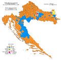
 Croatia-Ethnic-1953.png 1,000 × 990; 510 KB
-
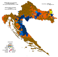
 Croatia-Ethnic-1953op.png 1,000 × 990; 364 KB
-
 Croatia-Ethnic-1953op2.png 1,000 × 990; 335 KB
-
 Croatia-Serbs-1953op.png 1,000 × 990; 353 KB
-
 Eurasia, 1953.jpg 1,621 × 1,276; 951 KB
-
 Europe 1914-1938-1950.jpg 1,140 × 1,460; 524 KB
-
 Muzeum Stavedlo 02.jpg 3,202 × 2,402; 1.87 MB
-
 Percentage of catholics in Bosnian kotars in 1953.gif 1,213 × 1,100; 69 KB
-
 Percentage of Orthodox in Bosnian kotars in 1953.GIF 1,213 × 1,100; 162 KB
-
 Provincial heritage.jpg 2,142 × 1,439; 978 KB
-
 Religious majority in Bosnian kotars in 1953.gif 1,213 × 1,100; 70 KB
-
 Tour de France 1953.png 600 × 600; 274 KB


_%2B_NATO_member_states.png)


