Category:1895 maps of Vermont
Jump to navigation
Jump to search
States of the United States: California · Connecticut · Florida · Georgia · Illinois · Iowa · Kentucky · Louisiana · Maine · Maryland · Massachusetts · Michigan · Minnesota · Mississippi · Missouri · Nevada · New Jersey · New York · Ohio · Oklahoma · Oregon · Pennsylvania · Rhode Island · South Carolina · Tennessee · Texas · Utah · Vermont · Virginia · Washington · West Virginia · Wisconsin · Wyoming – Washington, D.C.
| ← 1890 1891 1892 1894 1895 1897 1898 1899 → |
Media in category "1895 maps of Vermont"
The following 6 files are in this category, out of 6 total.
-

-
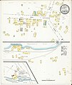
 Sanborn Fire Insurance Map from Barton Landing, Orleans County, Vermont. LOC sanborn08904 002.tif 6,450 × 7,650; 141.17 MB
-
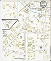
 Sanborn Fire Insurance Map from Lyndon, Caledonia County, Vermont. LOC sanborn08926 003.jpg 6,450 × 7,650; 3.08 MB
-
 Sanborn Fire Insurance Map from Lyndon, Caledonia County, Vermont. LOC sanborn08926 003.tif 6,450 × 7,650; 141.17 MB
-
-
 Sanborn Fire Insurance Map from North Troy, Orleans County, Vermont. LOC sanborn08934 002.tif 6,450 × 7,650; 141.17 MB


